Flood warning issued for Squamish River, tributaries: B.C. forecast centre
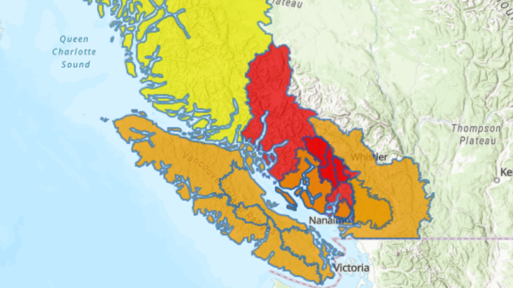
 This screenshot of a map from the River Forecast Centre shows flood warnings (red,) flood watches (orange) and high streamflow advisories (yellow) in effect on Jan. 29, 2024.
British Columbia's River Forecast Centre issued an upgrade flood warning for the Squamish River and tributaries including the Cheakamus River on Monday, as another torrent of heavy rain was expected across the province's South Coast.
A bulletin at 5:15 p.m. said water levels in the Squamish River were rising, with flows reaching somewhere between a two- and five-year return period at a gauge near Brackendale, a neighbourhood north of downtown Squamish, B.C.
With additional rainfall expected in the river's headwaters, the water levels may continue rising into Tuesday, it said.
Tributaries including the Cheakamus River were also “expected to exceed bank-full flow,” the bulletin said.
The forecast centre has maintained flood watches for the rest of the province's South Coast, spanning all of Vancouver Island, the Sunshine Coast, the North Shore mountains and parts of the Fraser Valley, including the Sumas River.
Lower-level streamflow advisories are in effect for the Central and North coasts.
River levels were expected to peak in most areas on Monday and Tuesday.
The River Forecast Centre said the “potent” storms had delivered between 80 and 300 millimetres of rain through most of the region since Friday.
Alyssa Charbonneau, a meteorologist with Environment Canada, said Monday that warm air accompanying the series of atmospheric rivers saturating the region is raising the risk of flooding by melting snow in the mountains, causing runoff.
Charbonneau said there may be some breaks in the heaviest rains, but the concerns over flooding come from the “cumulative event” and its extended duration.
The weather office maintained a rainfall warning on Monday covering Squamish, Whistler and other communities near Howe Sound, saying another 60 to100 mm was forecast before the rain eases to light showers Tuesday morning.
Charbonneau said the rain is expected to persist until sometime in the middle of the week, perhaps Wednesday night, before easing up.
“We do see things cooling down toward seasonal, and it does look like we're going to have a stretch of dry weather through the weekend,” she said.
Still, she cautioned, the longer-term forecast for B.C.'s South Coast should be taken “with a grain of salt” at this time of year because it can change quickly.
A bulletin from Avalanche Canada, meanwhile, said rain had saturated and weakened the upper snowpack in several mountain ranges.
The danger is ranked at “high” in the south Chilcotin and Pacific mountain ranges, including Whistler and Pemberton, as well as northwestern B.C.
The forecaster downgraded the rating to “considerable” in mountains in southeastern B.C. and along the boundary with Alberta later on Monday.
The danger is also classified as “considerable” in mountains throughout the Fraser Valley and parts of the central Interior, while it's ranked at “moderate” along the North Shore mountains, the Sunshine Coast and parts of Vancouver Island.
The forecaster's map indicates the risk is expected to remain high Tuesday in the south Chilcotin and Pacific ranges, including the Garibaldi area around Whistler.
This report by The Canadian Press was first published Jan. 29, 2024.
CTVNews.ca Top Stories

Forecasters issue 'bomb cyclone' warning for B.C., with 120 km/h winds predicted
An Environment Canada meteorologist says a so-called "bomb cyclone" is expected to bring powerful winds to Vancouver Island and the British Columbia coast this week.
Canada's rising youth unemployment could cost the country billions, report says
The unemployment rate for Canadians between 18 and 24 was 12.8 per cent in October, according to Statistics Canada, more than double the rate of those older than 25.
Tories call on Boissonnault to resign amid apology over Indigenous ancestry claims
Members of Parliament returned to Ottawa on Monday after a weeklong break with no sign of a resolution to the House stalemate, tempers ramped back up, and renewed calls for a Liberal cabinet minister to resign — or be fired.
B.C. RCMP detachment refutes social media claims of human trafficking, kidnapping
Mounties in B.C.'s Sea to Sky region say there is "no credible evidence" to support claims circulating on social media that a human trafficking ring is operating in Squamish or that there have been kidnappings in the community.
Men from Ontario, B.C. charged in 'mistaken identity' shooting, RCMP say
Two men from Ontario and British Columbia have been charged in connection with a 2022 shooting that left an innocent victim seriously wounded.
NHL referee Mitch Dunning communicative, can move extremities following violent collision
NHL referee Mitch Dunning is fully communicative and can move all his extremities following a violent collision with Colorado defenseman Josh Manson in Monday night's game at Philadelphia.
Dave Coulier debuts shaved head with a little help from his friend John Stamos
As Dave Coulier continues to go through cancer treatment, he is getting some support from his friend John Stamos.
Some Canada-U.S. border crossing times will change in 2025. Here's what you need to know
The Canada Border Services Agency (CBSA) says it will adjust the opening hours of crossing points across the country early next year.
Thief steals disabled 15-year-old dog's wheelchair
Caring for a senior pet is no walk in the park, especially when the pet can't walk at all. A Colorado woman was shocked to find her dog's wheelchair missing from the porch Tuesday morning


