Feb. 13 update: Environment Canada is now forecasting a chance of further flurries Thursday and Friday. Here's the updated outlook.
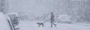
A snowfall warning first announced Sunday is still in effect, and while the wintry weather is only Vancouver's second dose of snow this year, many are already sick of it.
So when will the sudden blast of cold be over? Thursday or Friday, Environment Canada suggests.
The latest forecast calls for rain and snow on Thursday, but the high is expected to reach 4 C. There's a 60 per cent chance of precipitation, and if it falls as rain, it may wash away the snow that first fell over the weekend. Check out the latest forecast on our weather page.
Friday and Saturday are expected to be warmer still, with forecasted highs of 5 and 6 C. Sunday should be sunny and 4 C.
And the melt may begin as early as Wednesday, when the mercury is forecast to climb above 0. Environment Canada predicts a high of 2, and says the skies will clear in the morning.
The temperatures are still below the average high for this time of year, which is about 8 C, and the weather agency expects it will still be below the freezing mark most nights.
The forecast for areas outside of Metro Vancouver, including Abbotsford and Chilliwack, suggest there could still be snowfall on Saturday, but there will be warmer temperatures in the days to come.