A record-breaking warm April had Vancouver-area residents expecting a warm summer, but instead the city is seeing unusually cold temperatures.
Tuesday was the second coldest Aug. 2 on record in Vancouver, with a high that felt 10 degrees cooler than the day before.
On Monday, Environment Canada reported that the mercury reached 22 C, but with the humidity it felt closer to 26. But on the soggy second day of August, when those who'd been off for the holiday returned to work, the high was an unseasonably low 16 C. The norm for this time of year is 22.
Though the temperature is only six degrees shy of the seasonal norm, it seemed colder after a weekend of sunshine and temperatures in the mid-20s.
Tuesday was the coldest Aug. 2 since 1937, when the temperature fell to a chilly 8.3 C, according to Environment Canada records. The warmest was in 2007, when Vancouver was a balmy 26.7.
This year's temperature ups-and-downs began in April, when decades-old records were shattered across the province. In the middle of the month, temperatures rose to 25 C, breaking a record set in 1962.
In early May, temperature records tumbled again when the all-time high set in 1944 was broken with a high of 25.
It appeared that the Lower Mainland was on track for a record summer, but a cool June ushered in a winter-like pattern. The wet and miserable weather continued into July, and lasted for the first half of the month.
The forecast turned around in the last two weeks, when heat exhaustion hit several people as the mercury soared to 30 C.
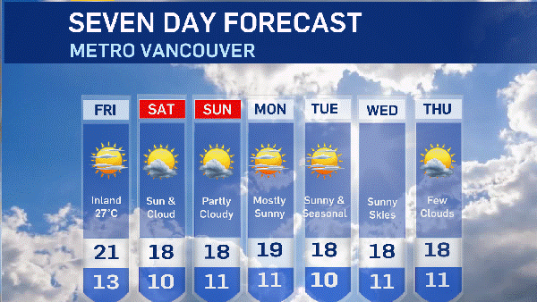
But this week, Environment Canada forecasts highs of between 20 and 22 all week, with cloudy skies every day except Thursday. The rain is expected to continue on Wednesday, but the rest of the week should be dry, the weather agency predicts.