Snowfall warnings issued for B.C. Interior
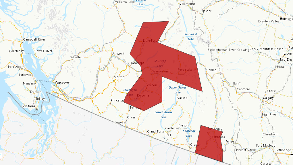
 A map shows where snowfall warnings are in effect in B.C. on Saturday, Feb. 10. (Environment and Climate Change Canada)
Snowfall warnings were issued for parts of B.C.’s Southern Interior on Saturday.
The alerts cover the North and Central Okanagan—including Vernon and Kelowna—Shuswap, North Thompson, and East Kootenay regions.
Between 10 and 15 centimetres are forecast to fall in the Okanagan, Shuswap and North Thompson areas, according to Environment and Climate Change Canada. The snow in that area is expected to begin around midnight and persist until early Sunday afternoon--the heaviest snow coming down early Sunday morning.
“Be prepared to adjust your driving with changing road conditions. If visibility is reduced while driving, turn on your lights and maintain a safe following distance,” the notice reads.
East Kootenay is also expected to see 10 to 15 centimetres. In that region, “a strong westerly wind will enhance snowfall on west-facing slopes,” particularly southeast of Cranbrook, ECCC says. The snow is predicted to ease up Sunday night.
“Rapidly accumulating snow could make travel difficult over some locations,” the alert for East Kootenay reads.
In West Columbia, between 15 and 20 are in store. The snowfall there is expected to last longer, tapering off Monday morning, the weather agency says. The heaviest snow will be from late Sunday morning to evening.
In that region, “surfaces such as highways, roads, walkways and parking lots may become difficult to navigate due to accumulating snow,” ECCC writes.
CTVNews.ca Top Stories

Canadian former Olympic snowboarder wanted in Ontario double homicide: DOJ
A Canadian former Olympic snowboarder who is suspected of being the leader of a transnational drug trafficking group that operated in four countries is wanted for allegedly orchestrating the murder of an 'innocent' couple in Ontario in 2023, authorities say.
Ontario school board trustees under fire for $100K religious art purchase on Italy trip
Trustees with an Ontario school board are responding to criticism over a $45,000 trip to Italy, where they purchased more than $100,000 worth of religious statues.
A photographer snorkeled for hours to take this picture
Shane Gross, a Canadian marine conservation photojournalist, has won the title of Wildlife Photographer of the Year.
Tobacco giants would pay out $32.5 billion to provinces, smokers in proposed deal
Three tobacco giants are proposing to pay close to $25 billion to provinces and territories and more than $4 billion to some 100,000 Quebec smokers and their loved ones as part of a corporate restructuring process triggered by a long-running legal battle.
More Trudeau cabinet ministers not running for re-election, sources say shuffle expected soon
Federal cabinet ministers Filomena Tassi, Carla Qualtrough and Dan Vandal announced Thursday they will not run for re-election. Senior government sources tell CTV News at least one other, Marie-Claude Bibeau, doesn't plan to run again, setting the stage for Justin Trudeau to shuffle his cabinet in the coming weeks.
Robert Pickton's handwritten book seized after his death in hopes of uncovering new evidence
A handwritten book was seized from B.C. serial killer Robert Pickton's prison cell following his death earlier this year, raising hopes of uncovering new evidence in a series of unprosecuted murders.
Former members of One Direction say they're 'completely devastated' by Liam Payne's death
The former members of English boy band One Direction reacted publicly to the sudden death of their bandmate, Liam Payne, for the first time on Thursday, saying in a joint statement that they're 'completely devastated.'
Israel says it has killed top Hamas leader Yayha Sinwar in Gaza
Israeli forces in Gaza killed top Hamas leader Yahya Sinwar, a chief architect of last year's attack on Israel that sparked the war, the military said Thursday. Troops appeared to have run across him unknowingly in a battle, only to discover afterwards that a body in the rubble was Israel's most wanted man.
Indian government employee charged in foiled murder-for-hire plot in New York City
The U.S. Justice Department announced criminal charges Thursday against an Indian government employee in connection with a foiled plot to kill a Sikh separatist leader living in New York City.


