Current B.C. snowpack is second-lowest in recorded history: River Forecast Centre
This year's snowpack in B.C. is the second-lowest in the province's recorded history, according to the province's River Forecast Centre.
The province announced on Friday morning that the current snowpack is sitting at 66 per cent of normal levels, up from 61 per cent last month.
“This is tied for the second lowest provincial March 1 snowpack we’ve seen,” said Dave Campbell, the head of the River Forecast Centre.
“The historic low was in 1977 where we had 53 per cent of normal.”
The Forecast Centre went on to say based on 217 samples across B.C., it's been 23 years since this province has seen snowpack this low with 12 samples being at all-time lows.
The areas seeing the lowest figures are east of Prince George and the coastal areas of central and southern Vancouver Island.
“When we look at some of the low values there in that 30 to 60 per cent range of normal range,” said Campbell.
The River Forecast Centre is predicating that with the lack of snow there is a declining risk of flooding in most parts of the province. Although, the concern is rising with regards to drought and the lack of water supply.
The water being stored naturally within landscapes is likely limited this year which may lead to strict water restrictions.
“We typically see about 80 per cent of the snow we see for the year on the ground right now and we may have another one to two months that we expect to see ongoing accumulations,” said Campbell.
Early forecasts suggest a warm spring and summer and the River Forecast Centre believes the next eight weeks of weather will determine the intensity of the potential drought.
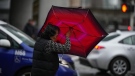
Over the last day, Environment Canada issued special weather statements that stretched from Whistler to Maple Ridge, with large amounts of precipitation forecast for the region.
The weather agency said a frontal system was expected to cross the South Coast on Friday, bringing rain and snow to the Sea to Sky corridor. The temperatures were forecast to warm throughout the morning with possible rain showers for the Squamish area in the afternoon.
Environment Canada is also reporting that parts of Metro Vancouver could see snow at higher elevations, especially on the North Shore, as the system passes through.
The temperatures are forecast to jump in the Lower Mainland turning any flurries into showers.
Metro Vancouver measured the local snowpack at around 50 per cent of its normal levels which is a 20 per cent increase from just a week ago.
Heidi Walsh, the watershed and environment director for Metro Vancouver, told CTV News that the additional snow is crucial as it supplies the region with a stash to fill reservoirs in the case of drought like conditions.
“As spring progresses we will be watching to see if we’re seeing a drying trend again, and then, that will help us decided if we need to enhance our watering restrictions,” said Walsh earlier this week.


CTVNews.ca Top Stories
Hurricane-force winds hitting parts of the B.C. coast as 'bomb cyclone' develops
Hurricane-force winds of more than 120 km/h are hitting parts of the British Columbia coast as a "bomb cyclone" develops off Vancouver Island.
Two undersea cables in Baltic Sea disrupted, sparking warnings of possible ‘hybrid warfare’
Two undersea internet cables in the Baltic Sea have been suddenly disrupted, according to local telecommunications companies, amid fresh warnings of possible Russian interference with global undersea infrastructure.
Sitting too much linked to heart disease –– even if you work out, according to new study
Sitting at your desk all day may put you at greater risk for heart disease –– even if you work out in your spare time, according to new research.
'Embarrassed': NDP MP calls on Randy Boissonnault to resign over false Indigenous claims
A Métis member of Parliament is calling on the employment minister to resign over what he calls harmful false claims to Indigenous ancestry.
Calgary doctor charged with sexual assault of multiple patients
A Calgary doctor is facing charges after allegedly sexually assaulting four patients between 2016 and 2020. Police say all four victims came forward independently in 2023 to report their alleged assaults.
Swiftie's friendship bracelet beads confiscated at Calgary airport
A Canadian Taylor Swift fan has some 'Bad Blood' with the Calgary International Airport after security staff confiscated hundreds of dollars worth of beads she was going to use to make friendship bracelets.
Sarah McLachlan cancels anniversary tour due to health concerns
Sarah McLachlan fans will be saddened to learn the famed Canadian singer has cancelled her 30th anniversary “Fumbling Towards Ecstasy” tour due to health concerns.
Trump chooses TV doctor Mehmet Oz to lead Centers for Medicare and Medicaid Services
President-elect Donald Trump on Tuesday tapped Dr. Mehmet Oz, a former television talk show host and heart surgeon, to head the agency that oversees health insurance programs for millions of older, poor and disabled Americans.
'I'm just tickled pink': Two childhood friends from New Brunswick named Rhodes Scholars
Two young women from New Brunswick have won one of the most prestigious and sought-after academic honours in the world.
Shopping Trends
The Shopping Trends team is independent of the journalists at CTV News. We may earn a commission when you use our links to shop. Read about us.


Vancouver Island
-
Hurricane-force winds hitting parts of the B.C. coast as 'bomb cyclone' develops
Hurricane-force winds of more than 120 km/h are hitting parts of the British Columbia coast as a "bomb cyclone" develops off Vancouver Island.
-
Strong winds, downed trees force closure of Vancouver Island highway
An almost 40 kilometre stretch of Highway 4 on Vancouver Island was closed Tuesday evening due to the impacts of a storm that forecasted to batter the South Coast.
-
BC Ferries cancels sailings on major routes due to incoming storm
BC Ferries has cancelled Tuesday evening's sailings between the Lower Mainland and Vancouver Island in anticipation of an incoming storm.
Kelowna
-

Man in hospital following targeted shooting in Kamloops
Police are appealing for information on a targeted shooting that resulted in the hospitalization of a man in Kamloops.
-
Police cleared of fault in fatal 2023 crash in B.C.'s Interior
British Columbia's independent police watchdog has cleared officers of wrongdoing in a crash where three people were killed south of Kamloops in July of last year.
-
B.C. woman sentenced for stealing $14K in funds raised for schoolkids
A B.C. woman who stole more than $14,000 in volunteer-raised funds that were supposed to be spent on school supplies and programs – including hot meals for vulnerable kids – won't spend any time in jail.
Edmonton
-

Scammers have stolen more than $37M in Edmonton this year. Here's how
From text messages to phone calls and in-person interactions, scam artists are trying to con you out of your money.
-
Oilers end road trip with win over Senators
After a shutout loss the night before, the Edmonton Oilers bounced back on Tuesday with a convincing 5-2 victory over the host Ottawa Senators.
-
Developer makes plea to Alberta government to reconsider plan to demolish old museum
An Edmonton property developer known for reimaging old buildings says it's bewildered the Alberta government has moved ahead with a plan to tear down the former provincial museum.
Calgary
-

Calgary doctor charged with sexual assault of multiple patients
A Calgary doctor is facing charges after allegedly sexually assaulting four patients between 2016 and 2020. Police say all four victims came forward independently in 2023 to report their alleged assaults.
-
Calgary police, fire make pitches to city council during mid-cycle budget talks
The Calgary Police Commission is proposing to use money earmarked for community crisis and mental-health groups to fund a new firearms range, unless the city offers up more in its budget.
-
Swiftie's friendship bracelet beads confiscated at Calgary airport
A Canadian Taylor Swift fan has some 'Bad Blood' with the Calgary International Airport after security staff confiscated hundreds of dollars worth of beads she was going to use to make friendship bracelets.
Lethbridge
-

Corb Lund turns up volume over proposed coal mining in Crowsnest Pass area
On Tuesday night, Alberta country music star Corb Lund used his platform to turn the volume up on the issue, just as Crowsnest Pass residents voted on whether they want coal mining in their backyard.
-
First snowfall in Lethbridge causes headaches for drivers
Lethbridge awoke to its first snowfall of the season on Tuesday. It was only a few centimetres, but it left many Lethbridge roads icy. Much of it melted in the afternoon.
-
Lethbridge police advise of changes amid Canada Post workers strike
The ongoing Canada Post workers strike is affecting the ability of many to go about their day-to-day, Lethbridge Police Service included.
Winnipeg
-

Police say threat resolved after report of man with knife at University of Manitoba
An incident involving reports of a man armed with a knife at the University of Manitoba Fort Garry Campus has been resolved according to Winnipeg police.
-
Blowing snow, poor visibility forcing road closures
A winter storm rolling into southwestern Manitoba is bringing dangerous driving conditions with it.
-
Blizzard conditions met migrants at Manitoba-Minnesota border crossing, trial hears
Witnesses have testified about brutal cold along the border between Manitoba and Minnesota, where a family from India froze to death in early 2022 while trying to walk into the United States.
Regina
-

Sask. experiences first snowfall of the winter season, conditions affecting travellers
Since Monday night, snow has been falling in Saskatchewan in many areas throughout the province. This has caused chaos both on the roads for drivers and those passengers travelling by air.
-
Indigenous elders, archaeologists, scholars come together to explore significant sites
A group of Indigenous elders, archaeologists and scholars have come together to explore historically significant sites pertaining to Indigenous ancestry.
-
Provincial emergency alert test scheduled for Wednesday
Those in Saskatchewan may get an alert on their cell phones, TV, and radio Wednesday afternoon as part of a provincial emergency alert test.
Saskatoon
-

Saskatoon medical aesthetics business closes, leaving clients out thousands
Clients of a medical aesthetics business in Saskatoon are left waiting for any indication their pre-bought services will be fulfilled after the business closed permanently.
-
'Nowhere to go': Saskatoon community groups rise to offer warm shelter as temperatures plummet
As Saskatoon buckles down for winter, the staff at Prairie Harm Reduction gears up for the influx of people through their doors.
-
Saskatoon clearing priority streets after first major snowfall
Saskatoon residents woke to find the city under a blanket of snow on Tuesday, with around 10 centimetres falling overnight and more on the way.
Toronto
-

Man charged with attempted murder after one person shot while trying to stop Mississauga home invasion
A 28-year-old man has been arrested in connection with armed home invasions in Mississauga, Toronto, and Brampton, including one incident where one person was shot and seriously injured.
-
Here are the most stolen vehicles in Ontario in 2023
The Lexus RX has topped this year’s list of the most stolen vehicles in Ontario as the auto theft crisis continues to worsen across the province and country.
-
Premier Ford says Toronto's estimate of bike lane removal cost 'bunch of hogwash'
Ontario Premier Doug Ford says the City of Toronto’s early estimate of the cost to remove three major bike lanes is 'a bunch of hogwash.'
Montreal
-

Montreal rally marks 1,000 days of war in Ukraine
A crowd gathered in downtown Montreal on Tuesday to mark the 1,000 days since the start of the war in Ukraine.
-
Quebec agrees to delay dismantling of homeless encampment in east Montreal
The dismantling of a homeless encampment this week in Montreal's east end has been averted — for now.
-
Montreal wants assault weapons banned before buy back program starts
Mayor Valerie Plante is urging the federal government to implement wider gun control measures by banning all assault weapons before Canada starts its buy back program.
Ottawa
-

Five people injured, including firefighter, after garage fire in South Keys
A firefighter was taken to hospital in stable condition and four others were treated for smoke inhalation after fire on Southgate Rd.
-
Federal land in Ottawa's west end now available for housing
The federal government is making a piece of land available for future housing in Ottawa's west end, on land around the historic building that houses a Keg Restaurant.
-
Ottawa restaurant claims spot on Canada's top 100 list
A cozy dining spot in Ottawa's Little Italy has cracked OpenTable's top 100 restaurants in Canada for 2024.
Atlantic
-

Cape Breton man's disappearance now ruled a homicide
Police in Cape Breton are now treating the disappearance of Kenneth “Justin” MacDonald as a homicide.
-
N.S. teacher previously charged with sexual offences with student facing new charges for breaching conditions: RCMP
The RCMP in Nova Scotia says a teacher who was previously charged for sexual offences with a student is facing new charges after contacting a youth victim.
-
Residents worried after mistaken emergency alert at NSCC campus in Truro
A mistaken alert from a college in Truro, N.S., left some residents and students in the area worried.
London
-

'The word Labatt is missing': Sign stolen from entrance to Labatt Park
The entrance to Labatt Park looks a little different after thieves stole part of the metal sign.
-
City seeks feedback from residents in subdivisions under construction
If you live in a neighbourhood that’s still under construction, you may not realize that most of the basic city services are the responsibility of the developer, as opposed to the city itself.
-
Road closures for BRT work in London
Work on the BRT traffic lights will result in some overnight lane closures in London.
Kitchener
-

Mother says spreading kindness is helping her heal after son’s tragic death
The mother of a man who was fatally shot in Cambridge is marking the painful anniversary of his death by giving to others.
-
'Doors shaking from bombing': Ukrainian refugee living in Kitchener looks back at 1,000 days of Ukraine-Russia war
A Ukrainian, now living in Kitchener, describes what life is like back home and what she's doing to help her fellow refugees.
-
When will we see the first snow of the season?
The first snowfall of the season could come this week – but don’t worry, it won’t be sticking around.
Northern Ontario
-

'Embarrassed': NDP MP calls on Randy Boissonnault to resign over false Indigenous claims
A Métis member of Parliament is calling on the employment minister to resign over what he calls harmful false claims to Indigenous ancestry.
-
Drinking water advisory issued for certain streets in Greater Sudbury
People living on Morris Street east of Van Horne and all streets leading off Morris in Greater Sudbury are under a drinking water advisory, the health unit said Tuesday.
-
Seven-month road construction project comes to an end in Timmins
The City of Timmins is putting the final touches on Algonquin Boulevard East, between Balsam Street and Brunette Road.
N.L.
-

Newfoundland wind-to-hydrogen company eyes data centre as international market lags
A company hoping to build a multi-billion-dollar wind-to-hydrogen project in western Newfoundland is eyeing other options as Canada's plans to supply Europe with green energy have not yet materialized.
-
Seniors face unique hurdles in finding love. These Canadians want to help.
The four women sipping tea around an antique wooden table in rural Newfoundland said they weren't looking for much in a mate: kindness, humour, a good sense of fun and, ideally, a full set of teeth.
-
English soccer game did not deliver such a big bounce for N.L. after all: province
Newfoundland and Labrador's return on investment for sponsoring a professional English soccer team was not quite as rosy as previously claimed.


