Parts of the Lower Mainland, Vancouver Island and the southern Gulf Islands may be pelted with hail as a Pacific storm system heads north from the U.S., Environment Canada warns.
The weather agency has issued a severe thunderstorm watch for a swath of the province spanning from Vancouver up to the Shuswap area.
The watch applies to Metro Vancouver, Howe Sound, Whistler, the Fraser Valley, Similkameen, Fraser Canyon, Nicola, North and South Thompson, 100 Mile House and North Columbia.
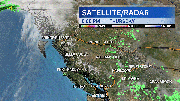
Environment Canada warns that a Pacific cold front is expected to pass over the southern part of the province Thursday evening, carrying with it atmospheric conditions that can lead to thunderstorms. While the front's path covers much of the South Coast, the potential for thunderstorms will be most severe specifically in Metro Vancouver, the Fraser Valley, Howe Sound and Whistler.
The main threat is high winds and heavy downpours – likely to cause flash floods and water pooling – but meteorologists warned that large hailstones are possible. "Intense lighting" is also likely if thunderstorms develop.
Greater Victoria and the southern Gulf Islands may also see thunderstorms, though Environment Canada has only issued a statement for the areas above. Residents of those regions can expect localized heavy downpours of between 15 and 25 millimetres of rain, with a risk of hail beginning early this evening and ending "sometime overnight."
Parts of the province are also under special weather statements that warn that the heavy rain coupled with melting snow packs may cause rising rivers and flooding.
Distant lightning in slo-mo from last night's storm taken from #CTVChopper9 @taloncopters @ctv pic.twitter.com/YJVRjBE763
— Pete Cline (@yvrnewsphotog) May 5, 2017
A few screen caps of last night's lightning as seen from @CTVVancouver chopper9 pic.twitter.com/n1OBalPa7d
— Pete Cline (@yvrnewsphotog) May 5, 2017
A few more screen caps of last night's lightning and storm as seen from @CTVVancouver chopper9 pic.twitter.com/tsYeAfFZAx
— Pete Cline (@yvrnewsphotog) May 5, 2017
Storm's a brewing in Olympic Village!What's happing in your area? @CTVVancouver pic.twitter.com/Kxt7sK51pr
— Ann Luu (@ann_luu) May 5, 2017