
Emergency crews in the Okanagan are preparing for potentially severe flooding as water levels in Okanagan Lake approach an all-time high.
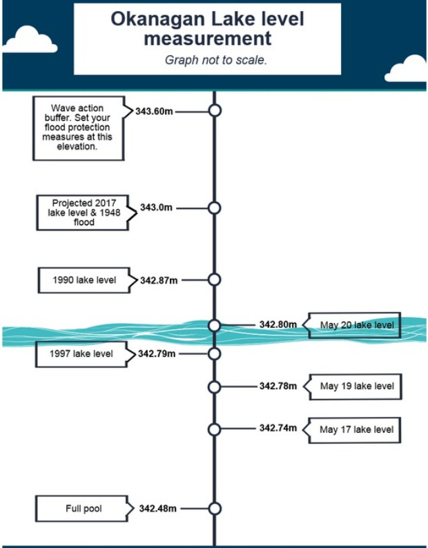
According to a graphic released by Central Okanagan Emergency Operations, water levels in the lake are currently a at 342.8 metres—slightly surpassing 1997 flood levels. That means the lake now sits just 22 centimetres below flooding level.
Water levels are expected to rise at least another 20 centimetres to 343 metres.
In a statement released Saturday, COEO officials urged boaters to stay off the water this weekend.
Temperatures in the mid to high 20s have melted the snow on the surrounding mountains causing a rapid increase the lake’s water level.
Flooding has lifted trees, branches and other debris into the lake, making the body of water hazardous to navigate.
Those who do access Okanagan Lake by boat are asked to drive slowly, stay away from the shore and to avoid certain areas due to high water and wave action.
Crews have been sandbagging and installing portable dikes in the area for the past week and are continuing flood mitigation efforts over the long weekend.
Officials are warning the public against visiting the following areas on Okanagan Lake:
Peachland
- The entire downtown waterfront; specifically, Heritage Park to Buchanan
- All day use docks and wharfs (closed)
- Princeton boat launch (closed)
West Kelowna
- Green Bay area
- Casa Loma area
- Pritchard Drive area
- Whitworth Road area
Lake Country
- Tween Lakes (canal) and entire Oyama isthmus area
- Carrs Landing
- Okanagan Centre
- Turtle Bay
Westside Road (RDCO)
- Wilson’s Landing
- Fintry area
- Killiney Beach area
Kelowna
- The entire waterfront between Poplar Point and Cedar Creek


