B.C. drought: More than 20 temperature records broken ahead of long weekend
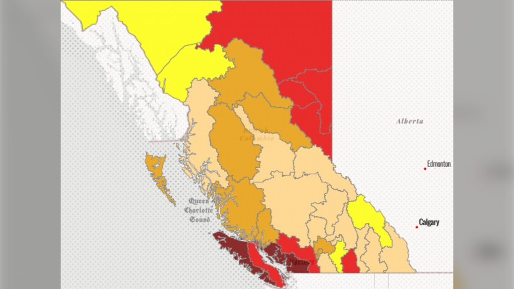
 Drought conditions in B.C. as of Oct. 7, 2022. (Province of BC)
A drought and unseasonably warm weather persisting across B.C. led to more temperature records breaking in the province Thursday.
Environment Canada's preliminary data for Oct. 6 shows another 21 records were broken in communities across the province. Many of the records were decades old, including one that was set nearly a century ago.
In 1925, Bella Coola recorded a high temperature of 22.8 C on Oct. 6. But this year, it got as hot as 24.3 C.
Some parts of the province are rated at Level 5 for drought conditions as of Friday morning, which means adverse impacts are "almost certain." Those regions include the Lower Mainland, Sunshine Coast and West Vancouver Island. Seven other regions are at Level 4, meaning adverse impacts are "likely."
Meteorologists with Environment Canada warned earlier in the week the province could continue seeing this hot, dry weather pattern for several days.
"We've been stuck in this (weather) pattern for quite some time," Bobby Sekhon with Environment Canada told CTV News Vancouver.
"It's possible that into early next week we might see a bit of a shift in the pattern."
Metro Vancouver's forecast for the week ahead shows mostly sun, with highs hovering around 20 C. Monday could be a little cooler, however, and may see some rain.
Other temperature records broken Thursday, according to Environment Canada's preliminary data, include:
- Abbotsford area – new record of 27.2 C, old record of 26.7 C set in 1952.
- Agassiz area – new record of 29.6 C, old record of 26.7 C set in 1942.
- Bella Bella area – new record of 20.6 C, old record of 18.5 C set in 2012.
- Burns Lake area – new record of 21.5 C, old record of 20.7 C set in 2012.
- Chilliwack area – new record of 29.2 C, old record of 27.8 C set in 1952.
- Clearwater area – new record of 23.8 C, old record of 22 C set in 2003.
- Comox area – new record of 22.3 C, old record of 21.2 C set in 1980.
- Courtenay area – new record of 22.3 C, old record of 21.2 C set in 1980.
- Gibsons area – new record of 21.9 C, old record of 20.7 C set in 2012.
- Hope area – new record of 30.3 C, old record of 27.8 C set in 1943.
- Lilloeet area – new record of 28.1 C, old record of 28 C set in 1980.
- Malahat area – new record of 23.7 C, old record of 23.5 C set in 1987.
- Pemberton area – new record of 27.2 C, old record of 23.7 C set in 2012.
- Pitt Meadows area – new record of 26.1 C, old record of 24 C set in 1978.
- Powell River area – new record of 21.9 C, old record of 21.1 C set in 1964.
- Sechelt area – new record of 21.9 C, old record of 20.7 C set in 2012.
- Squamish area – new record of 29.5 C, old record of 25.5 C set in 1987.
- Tatlayoko Lake area – new record of 24.1 C, old record of 23.9 C set in 1936.
- Vernon area – new record of 24.1 C, old record of 24 C set in 1980.
- Whistler area – new record of 24.8 C, old record of 22.1 C set in 1980.
CTVNews.ca Top Stories

Finland stops Russia-linked vessel over damaged undersea power cable in Baltic Sea
Finnish authorities detained a ship linked to neighboring Russia as they investigate whether it damaged a Baltic Sea power cable and several data cables, police said, in the latest incident involving disruption of key infrastructure.
DEVELOPING Body found in wheel well of plane at Maui airport
A person was found dead in the wheel well of a United Airlines flight to Maui on Tuesday.
Raised in Sask. after his family fled Hungary, this man spent decades spying on communists for the RCMP
As a Communist Party member in Calgary in the early 1940s, Frank Hadesbeck performed clerical work at the party office, printed leaflets and sold books.
Police in New Brunswick investigating Christmas Eve sudden death
An unconscious individual was found in the 600-block area of Lancaster Avenue early Christmas Eve morning, and was later pronounced dead at a hospital.
Aviation experts say Russia's air defence fire likely caused Azerbaijan plane crash as nation mourns
Azerbaijan on Thursday observed a nationwide day of mourning for the victims of the plane crash that killed 38 people and left all 29 survivors injured as speculation mounted about a possible cause of the disaster, with some experts saying that the airliner was damaged by Russian air defence fire.
Police identify victim of Christmas Day homicide in Hintonburg, charge suspect
The Ottawa Police Service says the victim who has been killed on Christmas Day in Hintonburg has been identified.
Your kid is spending too much time on their phone. Here's what to do about it
Wondering what your teen is up to when you're not around? They are likely on YouTube, TikTok, Instagram or Snapchat, according to a new report.
Bird flu, measles top 2025 concerns for Canada's chief public health officer
As we enter 2025, Dr. Theresa Tam has her eye on H5N1 bird flu, an emerging virus that had its first human case in Canada this year.
Ship remains stalled on St-Lawrence River north of Montreal
A ship that lost power on the St. Lawrence River on Christmas Eve, remains stationary north of Montreal.


