
The United States Geological Survey has identified what it calls four high-risk volcanoes in Washington state, but there are others even closer to home that aren’t being monitored at all.
Glyn Williams-Jones, a professor at Simon Fraser University’s earth sciences department, said the Canadian government needs to start tracking volcanic activity.
“We want to have baseline information. We want to look at that volcano when it is doing nothing and know what is normal,” the volcanologist said. “If we’re not looking properly, then we won’t see the tell-tale signs.”
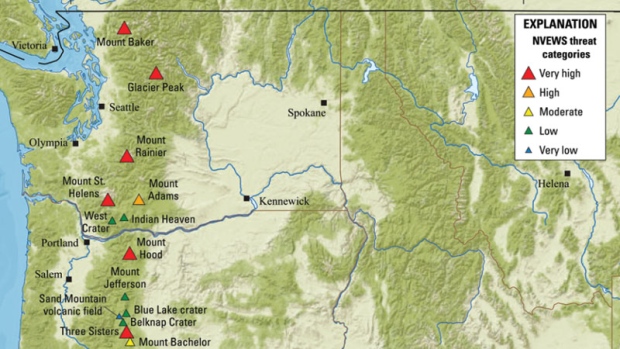
According to the USGS’s volcanic threat assessment, Mt. St. Helens and Mt. Rainier took the second and third spots as having “very high threat.”
Mt. Baker, which is closest to the Lower Mainland, was ranked 14th.
The ranking is based on 15 factors, including how many people would be at risk, the type of danger a volcano poses and how much knowledge experts have on the respective volcanoes.
“Volcanoes don’t care about borders. It could be mud flows or volcanic ash—they do sometimes have a global impact,” Williams-Jones said.
He pointed to the Icelandic volcano ash crisis of 2010 which grounded flights for about a week and cost the aviation sector up to US$3.3 billion.
The eruption of the Eyjafjallajokull volcano was relatively small, but it created a troublesome ash cloud that limited visibility for pilots and a risk of debris being sucked into airplane engines.
Many British Columbians remember the St. Helens blast of 1980, which sent ash hundreds of kilometres away and killed dozens of people.
Earthquakes are the primary concern: public safety minister
The closest volcano to the Greater Vancouver area is Mount Baker, which is classified as a very high threat volcano.
B.C.’s Public Safety Minister Mike Fanworth said officials rely on their American counterparts to notify the province before deploying its emergency procedures. He admits the province’s priorities are monitoring seismic activity.
“Mt. Baker is the biggest threat to us in terms of a volcano. Obviously there are other geological forces that are of considerable concern to B.C. is primarily earthquakes. And this in area, as we know, is overdue for a major earthquake,” he said.
Williams-Jones said Baker does not need to have a large explosion to devastate people in the Lower Mainland. He explained there is a large volume of ice and snow that could easily melt, triggering a lahars, which he describes is like a river of concrete.
“They’re incredibly erosive, fast-moving. They flow down the river valleys and if they go down the wrong one, it could impact the Nooksack and have secondary impacts on Abbotsford,” Williams-Jones said.
Those impacts would negatively affect fisheries and may cause secondary flooding.
B.C. has a dozen volcanoes
There are at least 12 volcanoes in B.C., including Mt. Garibaldi and Mt. Meager, a young, active one that could send ash across provincial borders.
Mt. Meager, which is in the Squamish-Lillooet area, last erupted roughly 2,400 years ago and at that time, sent volcanic ash as far away as Calgary, Williams-Jones explained.
The volcano appears to be less stable in recent years.
“Mt. Meager is currently degassing through the ice pack, that’s in part related to changing climate,” he said.
Williams-Jones admits studying volcanoes on this side of the border is extremely difficult because many of them are remote and expensive to reach.
On the other hand, they tend to pose less of a threat for that very reason. But history has shown, the impacts of volcanoes can be far-reaching.
“I hope we don’t have our own St. Helens because that’s too late,” Williams-Jones said.
With files from CTV’s St. John Alexander and The Associated Press


