Metro Vancouver's snowfall warning lifted, winter storm watch predicts 20 cm possible this week
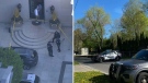
 Ice floes are seen on the Fraser River as a Skytrain crosses over the river in New Westminster, B.C., on Tuesday, December 28, 2021.
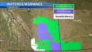
More snow may be on the way this week for Metro Vancouver as a new winter storm watch predicts as much as 20 centimetres could accumulate in some areas.
The latest weather advisory was issued late Tuesday morning due to a low-pressure system heading to B.C.'s coast Wednesday evening. Environment Canada said "rapidly accumulating snow" and freezing rain could affect the morning commute Thursday.
Between 10 and 20 centimetres is expected late Wednesday through Thursday.
Meanwhile, a snowfall warning issued for Metro Vancouver Tuesday morning urged commuters to prepare for heavy flurries throughout the day. That snowfall warning was lifted before noon, however.
"Rapidly accumulating snow could make travel difficult over some locations. Travel is expected to be hazardous due to reduced visibility in some locations," Environment Canada said in its latest advisory.
"Surfaces such as highways, roads, walkways and parking lots may become icy and slippery. There may be a significant impact on rush hour traffic in urban areas."
Elsewhere in B.C., temperatures could feel as low as -50 C. Environment Canada said Tuesday a very cold air mass stretches across parts of Yukon and northern, northeastern and southeastern B.C., with marginal improvement expected by Wednesday when winds are forecast to ease slightly.
Last week, Metro Vancouver saw record-breaking low temperatures in some cities and a significant amount of snow.
By the weekend, Vancouver's forecast predicts it could get as warm as 7 C.
With files from The Canadian Press


CTVNews.ca Top Stories
Canada Disability Benefit needs to safeguarded from clawbacks, MPs unanimously agree
The federal government needs to safeguard the incoming Canada Disability Benefit from clawbacks and do more to ensure it actually meets the stated aim of lifting people living with disabilities out of poverty, MPs from all parties agree.
BREAKING
BREAKING Security guard shot, seriously injured outside of Drake's Toronto mansion
A security guard working at Drake’s Bridle Path mansion in Toronto was seriously injured in a shooting outside the residence early Tuesday morning, police said.
King Charles too busy to see son Prince Harry during U.K. trip
Prince Harry will not be seeing his father King Charles during his current visit to Britain as the monarch will be too busy, Harry's spokesperson said on Tuesday.
opinion
opinion Tom Mulcair: Turfing Poilievre from House a clear sign of desperation by Trudeau Liberals
When Speaker Greg Fergus tossed out Pierre Poilievre from the House last week, "those of us who have experience as parliamentarians simply couldn't believe our eyes," writes former NDP leader Tom Mulcair in his column for CTVNews.ca
Your body needs these three forms of movement every week
Movement is movement, right? Not exactly. Here’s what your body is looking for in addition to your morning walk or yoga session, according to experts.
Six Canadian children repatriated from detention in Syria, Global Affairs Canada says
The Global Affairs Department says six Canadian children have been repatriated from detention in northeastern Syria.
'It looked so legit': Ontario man pays $7,700 for luxury villa found on Booking.com, but the listing was fake
An Ontario man says he paid more than $7,700 for a luxury villa he found on a popular travel website -- but the listing was fake.
Quebec to limit sperm donations per donor after 3 men from same family father hundreds of children
Quebec is looking at tightening the regulations around sperm donation in the province following the release of a documentary that revealed three men from the same family fathered hundreds of children.
Canadian cadets rock mullets and place second at U.S. military competition
Sporting mullets, Canadian Armed Forces officer cadets placed second in an annual military skills competition in the U.S.
Shopping Trends
The Shopping Trends team is independent of the journalists at CTV News. We may earn a commission when you use our links to shop. Read about us.


Vancouver Island
-

Victoria the only city to pass B.C. home-building target so far
Under the province’s new housing targets, Victoria was tasked with creating 659 new units within the first year. It has hit 753 in six months.
-
3 Indian nationals accused of murdering Hardeep Singh Nijjar facing court in B.C.
Three Indian nationals accused of murdering Sikh activist Hardeep Singh Nijjar are due to face court Tuesday over the killing that triggered a major diplomatic rift with India.
-
Ongoing fireworks in B.C. legislature over drug decriminalization
Tempers flared in B.C.'s legislature Monday, fanned by the issue of decriminalization in the province as BC United and the BC Conservatives took aim at the controversial policy.
Kelowna
-

Red dresses to make fashion statement about missing and murdered Indigenous women
Models in uniquely designed red dresses are taking to the runway in British Columbia this weekend to make a powerful fashion statement about missing and murdered Indigenous women, girls and two-spirit people.
-
B.C. breweries take home awards at World Beer Cup
Out of more than 9,000 entries from over 2,000 breweries in 50 countries, a handful of B.C. brews landed on the podium at the World Beer Cup this week.
-
B.C. man rescues starving dachshund trapped in carrier: BC SPCA
An emaciated dachshund is now recovering thanks to a Good Samaritan who found the pup near a biking trail in Kelowna, according to the BC SPCA.
Edmonton
-

Oilers captain McDavid named Hart finalist along with MacKinnon, Kucherov
Edmonton Oilers captain Connor McDavid was named a finalist for this year's Hart Trophy on Tuesday as he seeks to win the NHL's most valuable player award for a second straight season.
-
Alberta UCP facing growing pushback following introduction of municipalities bill
It was a long time ago, but Jan Novotny still remembers the tanks rumbling through his hometown of Prague in 1968 when the Soviet Union enforced its will on the people of what was then Czechoslovakia.
-
Canadian goalkeeper Stephanie Labbe gets vulnerable in new documentary
Former Canadian goalkeeper Stephanie Labbe is opening up in a new documentary called Shut Out.
Calgary
-
 WEATHER
WEATHER Cold, wet and windy – heavy, wet snow and up to 100 mm of rain possible in southern Alberta
An intense low pressure system of just 986 mb situated south of Saskatchewan will be the main weather maker in central and southern Alberta Tuesday.
-
Single-use items bylaw back before Calgary council amid repeal hearing
The public hearing required to officially repeal the city’s single-use items bylaw is being held Tuesday.
-
Here are the Calgary Flames' 2024 Draft Lottery odds
The Calgary Flames will learn where they are picking in the 2024 National Hockey League (NHL) Draft on Tuesday afternoon.
Lethbridge
-
Lethbridge police seek suspects in 'street robbery'
Lethbridge police are looking for two people they believe were involved in the 'street robbery' of a senior last week.
-
Southern Alberta animal shelters overrun with abandoned pets
Animal shelters across the province are finding themselves frequently at capacity -- or more.
-
Woman charged in connection with fatal crash
Lethbridge police say impaired driving is to blame in a fatal crash that killed a 25-year-old man on Thursday.
Winnipeg
-

Loblaws boycott arrives in Winnipeg
Fed up with the ever rising price of food, an online movement has sprung up to fight back in the form of a boycott.
-
Winnipeg man admits to killing four women, argues he's not criminally responsible
Defence lawyers of Jeremy Skibicki have admitted in court the accused killed four Indigenous women, but argues he is not criminally responsible for the deaths by way of mental disorder – this latest development has triggered a judge-alone trial rather than a jury trial.
-
'A big concern for us': Virologist on danger of avian flu outbreak coming to Canadian cattle
A Canadian virologist says an avian flu outbreak decimating wildlife in the United States should give us pause on this side of the border.
Regina
-

Regina police officer who was accidentally shot facing 'life changing injuries'
Regina police say the officer who was accidentally shot by a fellow officer's gun last month suffered 'serious and life changing injuries,' adding he has a 'very' long road to recovery.
-
WEATHER
WEATHER Sask. rainfall warnings still in effect, recorded totals highest in south
Rainfall warnings remain in effect for southwest Saskatchewan Tuesday morning with the highest amounts recorded in the province’s south-central and southwest.
-
Sask. NDP criticizes nearly $1 million spent on former Prime Minister's consulting firm
The Government of Saskatchewan has paid former Prime Minister Stephen Harper's consulting firm nearly $1 million over the past four years for trade advice. The opposition says it has been blocked while trying to gather more details on the contract.
Saskatoon
-

'What you dream about': Blades, Warriors prepare for game 7 of WHL's east final
The Saskatoon Blades and Moose Jaw Warriors will take to the ice for game seven Tuesday night to determine who will book their ticket to the Western Hockey League’s [WHL] final.
-
The lone road into this Sask. village is so bad some locals drive through the ditch
Aaron Fosseneuve says the official name of the road into his home community of Cumberland House is Highway 123, but locals joke it’s not as easy as 1-2-3 — “it’s more like a 4-5-6.”
-
Police say Sask. man assaulted hospital staff the night before killing his mother
Prince Albert police say a 29-year-old man charged in the murder of his mother had assaulted a staff member at Victoria Hospital the night before the killing.
Toronto
-
 BREAKING
BREAKING Security guard shot, seriously injured outside of Drake's Toronto mansion
A security guard working at Drake’s Bridle Path mansion in Toronto was seriously injured in a shooting outside the residence early Tuesday morning, police said.
-
'It looked so legit': Ontario man pays $7,700 for luxury villa found on Booking.com, but the listing was fake
An Ontario man says he paid more than $7,700 for a luxury villa he found on a popular travel website -- but the listing was fake.
-
Toronto investigating after dead fish found floating in High Park pond
The City of Toronto is investigating after a large number of dead fish were found floating in Grenadier Pond in High Park.
Montreal
-

Quebec to limit sperm donations per donor after 3 men from same family father hundreds of children
Quebec is looking at tightening the regulations around sperm donation in the province following the release of a documentary that revealed three men from the same family fathered hundreds of children.
-
Montreal police, prosecutors launch project to better address strangulation cases
Montreal police and the Quebec prosecutor's office are launching a pilot project to help authorities better address domestic violence-related strangulations.
-
BREAKING
BREAKING Security guard shot, seriously injured outside of Drake's Toronto mansion
A security guard working at Drake’s Bridle Path mansion in Toronto was seriously injured in a shooting outside the residence early Tuesday morning, police said.
Ottawa
-
 BREAKING
BREAKING Travis Green to be head coach of the Ottawa Senators
Travis Green, 53, is the new head coach of the Ottawa Senators.
-
Homebuilders issue warning about proposed $12,000 hike in Ottawa development charges
The Greater Ottawa Home Builders Association warns a $12,000 increase in development charges on new homes will create an unexpected cost for homebuyers planning to buy a new home in Ottawa this year.
-
Drivers could face mandatory alcohol screening during traffic stops in Ottawa, police warn
Ottawa police warn drivers pulled over for a traffic stop may be asked to provide a breath sample, as the service continues to see a rise in impaired drivers on the roads.
Atlantic
-

2 dead after boat capsizes in Annapolis River; N.S. RCMP believes alcohol a factor
Two Nova Scotia men are dead after a boat they were travelling in sank in the Annapolis River in Granville Centre, N.S., on Monday.
-
Crash between pickup truck, motorcycle leaves 1 man dead: N.S. RCMP
A 20-year-old man has died following a collision between a pickup truck and motorcycle in Union Corner, N.S., on Sunday.
-
IWK looking for missing 17-year-old patient
The IWK Health Centre in Halifax is looking for a 17-year-old patient who has gone missing.
London
-
BREAKING
BREAKING Security guard shot, seriously injured outside of Drake's Toronto mansion
A security guard working at Drake’s Bridle Path mansion in Toronto was seriously injured in a shooting outside the residence early Tuesday morning, police said.
-
A roundup of a different kind for Huron OPP
Officers in Central Huron helped a local resident round up a sow and her piglets.
-
Highway 401 reopens after two separate crashes
Two unrelated crashes caused slowdowns on Highway 401 Tuesday morning.
Kitchener
-

$9M in drugs seized by WRPS, two Kitchener residents charged
Two Kitchener residents are facing charges in what police are calling one of the largest drug seizures in the Waterloo Regional Police Services’ (WRPS) history.
-
Breaking News
Breaking News Shots fired into residential building in Kitchener: WRPS
The Waterloo Regional Police Service (WRPS) is investigating after they say shots were fired into a residential building in Kitchener on Tuesday morning.
-
OPP urge safety as another wrong-way driver spotted on Highway 401
There have been two fatal wrong-way collisions on Highway 401 in the last week, and on Sunday, another driver was seen travelling in the opposite direction near Cambridge, Ont.
Northern Ontario
-
BREAKING
BREAKING Security guard shot, seriously injured outside of Drake's Toronto mansion
A security guard working at Drake’s Bridle Path mansion in Toronto was seriously injured in a shooting outside the residence early Tuesday morning, police said.
-
Man taken to Timmins hospital with gunshot wound after shooting on Sixth Avenue
People in Timmins are waking up to a heavy police presence and road closures in the area of Sixth Avenue and Pine Street on Tuesday morning.
-
'It looked so legit': Ontario man pays $7,700 for luxury villa found on Booking.com, but the listing was fake
An Ontario man says he paid more than $7,700 for a luxury villa he found on a popular travel website -- but the listing was fake.
N.L.
-

Newfoundland and Labrador latest province to tighten rules on Airbnbs
Newfoundland and Labrador is the latest jurisdiction to bring in stricter rules for short-term rentals, with a coming set of regulations that will force operators to register with the provincial government.
-
Officer convicted of on-duty rape no longer with Royal Newfoundland Constabulary
The Royal Newfoundland Constabulary says an officer convicted in 2021 of raping a woman while on duty is no longer with the force.
-
Evicted from St. John's, N.L. tent city, this man refuses bed in 'disgusting' shelter
A homeless man in Newfoundland says he refuses to sleep in a shelter after workers wearing balaclavas and haz-mat suits tore down a tent encampment in St. John's on Friday.


