Evacuation orders, flood warnings issued after landslide blocks B.C.'s Chilcotin River
A landslide in B.C.'s Central Interior blocked a major tributary of the Fraser River overnight Tuesday, prompting evacuation orders, flood warnings and an emergency alert on Wednesday.
The landslide occurred near Farwell Canyon, 18 kilometres southeast of Hanceville, and blocked the flow of the Chilcotin River, according to the flood warning issued by the B.C. River Forecast Centre Wednesday afternoon.
"This landslide has dammed the river and is creating a lake currently extending several kilometers upstream," the warning reads. "Higher water levels are expected along the Chilcotin River upstream of the dam."
The flood warning – which means "river levels have exceeded bankfull or will exceed bankfull imminently" and flooding "will result" – is in effect upstream of the landslide, but officials are warning there could be major consequences downstream, as well.
"The eventual overtopping of the landslide material may lead to sudden erosion of the debris and catastrophic failure of the landslide dam," the river forecast centre's warning reads.
"This could potentially cause an outburst flood downstream of the landslide. In this scenario, a surge of water would rapidly move down the Chilcotin River and into the Fraser River. Water levels could increase extremely quickly along the Chilcotin River as well as in the Fraser River immediately below the confluence. In the event of catastrophic failure, the flood surge could reach the Fraser River within hours, potentially traveling from the Chilcotin River to Hope within a day."
A flood watch – which means that "river levels are rising and will approach or may exceed bankfull" – is in effect downstream from the landslide and into the Fraser River as far as Hope.
Farther downstream, a high streamflow advisory – which means "river levels are rising or expected to rise rapidly, but that no major flooding is expected" – is in effect.
The river forecast centre says the Lower Mainland would see "less severe" effects from a catastrophic failure of the landslide dam, but may still experience "substantial increases in flow" on the Fraser River.
Emergency alert, evacuation orders
The provincial government issued an emergency alert Wednesday afternoon, advising all people and boaters anywhere along the banks of the Chilcotin and Fraser rivers from Hanceville to Hope to leave the area "immediately."
Earlier in the day, the Cariboo Regional District issued evacuation orders covering a total of 60 parcels with a combined area of 10,750 hectares – or more than 107 square kilometres – along the river.
The Tsilhqot'in National Government activated its emergency operations centre at "Level 1" and is "looking into the situation," according to a statement on the nation's website.
"Please avoid the Chilcotin River area due to danger of unpredictable water flow," the nation's statement reads.
The regional district issued its first evacuation order related to the incident shortly after noon. That order covered 34 parcels and more than 7,000 hectares, stretching from a few kilometres west of the Big Creek Ecological Reserve southeast to where the Chilcotin River joins the Fraser River.
The CRD issued a second evacuation order less than 90 minutes later. This one covered an additional 26 parcels and nearly 3,500 hectares, extending the evacuation zone west along the Chilcotin River to the Hanceville Bridge, just south of Highway 20 near Lee's Corner, B.C.
The regional district advised those in the evacuation zone to travel north to Highway 20 and east to Williams Lake.
"Due to immediate danger to life safety due to flooding caused by landslide, members of the RCMP or other groups will be expediting this action," the evacuation order reads.
"You must leave the area IMMEDIATELY. Persons who disregard this evacuation order and remain in the evacuation order area do so at their own risk."
Dog missing
Central Cariboo Search and Rescue said in a social media post that it was responding to "an injured individual and landslide west of Williams Lake" Wednesday morning.
In an update posted around 1 p.m., the SAR team said the injured man was in stable condition and had been transferred to the care of BC Emergency Health Services.
"The story that we got from the male was that he was rafting down the river – which is very common – and he had set up camp for the night, himself and his dog," explained Debra Bortolussi, CCSAR's public relations co-ordinator.
Around midnight, Bortolussi said, the man heard a rumbling and found himself running away from the landslide. He sustained his injuries while fleeing.
The man's raft got caught up in the debris and was visible from the SAR helicopter, according to Bortolussi.
She said the man's dog remains unaccounted for, but crews are "really hopeful" that the animal will be found.
What happens next?
Davide Elmo, a professor of rock engineering at UBC's Norman B. Keevil Institute of Mining Engineering, told CTV News the type of slide seen Wednesday is not unprecedented.
He said he found records of previous slides on the Chilcotin River that occurred in 1964 and 2004, with debris from the 1964 event eventually being recovered as far downstream as New Westminster.
The first step in remediating the damage caused by the slide will be to determine how stable the dam it created is, Elmo said. Is it solid enough for a person to stand on it? If so, what kind of machinery can be brought onto it?
The answers to those questions will determine the next steps that can be taken, the professor said, noting that safely creating an outlet to drain the lake forming behind the dam is a priority, if it's possible to do.
"You cannot simply just make any action until you know what kind of access you have to the body of the dam," Elmo said. "Based on that, they may actually decide, 'OK, let's build, basically, a canal to help as the water comes out of the reservoir that's being formed.'"
Such a canal would function similarly to a spillway on an artificial dam, allowing a more controlled and gradual release of water bypassing the dam structure itself.
With that kind of structure in place to manage the flow of water and bypass the dam, crews could actually go in and remove debris from the landslide safely, Elmo said.
If such an approach is not possible, or can't be achieved before the water in the newly formed lake overtops the dam, then the catastrophic failure scenario outlined in the river forecast centre's warning becomes more likely.
Elmo warned that a crack or hole in the dam itself could quickly erode as the water pushes through it.
"It's not, basically, 'Let's open up a hole and let the water drain,'" he said. "It's not that simple."
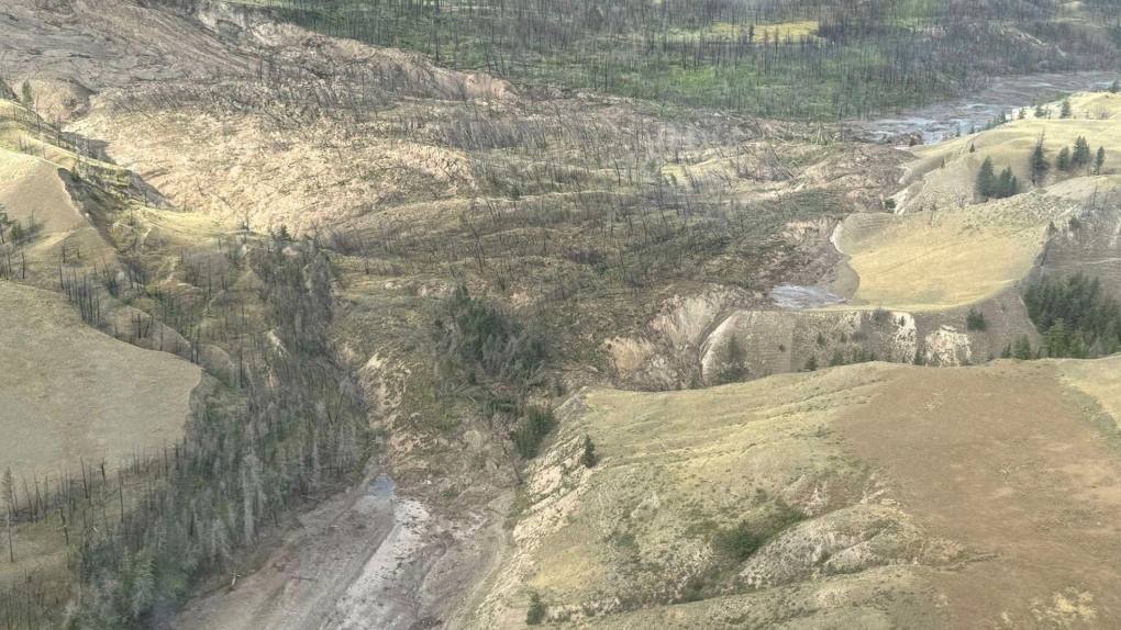 A photo shared by Central Cariboo Search and Rescue shows the scale of the landslide that blocked the Chilcotin River on Wednesday, July 31, 2024. (Facebook / Central Cariboo Search and Rescue)
Shopping Trends
The Shopping Trends team is independent of the journalists at CTV News. We may earn a commission when you use our links to shop. Read about us.


CTVNews.ca Top Stories

Mark Carney reaches out to dozens of Liberal MPs ahead of potential leadership campaign
Mark Carney, the former Bank of Canada and Bank of England governor, is actively considering running in a potential Liberal party leadership race should Justin Trudeau resign, sources tell CTV News.
'I gave them a call, they didn't pick up': Canadian furniture store appears to have gone out of business
Canadian furniture company Wazo Furniture, which has locations in Toronto and Montreal, appears to have gone out of business. CTV News Toronto has been hearing from customers who were shocked to find out after paying in advance for orders over the past few months.
WATCH
WATCH Woman critically injured in explosive Ottawa crash caught on camera
Dashcam footage sent to CTV News shows a vehicle travelling at a high rate of speed in the wrong direction before striking and damaging a hydro pole.
A year after his son overdosed, a Montreal father feels more prevention work is needed
New data shows opioid-related deaths and hospitalizations are down in Canada, but provincial data paints a different picture. In Quebec, drug related deaths jumped 30 per cent in the first half of 2024, according to the public health institute (INSPQ).
Rideau Canal Skateway opening 'looking very positive'
As the first cold snap of 2025 settles in across Ottawa, there is optimism that the Rideau Canal Skateway will be able to open soon.
Much of Canada is under a weather alert this weekend: here's what to know
From snow, to high winds, to extreme cold, much of Canada is under a severe weather alert this weekend. Here's what to expect in your region.
Jimmy Carter's funeral begins by tracing 100 years from rural Georgia to the world stage
Jimmy Carter 's extended public farewell began Saturday in Georgia, with the 39th U.S. president’s flag-draped casket tracing his long arc from the Depression-era South and family farming business to the pinnacle of American political power and decades as a global humanitarian.
'A really powerful day': Commemorating National Ribbon Skirt Day in Winnipeg
Dozens donned colourful fabrics and patterns Saturday in honour of the third-annual National Ribbon Skirt Day celebrated across the country.
Jeff Baena, writer, director and husband of Aubrey Plaza, dead at 47
Jeff Baena, a writer and director whose credits include 'Life After Beth' and 'The Little Hours,' has died, according to the Los Angeles County Medical Examiner.
Vancouver Island
-

Driver dead after collision with construction vehicle in Saanich, B.C.
A driver is dead after colliding with a construction vehicle in Saanich Friday night.
-
B.C. man ordered to pay damages for smashing Smart car window during road rage incident
A man who smashed the window of a woman’s Smart car during a road rage incident with a former co-worker has been ordered to pay $1,245 in damages by the B.C. Civil Resolution Tribunal.
-
WestJet denies compensation to Taylor Swift fan after flight cancellation
WestJet has denied compensation to a devout Taylor Swift fan whose cancelled flight triggered a 10-hour drive through the night from Prince George to make the singer's shows in Vancouver last month.
Kelowna
-

Lost skiers rescued off B.C. mountain
Search and rescue volunteers in B.C.’s Okanagan successfully reunited two skiers with their family Friday evening.
-
Charges laid after child porn investigation that 'spanned several different countries,' Kelowna RCMP say
Police in Kelowna say an international investigation has led to child pornography charges against a 46-year-old man.
-
Mounties investigate discovery of 'very small pipe bomb' in Kamloops, B.C.
Mounties are investigating and appealing for witnesses after an explosive device was discovered Wednesday on a beach in Kamloops, B.C.
Edmonton
-

'Flames were shooting higher than the garage': Block heater cords cause 2 fires in 2 days in Edmonton
Peter Claffey was shocked Thursday morning to find his truck in flames outside his southwest Edmonton home.
-
Health care dominated Alberta lobbying registry in 2024
Health care dominated the lobbying agendas of Alberta’s influencers this year after the provincial government promised to dismantle and decentralize the public health system.
-
Fire breaks out in south Edmonton home
A fire broke out in a south Edmonton home on Saturday afternoon.
Calgary
-

Community grieves as one at vigil for Calgary double homicide victims
They braved the cold to pay tribute to a Calgary mother of three and her father, killed just days after Christmas.
-
Extreme cold warnings expanded across country; snowfall warnings remain for southern Alberta
A persistent weather pattern is funnelling arctic air across the Prairies, which forced Environment and Climate Change Canada (ECCC) to issue extreme cold warnings late Thursday.
-
Threat made to Lethbridge casino deemed to be a ‘swatting’ hoax: police
Investigators with Lethbridge police determined that a threat made to a local casino Thursday night was deemed to be a ‘swatting’ hoax.
Lethbridge
-

Family of hospitalized Lethbridge man in Thailand reach out for support
The family of a Lethbridge man is reaching out to the public for help after he suffered a series of medical emergencies while travelling in Thailand.
-
Checkstop Campaign ends in Lethbridge with 10 impaired drivers removed from the road: police
The Lethbridge Police service concluded its annual Checkstop Campaign over the holiday season, resulting in the removal of 10 impaired drivers from the road.
-
Threat made to Lethbridge casino deemed to be a ‘swatting’ hoax: police
Investigators with Lethbridge police determined that a threat made to a local casino Thursday night was deemed to be a ‘swatting’ hoax.
Winnipeg
-

'A really powerful day': Commemorating National Ribbon Skirt Day in Winnipeg
Dozens donned colourful fabrics and patterns Saturday in honour of the third-annual National Ribbon Skirt Day celebrated across the country.
-
Vacant apartment building demolished after third fire in 2 years
A vacant three-storey apartment building on Mountain Avenue has been demolished after its third fire since 2023.
-
Manitoba's top baby names for 2024
Manitoba’s top baby names remained mostly unchanged for 2024, though some new contenders made their way into the top 10.
Regina
-

Family of man shot by Hamilton police hold vigil and rally in Regina
The family and community of a man shot by police in Hamilton in November continue to seek answers surrounding the circumstances of his death.
-
Regina woman turns to social media to find donor match for kidney transplant
A Regina woman currently waiting for a kidney transplant is now seeking a donor through a social media post.
-
Much of Canada is under a weather alert this weekend: here's what to know
From snow, to high winds, to extreme cold, much of Canada is under a severe weather alert this weekend. Here's what to expect in your region.
Saskatoon
-

Extreme cold warning remains in effect for parts of Saskatchewan
The frigid weather continues to grip Saskatoon and parts of Saskatchewan as the extreme cold warnings are in effect across the prairies.
-
$20k of equipment stolen from rural Sask. Fire hall. And it's not the only one
Rural firehalls surrounding Saskatoon are having to deal with escalating thefts that could put rescue efforts in jeopardy.
-
Two people charged with murder after suspicious death on Sask. First Nation
A man and a woman have been charged with first degree murder after a 24-year-old man died of injuries on Saulteaux First Nation.
Toronto
-

Police search for suspects after jewelry store robbery at Burlington mall
Police are searching for multiple suspects following a smash-and-grab robbery at a mall jewelry store in Burlington Saturday afternoon.
-
'Ambassadors for their species in the wild': Toronto Zoo loses 2 long-term residents
Toronto Zoo has bid goodbye to two of its long-term residents over the past week.
-
'I gave them a call, they didn't pick up': Canadian furniture store appears to have gone out of business
Canadian furniture company Wazo Furniture, which has locations in Toronto and Montreal, appears to have gone out of business. CTV News Toronto has been hearing from customers who were shocked to find out after paying in advance for orders over the past few months.
Montreal
-

A year after his son overdosed, a Montreal father feels more prevention work is needed
New data shows opioid-related deaths and hospitalizations are down in Canada, but provincial data paints a different picture. In Quebec, drug related deaths jumped 30 per cent in the first half of 2024, according to the public health institute (INSPQ).
-
CTV News Montreal at 6 p.m. for Saturday, Jan. 4, 2025
Watch CTV News Montreal at Six on Saturday, Jan. 4, 2025 with anchor Matt Grillo.
-
Here are the locations of the latest Quebec measles outbreak
Quebec public health confirmed that officials are monitoring a measles outbreak that began in December in Montreal, Laval and the Laurentians.
Ottawa
-
 WATCH
WATCHWATCH Woman critically injured in explosive Ottawa crash caught on camera
Dashcam footage sent to CTV News shows a vehicle travelling at a high rate of speed in the wrong direction before striking and damaging a hydro pole.
-
Rideau Canal Skateway opening 'looking very positive'
As the first cold snap of 2025 settles in across Ottawa, there is optimism that the Rideau Canal Skateway will be able to open soon.
-
OTTAWA'S LRT
OTTAWA'S LRT All aboard Ottawa's new LRT line: What you need to know about the new north-south Line 2 and Line 4
Ottawa’s new north-south rail line will open to the public on Monday, Jan. 6, connecting downtown Ottawa and Riverside South with a spur to the Ottawa International Airport.
Atlantic
-

‘We’re at a loss’: Salisbury, N.B., says goodbye to volunteer firefighter
Residents from the Town of Salisbury, N.B., lined Main Street Saturday afternoon to say goodbye to Capt. Tim Dryden of Salisbury Fire and Rescue.
-
Man assaulted in Costco parking lot in Moncton, N.B.
The Codiac Regional RCMP are investigating an assault that took place outside a Costco on Granite Drive in Moncton on Friday.
-
Maritime hockey teams go head-to-head in ‘blood feud’ for good cause
Three teams in the Quebec Maritime Junior Hockey League (QMJHL) are battling for a cause greater than hockey this January in the Battle of the Bridge – an annual blood donation challenge.
London
-

MP Peter Fragiskatos calls on Trudeau to resign
Prime Minister Justin Trudeau has lost the confidence of another prominent Liberal MP.
-
Poor weather postpones OHL Games in Owen Sound and Barrie
Inclement weather and travel conditions have forced the postponement of two games in the Ontario Hockey League Saturday.
-
Buffalo Bills legend Thurman Thomas among celebrities coming to St. Thomas, Ont.
The annual St. Thomas Sports Sports Spectacular presented by Hydro One has landed another superstar for the annual event later this month.
Kitchener
-

Police urging drivers to stay off the roads in Perth County
The Ontario Provincial Police are asking drivers to think twice before hitting the roads.
-
Three school board trustees call for town hall following director of education's departure
Three Waterloo Region District School Board trustees are joining the call for a town hall after a sudden shake up within the board.
-
Snow squall warnings for southwestern Ontario
Environment Canada says southwestern Ontario could get between 15 and 60 centimetres of snow by Saturday.
Northern Ontario
-

Suspect charged in northern Ont. road rage incident that went viral
A 37-year-old suspect has been charged in connection with a road rage incident last week in Temiskaming Shores.
-
Mark Carney reaches out to dozens of Liberal MPs ahead of potential leadership campaign
Mark Carney, the former Bank of Canada and Bank of England governor, is actively considering running in a potential Liberal party leadership race should Justin Trudeau resign, sources tell CTV News.
-
Sault, Ont., man claims Indigenous moose hunting rights without proof, fined $5,500
A hunter from Sault Ste. Marie, Ont., has been fined for moose hunting without a licence or proper documentation. He claimed Indigenous hunting rights but failed to provide any proof.
N.L.
-

Labradorians pay thousands to fly to Newfoundland. Could a Quebec energy deal help?
An airport executive in Labrador hopes a new energy deal with Quebec could help attract a competing airline company to the northern region, where flights costs have climbed at more than three times the national rate.
-
Icebreaker on hand in Labrador to guide season's last freight arrivals by ferry
A Canadian Coast Guard icebreaker is in central Labrador until Saturday to guide the Kamutik W ferry on its last freight deliveries of the season.
-
Whooping cough in Canada: Outbreaks or case increases reported in these provinces
Canadian health officials say they're seeing spikes in whooping cough cases in parts of the country as the U.S. deals with case numbers not seen in more than a decade.


