Evacuation orders and alerts issued as northeastern B.C. wildfires spread
The Donnie Creek wildfire burning north of Fort St. John, B.C. has grown to nearly 136,000 hectares, or 1,360 square kilometres, after high temperatures and winds Saturday caused the fire to spread, according to BC Wildfire Service.
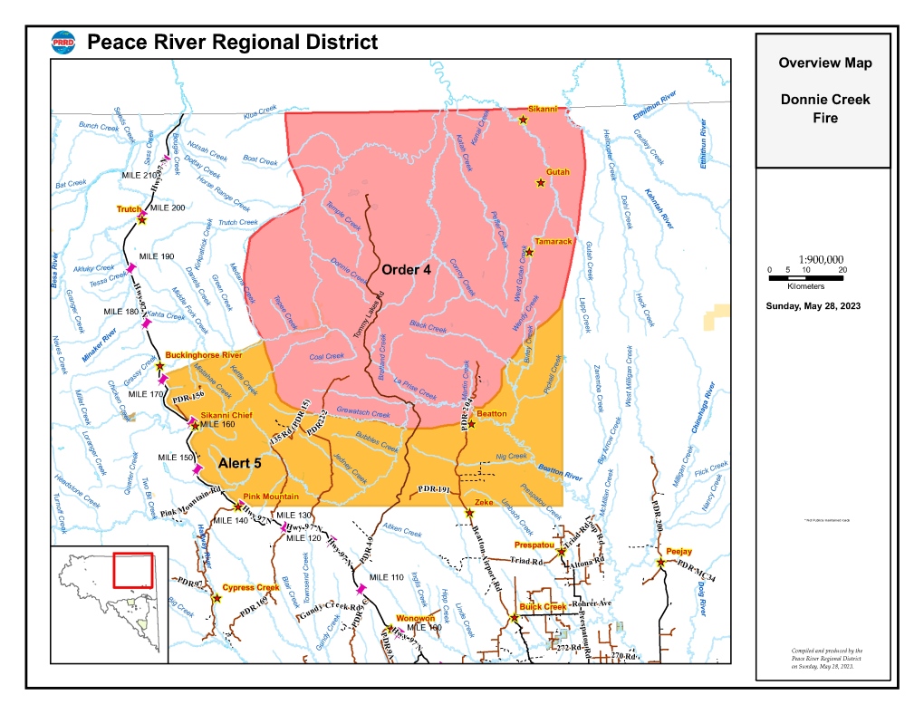
As a result, many are being told to leave their homes. A previous evacuation alert has been upgraded to an evacuation order, and the areas under evacuation alert have expanded.
The Peace River Regional District issued an evacuation order Sunday morning for the following areas:
• The area north of Grewatsch Creek on PDR 222.
• The area north of km 44 on Tommy Lakes Road.
• The area north of km 20 on PDR 204 (Beatton Airport Road).
• Extending north to the border with the Northern Rockies Regional Municipality.
Those within the evacuation area are asked to leave immediately and head toward Fort St. John.
The order does not apply to First Nations communities, as they issue their own orders and alerts, according to PRRD.
Others are being asked to prepare to leave on short notice. The evacuation alert applies to the following areas:
• One km east of Highway 97 between km 225 and km 273.
• Extending East 88 km from a point 1 km east of km 225 on Highway 97, and then extending 56 km North to the boundary of the evacuation order.
• Extending North-East from a point 1km east of km 273 on Highway 97 to the confluence of the Buckinghorse River and Medena Creek, then continuing east along the southern boundary of the evacuation order.
BC Wildfire Service says winds on Saturday pushed the fire toward stands of black spruce and higher temperatures combined with dry air contributed to “extremely vigorous” fire behaviour, including in areas near oil and gas industry camps and infrastructure.
Sunday morning brought cooler temperatures and some precipitation, but the service says “significant fire activity” is anticipated heading into this week.
It says a sunny and drying trend is continuing, with no further rain in the forecast.
The service says five 20-person crews and five helicopters are currently fighting the blaze first discovered on May 12, with lightning as the suspected cause.
 The Northern Rockies Regional Municipality has also issued an evacuation order due to the out of control Klua Lakes wildfire, which has grown to 26,871 hectares. The order applies to the following area:
• Bounded on the south by the NRRM/PRRD boundary
• From a point on the west side at longitude 122 16.03W arched up to a northern point at latitude 58 17.52’N
• From a point on the east side at longitude 121 00.45W arched up to a northern point at latitude 58 17.52’N
Both fires are believed to be caused by lightning, according to BC Wildfire Service.
With files from The Canadian Press.
CTVNews.ca Top Stories

N.Y. prosecutors charge Luigi Mangione with murder of UnitedHealthcare CEO, court records show
Late Monday, Manhattan prosecutors filed murder and other charges against Luigi Nicholas Mangione in the killing of UnitedHealthcare's CEO, according to an online court docket.
Union dropped wage demand to 19% over four years in Canada Post negotiations: CUPW
The Canadian Union of Postal Workers (CUPW) has reportedly dropped its wage demand to 19 per cent over four years, CUPW negotiator Jim Gallant told CTV News.
Taxpayer-funded Eras Tour tickets returned by federal minister
While tens of thousands of fans packed Vancouver's BC Place for the last shows of Taylor Swift's Eras Tour this weekend, a federal cabinet minister wasn't one of them.
Sudbury, Ont., family traumatized after hospital said loved one had been released, when in fact they had passed away
Sudbury resident Angela Vitiello says a staff member at Health Sciences North told her that her brother, Allan St. Martin, was released from the hospital late last month when, in fact, he had passed away.
What the upcoming holiday GST relief will mean for consumers
The federal government's GST break will arrive this Saturday, just in time for the last stretch of holiday shopping.
Liberal government survives third Conservative non-confidence vote
Conservative Leader Pierre Poilievre's latest attempt to topple the minority Liberal government in a non-confidence vote failed on Monday, thanks to the New Democrats.
Katie Holmes refutes story about daughter Suri Cruise’s fortune
Katie Holmes has posted a screen grab of a Daily Mail article, which reported that her 18-year old daughter, whose father is Tom Cruise, is now a "millionaire."
Polygamous U.S. sect leader gets 50 years in prison in scheme to orchestrate sex involving children
A polygamist religious leader in the U.S. who claimed more than 20 spiritual “wives” including 10 underage girls was sentenced to 50 years in prison on Monday.
Trudeau says dealing with Trump will be 'a little more challenging' than last time
Prime Minister Justin Trudeau said dealing with incoming president Donald Trump and his thundering on trade will be 'a little more challenging' than the last time.


