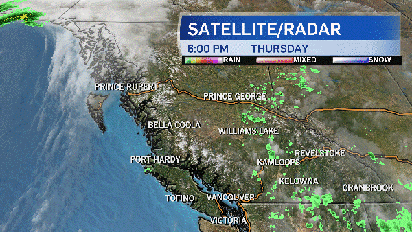
Metro Vancouver is preparing for an onslaught of heavy rain and winds as a trio of storms barrels toward B.C.'s South Coast, carrying with it the remnants of a Pacific typhoon.
Environment Canada has issued a rainfall warning for Metro Vancouver, forecasting the area will be pelted with rain overnight as the first of three powerful October storms makes landfall.
The weather agency's warning suggests that the storm will begin as a light rainfall on Wednesday evening, but will transition into a much stronger storm between 2 a.m. and 8 a.m. on Thursday, with rainfall rates up to 10 millimetres per hour.
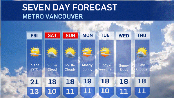
The rain will ease or stop on Thursday morning after as many as 60 millimetres have fallen on the area. After a few hours of relief, rain and strong winds are in the forecast for Thursday evening as the second of the sequential storms reaches the Lower Mainland.
Areas closest to the North Shore mountains are expected to be hit hardest during the downpour.
As a result of the concentration near the mountains, the popular trail known as the Grouse Grind will be closed as of Thursday morning. Metro Vancouver officials will decide when to reopen it based on how the storms pass through the area.
The City of North Vancouver has packed up hundreds of sandbags, ready to be used in case of flooding. Staff has also been clearing catch basins to make room for a sudden increase in precipitation.
"Heavy downpours can cause flash floods and water pooling on roads," the rainfall warning said.
During the rainfall and subsequent storms, TransLink will be taking part in Emergency Management BC and Environment Canada conference calls to be prepared as the forecast changes.
TransLink is also fueling its generators so they are ready to operate in case of outages. The transit provider warned that falling tree branches could be an issue for overhead trolley wires, and said it is checking areas that may be most at-risk of damage.
Transit supervisors and other support staff will be out on the road monitoring problem areas.
Meanwhile, emergency officials are advising the public of when it is appropriate to call 911.
Residents are asked only to dial the number if there is an immediate threat to public safety. If trees are down or the power goes out but no one is injured, residents are asked to contact city services instead.
In addition to the rainfall warning, Metro Vancouver also falls under a special weather statement first issued on Tuesday, but updated Wednesday afternoon.
The weather statement covers an area spanning from the west coast of Vancouver Island to the eastern portion of the Fraser Valley.
That statement predicts a similar rain pattern, with between 30 and 50 millimetres expected between Wednesday night and Thursday morning. It echoes the rainfall warning with a reminder that a break in rain on Thursday afternoon will be short-lived, as the second storm is expected to hit that night.
The weather statement says that the South Coast can expect the heaviest rain and winds on Saturday, as the third and potentially most powerful storm approaches.
The low-pressure system will be accompanied by strong winds, but it is too early to determine its exact track. Computer models are predicting the eye of the storm to land anywhere from southern Washington State to northern Vancouver Island, the statement said.
Saturday's storm will be fueled by what's left of Typhoon Songda, a powerful tropical cyclone that formed in the Pacific Ocean earlier this week.
"Remnants of Typhoon Songda could pack quite a punch," Environment Canada meteorologist Matt MacDonald told CTV Vancouver on Tuesday.
"Currently the forecast models are developing as to a major storm so we'll have to wait and see as we get closer, but definitely potential is there for widespread impacts and strong winds."
Total rainfall accumulation from all three storms may exceed 200 millimetres on Vancouver Island, and 100 millimetres in B.C.'s inner coastal regions. The highest amount of rainfall is expected in areas closest to the mountains.
Because the later storms are still days away, Environment Canada will issue more detailed statements and warnings when the storm track becomes clearer.
The following areas are currently under the agency's special weather statement:
- East Vancouver Island
- Fraser Valley
- Greater Victoria
- Howe Sound
- Inland Vancouver Island
- Metro Vancouver
- North Vancouver Island
- Southern Gulf Islands
- Sunshine Coast
- West Vancouver Island
- Whistler