

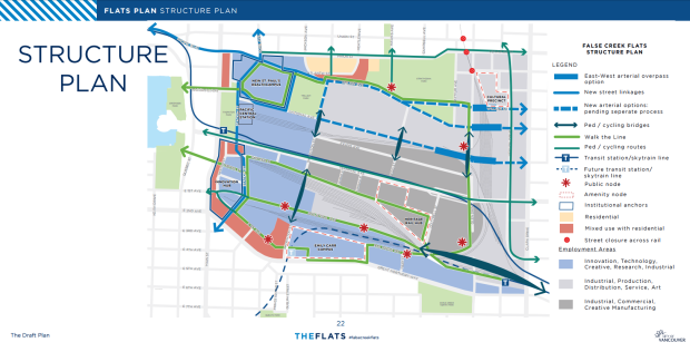
As the city moves closer to removing Vancouver's viaducts, the focus is turning to which side roads will become main arteries for traffic.
Getting in and out of the city is difficult to begin with, but without the Georgia and Dunsmuir viaducts, and with big changes coming to False Creek Flats, drivers are going to have to find another route.
The requirements: The feeder route must run east-west, and connect with the downtown core. It also needs to be able to support rush-hour traffic.
"There is no easy option," said City of Vancouver director of transportation Lon LaClaire. "All the options require trade-offs."
The city is working on a major project that will see the replacement of Prior and Venables as a main east-west route.
With the city looking at three different options for what will become a busy thoroughfare carrying thousands of vehicles a day, people who live and work near the three proposed routes are voicing concerns about what the changes will mean for the neighbourhood.
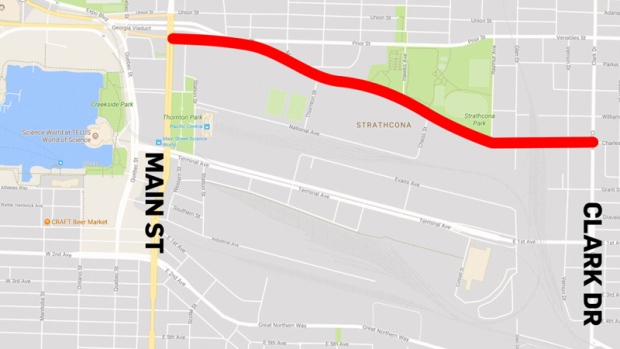
MALKIN AVENUE
One is Malkin Avenue, a road that hugs the south side of Strathcona Park, and is also known as "Produce Row." The avenue hosts several produce distribution warehouses, and those who work on the Row worry a traffic takeover would stall trucks trying to head in and out of the area for deliveries.
"If we put in another 15,000 or 20,000 cars a day down Malkin it would make most of our businesses impossible to run," said Discovery Organics manager Damien Bryan.
A city report estimates the project would cost between $80 million and $130 million, with the bulk of the budget going to land acquisition and overpass structure.
The route would also run alongside community gardens. David Tracey has gardened in the area for years.
“These kind of places you can’t put a dollar price on,” he explained. “These kind of places you can’t strike off on the map when they’re inconvenient according to how the economy and traffic has to go. I hope the city takes a look at it from the wider point of view, and takes an ecological look at the big picture of these things.”
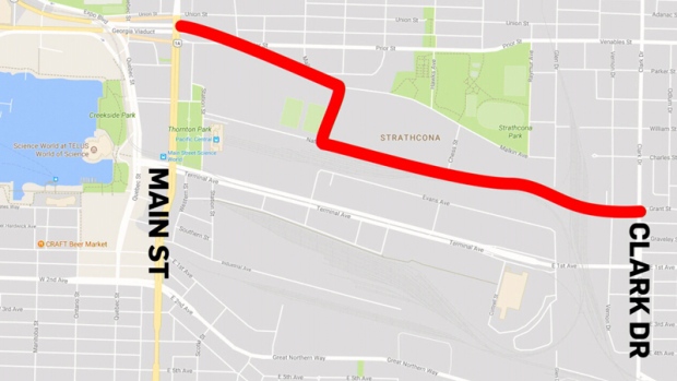
NATIONAL AVENUE
Another option just one block south of Malkin is National Avenue, but repurposing the roadway for high volumes of vehicle traffic would require a Vancouver fire training facility to move. The National Avenue option is the most expensive, with a price tag of up to $230 million. Overpass structure alone could cost up to $90 million, and acquiring the land is expected to cost between $75 million and $105 million.
National is also close to Terminal Avenue, which LaClaire said "doesn't create a very good arterial spacing."
WILLIAM STREET
The third option is William Street – an alternative that was initially ruled out but brought back into consideration. William runs from Strathcona Park to Boundary Road and into Burnaby, but in many places the road is split by crossroads, continuing on to the north or south in a step-like pattern rather than straight across the city.
The street would have to first be aligned. Officials would then have to route it either through the park or around it, making this a complex and controversial option.
"The big concern we have is it cuts through an existing park, and park space is irreplaceable once it's gone," said Dan Jackson of the Strathcona Residents' Association.
Strathcona Park falls under the jurisdiction of the Vancouver Park Board, so city staff have requested the board consider the option.
The city is asking for feedback on all three routes. There is no clear timeline on when a decision will be made.
An animated video from the city shows the False Creek Flats traffic plan west of Main Street.


