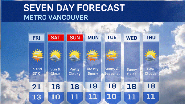
Just days after being blanketed in snow and slush, residents of B.C.'s Lower Mainland can expect another significant snowfall this weekend.
Environment Canada says there's a chance of snow starting Friday and carrying on through the weekend. Meteorologist Matt MacDonald said the snow is likely to last three or four days.
"It might be the most snow we've seen so far this season," he told CTV News on Tuesday.
MacDonald said the forecasted flurries can be blamed on the combination of a cold arctic air mass and moisture in the air heading inland off the Pacific Ocean.
More precise estimates are not yet available and the forecast could change before Friday, so MacDonald advises residents of the area to keep an eye on the forecast in the coming days.
"There's definitely a potential for more snowfall warnings this weekend," he said.
MacDonald said the Lower Mainland hasn't seen this much snow since the winter of 2007-2008.
"It's an exceptional start to winter here. We've seen several days with snow in the Valley and in Metro Vancouver and it's hung around. We've only seen a few spurts of rain here and there," he said.
The weather has been so unusual that the City of Vancouver has put construction projects on hold so hundreds of additional staff can be deployed to address wintry conditions. With some stores sold out of salt required to clear sidewalks, 10 of Vancouver's fire halls will be giving out bags to those who can't find it anywhere else.
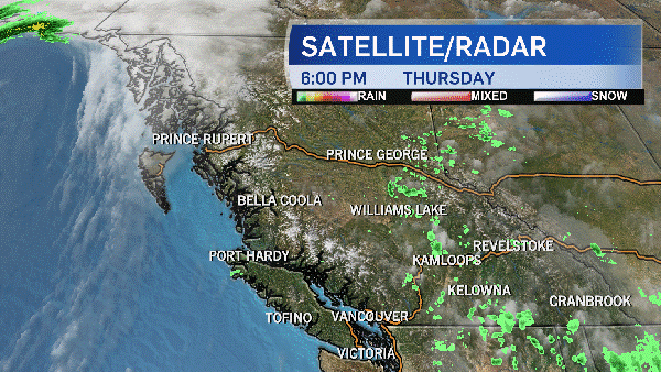
The arctic air mass expected to bring more snow to the area is also responsible for temperatures that are already between five and 10 degrees colder than the seasonal norm, MacDonald explained.
Adding in the wind chill, it feels as cold as -25 C in the Fraser Valley, Whistler and Howe Sound regions. Those parts of the province are currently under an arctic outflow warning from Environment Canada.
The weather agency warns the chilly temperatures are expected to last through Wednesday morning, with wind gusts of up to 90 km/h developing in the evening in Howe Sound, and 70 km/h until Wednesday in the Fraser Valley.
Wind gusts are much weaker in Metro Vancouver, bringing wind chills close to -10 C. The average high for Jan. 3 in Vancouver is 5.7 C, but Tuesday's high was around the freezing mark, and the low was -7. Abbotsford and Chilliwack have a similar seasonal norm, but the forecasted highs in those cities were -1 and -3 on Tuesday, and both face an overnight forecasted wind chill of -20.
Environment Canada warns that the unseasonable cold means there is an increased risk of frostbite or hypothermia. Anyone heading outdoors should dress warmly in layers covering as much skin as possible, and stay dry while outside.
"We're really trying to target homeless people who don't have proper shelter," MacDonald said.
"If they can seek shelter, try and stay warm. Get indoors."
The dangers of winter weather are well known to people like Marita Herrling, a 70-year-old woman who has been homeless in Chilliwack with her children for about five months.
"It was supposed to be just for a week or two. The place we were supposed to go…it didn't go through," she said.
One of Herrling's daughters was living in a tent next to her, but died a few weeks ago when the weight of the new-fallen snow caused her shelter to collapse.
"One of the tent posts caved in or whatever and smashed her across the face," Herrling said.
"It's a hard way to live," her surviving daughter said. She added that she worries for her mother's health, living in an environment that has already taken the life of one of her family members.
About 30 people live in the camp with Herrling's family, but it's estimated as many as 200 more are also sleeping outside at night.
In Abbotsford, vans go out at night, picking up homeless people and bringing them to nearby shelters.
"I've been in this role now for four years," said Bill Raddatz from Ruth and Naomi's Mission in Chilliwack.
"You've never ever heard of or seen what we are facing today."
With a report from CTV Vancouver's Michele Brunoro