

VANCOUVER -- The B.C. Centre for Disease Control has released another set of maps showing detailed regional data on COVID-19 infections in the province.
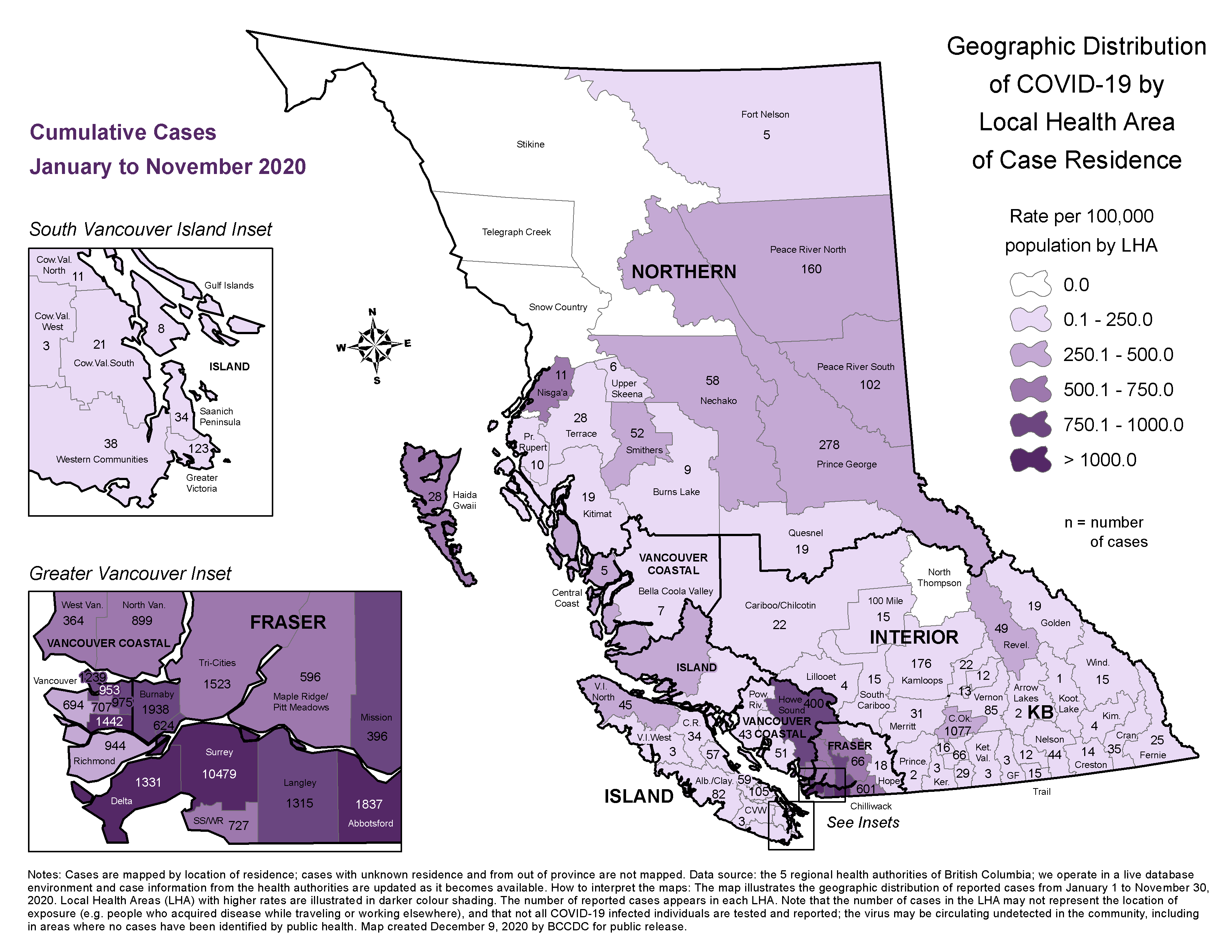
While previous maps showing coronavirus cases by local health area were released monthly and showed cumulative cases since the pandemic began, the BCCDC has begun releasing localized data on a weekly basis as well.
Provincial health officer Dr. Bonnie Henry said in her briefing Thursday that the weekly data releases were possible because of the surge in cases B.C. has experienced during the pandemic's second wave.
"As more cases accrue, we're able to give more information at a more local level," she said. "We're now at a point where you can't reidentify somebody by the geographic area that they live in because of the number of cases we've had."
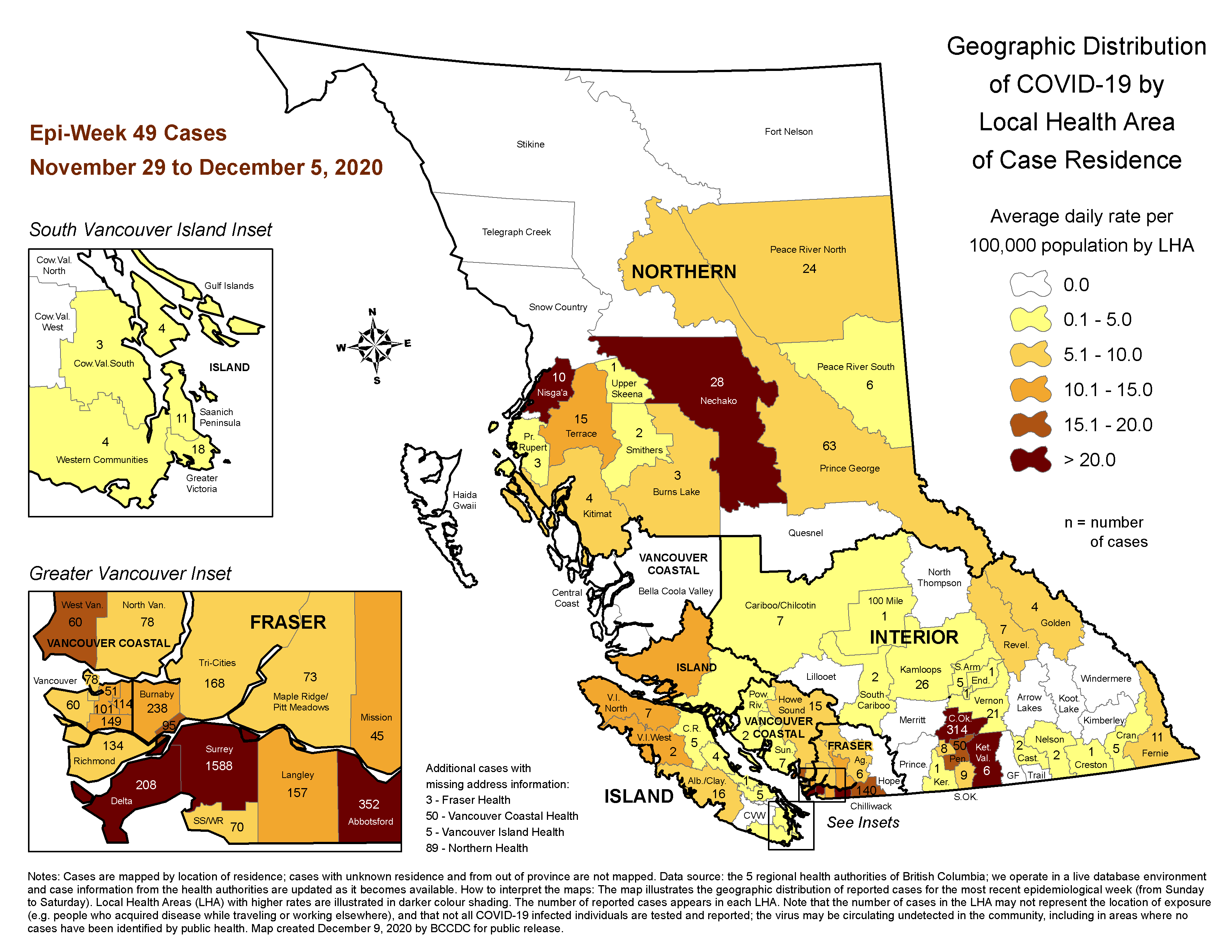
The first weekly update map shows COVID-19 infections recorded from Sunday, Nov. 29 to Saturday, Dec. 5, with regions shaded by the number of cases recorded per 100,000 residents, as well as numbers indicating the total number of cases in each region during the period. The full-sized map can be viewed on the BCCDC website.
As has long been the case in the cumulative count, the region with the most COVID-19 infections, overall, is the local health area that includes most of the City of Surrey.
The region recorded 1,588 cases during the week shown on the weekly map, and had recorded a cumulative total of 10,479 as of Nov. 30. The cumulative total represents roughly one-quarter of all COVID-19 infections recorded in B.C. since the pandemic began.
Notably, the South Surrey/White Rock local health area has recorded significantly fewer cases, both on a cumulative basis and in the last full week of data collection.
That area saw just 70 cases between Nov. 29 and Dec. 5, and had recorded a total of 727 as of Nov. 30.
The South Surrey/White Rock region fares better than the rest of the City of Surrey on a per-capita basis as well. Since the pandemic began, the region has recorded between 500 and 750 cases per 100,000 residents, compared to more than 1,000 infections per 100,000 in Surrey proper.
The per-capita gap has been significant over the last week as well, with South Surrey/White Rock recording between 5 and 10 cases per 100,000 residents each day, while the rest of Surrey has seen more than 20 per 100,000 per day.
Other regions in the Lower Mainland that have seen more than 20 daily infections per 100,000 residents, on average, over the last week of data include the cities of Delta and Abbotsford, where 208 and 352 total cases were recorded, respectively.
Notably, all of those local health areas are in the Fraser Health region. None of the local health areas that make up the Vancouver Coastal Health region saw as many cases per capita on a daily basis between Nov. 29 and Dec. 5.
The largest number of per capita cases in Vancouver Coastal Health during that period was recorded in West Vancouver, where 60 cases in total were recorded, equating to between 15 and 20 infections per 100,000 residents each day.
Elsewhere in the province, several regions recorded more than 20 cases per 100,000 residents over the last week of available data.
In the Interior Health region, the Central Okanagan and Kettle Valley local health areas each fall into the highest cases-per-capita category, though they recorded dramatically different overall totals.
In Central Okanagan, which includes the City of Kelowna, 314 infections were detected between Nov. 29 and Dec. 5. In Kettle Valley, which has a much smaller population, just six cases were recorded, overall, but that still translates into more than 20 per 100,000 residents.
Similarly, a pair of sparsely populated regions in Northern Health saw large numbers of per-capita cases in the last week. There were 28 total infections recorded in the Nechako region and 10 in the Nisga'a region, but each of those totals equates to more than 20 cases per 100,000 residents each day.
On Vancouver Island, there are no regions that have seen more than 15 daily cases per 100,000.
According to the map of cumulative cases, there were still four local health areas in the province that hadn't recorded a single case of the coronavirus as of Nov. 30. Three of those regions - Stikine, Telegraph Creek and Snow Country - are located in B.C.'s northwest. The other one is the North Thompson local health area in Interior Health.
Every other local health area in the province has seen at least one case of COVID-19 since January, and the BCCDC notes that the virus that causes the disease could still be circulating undetected even in places where no positive tests have been recorded.
Henry herself stressed this message on Thursday, saying the province has seen increased transmission in many communities across the north in recent weeks.
"This virus doesn't understand who we are or where we live or what community we belong to, and it is transmitting in all communities around B.C.," she said.


