Lower Mainland likely facing colder-than-average spring, Environment Canada forecasts
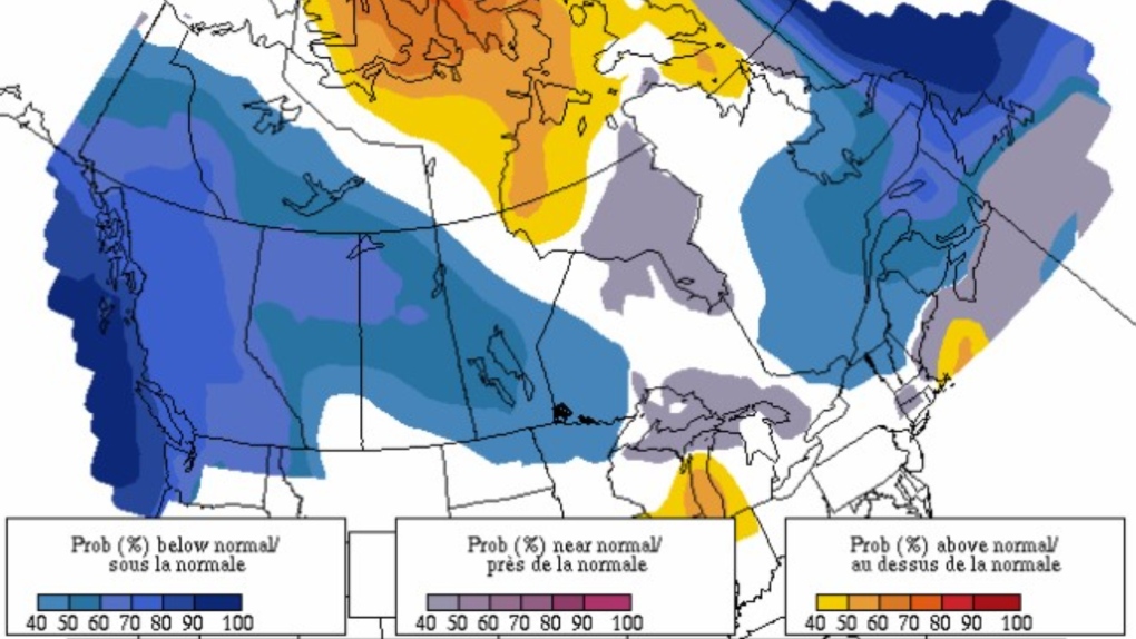
 An Environment Canada heat map showing the likelihood of temperatures being colder, average or warm from March through May 2022. (Environment and Climate Change Canada)
B.C.'s Lower Mainland could be in for a colder-and-average spring thanks to a lingering La Nina weather pattern, according to the latest seasonal outlook from Environment and Climate Change Canada.
The agency's spring forecast calls for some chillier temperatures from March through May, though meteorologist Doug Lundquist noted the weather tends to fluctuate "a bit like a rollercoaster" at this time of year.
"Weather has ups and downs, and there will be plenty of warmer periods in there as well," Lundquist told CTV News over the phone from Kelowna. "We're definitely on a warmer trend now."
La Nina events tend to bring icier winters in British Columbia, as the province experienced this year with several record-breaking cold snaps.
If the weather pattern persists over the coming weeks and months, Lundquist said it could work against the natural progression of rising spring temperatures, causing them to dip a few degrees colder than usual.
"Instead of having, for example, temperatures in the double-digits, we might see them progress into the high single-digits, with frosty nights again," he added.
Forecasters are predicting a colder spring with 70 to 80 per cent confidence, according to an Environment Canada heat map (LINK), but Lundquist said there's still a chance temperatures could be average – or even warmer-than-usual – in the Lower Mainland.
"Climate change is tending to make a warmer world," he said, noting there are a number of wild card factors that cause variability in the weather.
As far as precipitation goes, Lundquist said there aren't clear indicators pointing to a wetter or drier spring, calling it "pretty close to impossible" to make rainfall predictions this year.
He stressed that daily forecasts are the most important ones to monitor, as many British Columbians learned during the extreme weather events last year last year.
"The day-by-day weather matters more for our safety than seasonal weather," Lundquist said, adding that the River Forecast Centre and B.C. Wildfire Service also provide valuable forecasts.
"Always stay plugged in."
CTVNews.ca Top Stories

Can the Governor General do what Pierre Poilievre is asking? This expert says no
A historically difficult week for Prime Minister Justin Trudeau and his Liberal government ended with a renewed push from Conservative Leader Pierre Poilievre to topple this government – this time in the form a letter to the Governor General.
'I'm still thinking pinch me': lost puppy reunited with family after five years
After almost five years of searching and never giving up hope, the Tuffin family received the best Christmas gift they could have hoped for: being reunited with their long-lost puppy.
Two U.S. Navy pilots shot down over Red Sea in apparent 'friendly fire' incident, U.S. military says
Two U.S. Navy pilots were shot down Sunday over the Red Sea in an apparent 'friendly fire' incident, the U.S military said, marking the most serious incident to threaten troops in over a year of America targeting Yemen's Houthi rebels.
Big splash: Halifax mermaid waves goodbye after 16 years
Halifax's Raina the Mermaid is closing her business after 16 years in the Maritimes.
OPP find wanted man by chance in eastern Ontario home, seize $50K worth of drugs
A wanted eastern Ontario man was found with $50,000 worth of drugs and cash on him in a home in Bancroft, Ont. on Friday morning, according to the Ontario Provincial Police (OPP).
Bluesky finds with growth comes growing pains - and bots
Bluesky has seen its user base soar since the U.S. presidential election, boosted by people seeking refuge from Elon Musk's X, which they view as increasingly leaning too far to the right given its owner's support of U.S. president-elect Donald Trump, or wanting an alternative to Meta's Threads and its algorithms.
B.C. mayor gets calls from across Canada about 'crazy' plan to recruit doctors
A British Columbia community's "out-of-the-box" plan to ease its family doctor shortage by hiring physicians as city employees is sparking interest from across Canada, says Colwood Mayor Doug Kobayashi.
It was Grandma, in the cafe with a Scrabble tile: Game cafes are big holiday business
It’s the holidays, which means for many across the Prairies, there’s no better time to get locked in a dungeon with a dragon.
Cancer centre raises $2.7 million for purchase of 'game changer' surgical robot
The Windsor Cancer Centre Foundation has raised a record breaking $2.7 million through the Grow on Windsor Campaign.


