A storm so powerful it knocked a massive tree onto an SUV overnight is only a taste of what's to come as the second of three approaches B.C.'s South Coast.
The first of a trio of wicked storms moving in off the Pacific Ocean led to a close call for a North Vancouver family when the massive tree fell onto their vehicle and crushed it, just steps from where residents were sleeping early Thursday morning.
The storm was strong enough to bring down the tree on Silverdale Place, the impact of which sheered the roof off the SUV and left the trunk lying in the back seats. Large branches also hit part of the home.
One of the residents of the home, a teen named Hayden, said the enormous tree narrowly missed hitting their bedrooms, leaving him "pretty shaken."
"It [just] missed my mom's room and my room… and it sounded like thunder but it kept coming and it was pretty scary," he told CTV Morning Live.
Firefighters were called around 1:30 a.m. to help clean up the mess and make sure the area was safe.
The scene on Silverdale Place was all too familiar for the Boora family in Surrey, who had a tree split the top floor of their home in half during a storm in October 2014.
"It was the loudest thing I'd ever heard. It was like a semi had just ran into the house," Bill Boora recalled.
Boora had just left the room, and would have been crushed by the tree had it fallen a few minutes earlier. His wife and son were asleep in a bed next to where it fell, but were unharmed in the storm.
The family has cut down all trees that could be a danger in a storm, but some of the trees bordering their property are on park land and can't be removed. With the next in the series of storms fast approaching, the family plans to spend the night in their basement to be safe.
"We learned a lot from the last one that it's not a risk we want to take," Boora said. "The house can be repaired. Family can't."
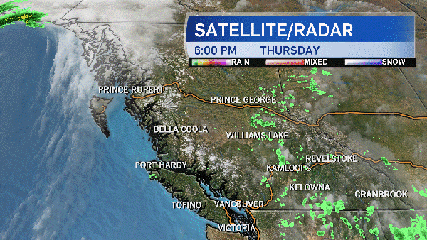
Metro Vancouver and Vancouver Island were pelted with rain and lashed by strong winds, but the storm that blew through overnight was much less powerful than the one forecast to make landfall on Saturday. And in between, another storm will punish the area.
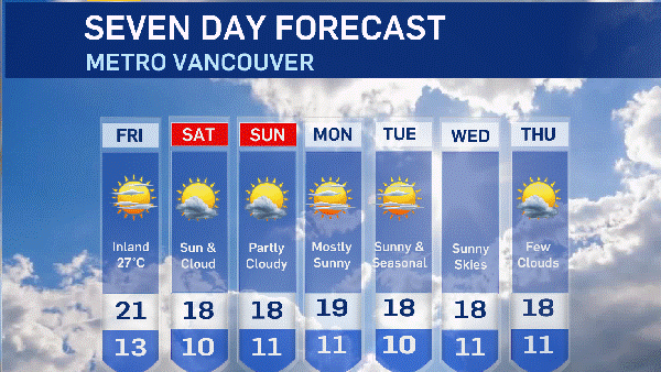
The second of the three is expected to hit Thursday night, with rain expected to begin early in the evening. Environment Canada forecasts that the winds that carry the rain toward land will pick up during the night, and may reach speeds of 70 km/h by Friday morning.
The wind is expected to be strongest in Port Alberni, where gusts may even reach 90 km/h at the height of the storm.
A wind warning has been issued for parts of Vancouver Island, the Gulf islands, Sunshine Coast, Howe Sound and Metro Vancouver shortly before noon.
With Metro Vancouver's North Shore often hit first and the hardest during rainstorms, the popular Grouse Grind hiking trail was shut down as a precaution. The trail will be reopened when officials decide it is safe to do so.
Environment Canada is warning that the strong winds may topple more trees and take down power lines. Outages "should be expected," the weather agency warned.
"Loose objects may be tossed by the wind and cause injury or damage. High winds may toss loose objects or cause tree branches to break," it's wind warning said.
In the Vancouver area, municipal crews have brought in additional employees and have several standing by in case of emergencies. BC Hydro is reminding residents of the affected areas that they should prepare for possible outages ahead of time, ideally before the wind gusts begin.
Downpours are also in the forecast for Thursday as the second of the sequential storms reaches the Lower Mainland in the evening. While heavy rain is expected in all areas in the storm's path, a rainfall warning is only in effect for Howe Sound.
The federal weather agency warns that heavy downpours in the area could cause flash flooding and water pooling on roads, and that the Sound will be hit with between 50 and 80 millimetres of rain more than the rest of the coast.
Environment Canada has also issued a special weather statement issued for much of B.C.'s South Coast warns that the worst part of the storm is expected overnight and Friday morning.
The third and potentially devastating storm is expected to approach the coast Saturday, although the exact track of the storm is still uncertain, says the weather agency. Computer weather models predict it will make landfall anywhere from Washington State to central Vancouver Island.
The low-pressure system carrying the storms to the South Coast is being fuelled by the remnants of Typhoon Songda, a powerful tropical cyclone that formed in the Pacific Ocean earlier this week.
Initial estimates suggested that the total rainfall accumulation from all three storms may exceed 200 millimetres on Vancouver Island, and 100 millimetres in B.C.'s inner coastal regions. The highest amount of rainfall is expected in areas closest to the mountains.
Special weather statements have been issued for the following regions:
- East Vancouver Island
- Fraser Valley
- Greater Victoria
- Howe Sound
- Inland Vancouver Island
- Metro Vancouver
- North Vancouver Island
- Southern Gulf Islands
- Sunshine Coast
- West Vancouver Island
- Whistler