Snowfall records could be broken in Metro Vancouver this weekend: Environment Canada
Snowfall warnings have been issued for Metro Vancouver and the Fraser Valley, with a heavy dump of snow in the forecast this weekend.
Environment Canada says this blast of winter could break records and is urging people to stay off the roads if possible.
CITIES PREPARING
City crews across the Lower Mainland have really had the upper hand this time around.
They’ve known a storm was coming for days now and, while the weather has been extremely cold, it’s also been dry for the most part.
That’s allowed crews to prepare most streets in advance with salt and brine.
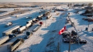
On Friday morning, it was all hands on deck at the Surrey Works Yard and Operations Centre.
There was a steady stream of brining trucks filling up and hitting the road.
The city says it’s well prepared with more than 10,000 tonnes of salt on hand.
When the snow starts to stick Saturday, crews will hit the major routes first.
Since they’ll be able to cover more ground in light traffic, crews are asking people to stay home.
“Of course, during an actual event if the traffic's bad, that can really hinder our response time,” said Matt Brown, the City of Surrey’s street manager.
He says the city faces some unique challenges as well, such as a wide variety of elevation levels.
It was a similar story in Vancouver, where Mayor Ken Sim took to Twitter to say crews have been "fully deployed" to start pre-treating roads ahead of the storm.
WARNINGS ABOUND
Nearly the entire province was under some sort of weather alert Friday, as B.C. was hit with a deep freeze.
Environment Canada says light flakes will start to fall in Metro Vancouver on Saturday afternoon, which will intensify to heavy snow by the evening.
The amount of snow will largely be determined by the strength of the arctic outflow winds.
Total accumulations of 15 to 25 centimetres are possible, while higher elevations may see up to 35.
It’s expected to ease in most areas by Sunday afternoon, with sunny skies in the forecast.
RECORD-SETTING SNOW POSSIBLE
Environment Canada data for the City of Vancouver shows the most snowfall recorded on Feb. 25 since 1938 was 3.6 centimetres in 1955. For Feb. 26, the record was 13.2 centimetres in 1971.
Armel Castellan, an Emergency Preparedness Meteorologist with Environment Canada, says a sudden dump of snow like this is a little out of the ordinary for this time of year.
“This Arctic outflow kind of making its way to the south coast has brought us temperatures that are well below seasonal values—you know, almost 10 degrees below,” he said.
It’s expected to warm up fairly quickly, however. Castellan said the region is likely to see temperatures rise to sit in the mid single digits as the storm passes, making the conditions perfect for snowman building.
Temperatures should be even higher by the middle of next week.


CTVNews.ca Top Stories

B.C. woman facing steep medical bills, uncertain future after Thailand crash
The family of a Victoria, B.C., woman who was seriously injured in an accident in Thailand is pleading for help as medical bills pile up.
LIVE @ 4 EDT
LIVE @ 4 EDT Freeland to present 2024 federal budget, promising billions in new spending
Canadians will learn Tuesday the entirety of the federal Liberal government's new spending plans, and how they intend to pay for them, when Deputy Prime Minister and Finance Minister Chrystia Freeland tables the 2024 federal budget.
Annual inflation rate increased to 2.9% in March
The annual inflation rate ticked higher in March compared with February, boosted by higher prices for gasoline, Statistics Canada said Tuesday.
Inmate who escaped from N.B. prison has long history of violent crimes
An inmate who escaped from Dorchester Penitentiary in Dorchester, N.B., on Saturday evening has a long history of violent crimes and a history of escaping custody.
Tim Hortons launches pizza nationally to 'stretch the brand' to afternoon, night
Tim Hortons is launching flatbread pizzas nationally in a bid to pick up more afternoon and evening customers.
Thousands of dollars worth of tropical fish stolen from Ottawa Valley restaurant
Ontario Provincial Police are investigating the theft of "several thousand" dollars worth of tropical fish stolen from an Upper Ottawa Valley restaurant last week.
Ontario woman charged almost $7,000 for 20-minute taxi ride abroad
An Ontario woman was shocked to find she’d been charged nearly $7,000 after unknowingly using an unauthorized taxi company while on vacation in January.
NASA confirms mystery object that crashed through roof of Florida home came from space station
NASA confirmed Monday that a mystery object that crashed through the roof of a Florida home last month was a chunk of space junk from equipment discarded at the International Space Station.
Budget 2024 'likely to be the worst' in decades, former BoC governor says
Without having seen it, former Bank of Canada governor David Dodge believes that Tuesday's 2024 federal budget from Deputy Prime Minister and Finance Minister Chrystia Freeland is 'likely to be the worst budget' in decades.
Shopping Trends
The Shopping Trends team is independent of the journalists at CTV News. We may earn a commission when you use our links to shop. Read about us.


Vancouver Island
-
B.C. woman facing steep medical bills, uncertain future after Thailand crash
The family of a Victoria, B.C., woman who was seriously injured in an accident in Thailand is pleading for help as medical bills pile up.
-
Planning next bid to rescue B.C. orca calf will take 'few days': Fisheries Department
The Department of Fisheries says planning for a new attempt to rescue an orca calf trapped in a Vancouver Island lagoon will be finalized in the next few days but no date has been set.
-
B.C. fraudster who lured investors with promise to help homeless fined by securities regulator
A Vancouver woman whose company duped investors by promising big returns on real-estate deals that would house the homeless has been ordered to pay nearly $626,000 after the British Columbia Securities Commission deemed the operation a Ponzi scheme.
Kelowna
-

B.C. to add 240 complex-care housing units throughout province
British Columbia is planning to add 240 new units to its complex-care housing program, providing homes for people with mental-health and addictions challenges that overlap with other serious conditions.
-
Evacuation of Kelowna, B.C., apartment near construction site extended for two weeks
More than 80 residents from a low-income apartment building in Kelowna, B.C., have learned they won't be able to return to their homes for at least another two weeks.
-
2 men injured after 'road rage' incident with Dodge Ram driver, Kelowna RCMP say
Mounties are investigating a reported "road rage" incident in Kelowna, B.C., that left two men injured last week.
Edmonton
-

Tickets issued after large, unleashed dog spotted in front of home where boy was killed by dogs
Two tickets were issued after an unleashed dog was seen in front of a home where a boy died in a dog attack earlier this month.
-
Tamarack Valley shuts Alberta output after gas plant fire
Canada's Tamarack Valley Energy TVE.TO has temporarily shut production of about 6,200 barrels of oil equivalent per day (boepd) following a fire at a Canadian Natural Resources Ltd CNQ.TO gas plant in Alberta, the companies said on Monday.
-
Kevin Hart to headline Edmonton's Great Outdoors Comedy Festival
Comedian Kevin Hart will headline the Great Outdoors Comedy Festival (GOCF) in Edmonton this summer, organizers announced Tuesday.
Calgary
-
Jurors to hear closing arguments in trial for three men charged after Coutts blockade
Closing arguments are scheduled today for three men accused of orchestrating the border shutdown at Coutts, Alta., in early 2022.
-
Okotoks chosen to receive new EV charging stations
A community just south of Calgary is among eight Canadian municipalities that will have new charging stations installed as part of an Earth Day Canada campaign.
-
Innisfail man arrested after fleeing RCMP on stolen motorbike
Innisfail RCMP says charges have been laid against a 35-year-old man after he was found in possession of drugs and a stolen motorbike.
Lethbridge
-

Phillips calls for funding to be reinstated to Lethbridge Elder Abuse Response Network
Lethbridge West MLA Shannon Phillips is calling on the province to reinstate funding for the Lethbridge Elder Abuse Response Network.
-
Southern Alberta could be alive with the sound of rattlesnakes this weekend: expert
If you’re planning to head to the coulees this weekend to enjoy the nice weather, don’t forget to look down.
-
Lethbridge police team up with campaign to urge drivers to slow down
With the weather starting to feel like spring is really here, more kids will likely be outside enjoying the sunshine and warm temperatures, which organizers of the Slow Your Roll campaign say is a perfect time to re-launch the campaign.
Winnipeg
-
Rural Manitoba council may be dissolved after mass exodus of elected officials: province
A mass exodus of elected officials from a rural Manitoba municipality has put the community in limbo and may force the province to dissolve what's left of the crumbling council.
-
Here's how much rain fell in Manitoba on Monday
Spring has sprung in Manitoba, which means the return of April showers.
-
Blue Rodeo, Arkells to headline this summer’s Burt Block Parties
The lineup has been released for this year’s Burt Block Parties, inviting thousands of Winnipeggers to line the streets for the Exchange District outdoor concert series once again this summer.
Regina
-
'Puppet show': Saskatchewan finance minister apologizes for text to Speaker
Saskatchewan's finance minister was ordered to apologize after she sent the Speaker a text accusing him of letting the legislature devolve into an 'Opposition puppet show' on Monday.
-
Fresh off move to new facility Regina Humane Society puts on record setting telethon
It was a record breaking evening for the Regina Humane Society this past weekend.
-
Annual inflation rate increased to 2.9% in March
The annual inflation rate ticked higher in March compared with February, boosted by higher prices for gasoline, Statistics Canada said Tuesday.
Saskatoon
-

Sask. struggling to recruit and retain specialists, doctor says
Dr. Ana-Maria Bosonea is the only allergist in Saskatoon seeing children under 12, and now she’s moving to Alberta.
-
'Puppet show': Saskatchewan finance minister apologizes for text to Speaker
Saskatchewan's finance minister was ordered to apologize after she sent the Speaker a text accusing him of letting the legislature devolve into an 'Opposition puppet show' on Monday.
-
Saskatoon residents can expect some odour from city landfill as gas well project expands
The city says there may be some odour emanating from the landfill in the coming weeks as crews dig new gas wells and piping to collect more methane from decomposing waste.
Toronto
-

An Ontario family waited 3 years for trial in alleged murder of brother. Now they have to wait another year
An Ontario family that has waited three years for a trial in the alleged murder of a loved one has just been told they’ll have to wait another year.
-
Woman touched after Blue Jays star offers to sign jersey for ailing husband
Ontario resident Carla Norris-Hutcheson says she never expected to be gifted a Blue Jays jersey for her ailing husband when she sat alone at the team’s home opener next to a couple of kind strangers.
-
'Deplorable' conditions see sentences lowered at Toronto South Detention Centre: court
A growing number of judges presiding over Ontario's criminal cases are condemning 'deplorable' jail conditions at the Toronto South Detention Centre, where sentences continue to be shortened over inhumane conditions.
Montreal
-

Recycling Montreal's Olympic Stadium roof: international competition collects bids
An international competition is hoping to gather new and interesting ways to recycle Montreal's Olympic Stadium roof, which is set to be dismantled this summer.
-
Montreal Canadiens recall Logan Mailloux from AHL
The Montreal Canadiens have recalled defenceman Logan Mailloux from the AHL's Laval Rocket.
-
3 people arrested in Quebec City for assault, threats, forcible confinement
Quebec City police say three people were arrested in connection with an alleged assault in the Beauport borough.
Ottawa
-
 LIVE @ 4 EDT
LIVE @ 4 EDT Freeland to present 2024 federal budget, promising billions in new spending
Canadians will learn Tuesday the entirety of the federal Liberal government's new spending plans, and how they intend to pay for them, when Deputy Prime Minister and Finance Minister Chrystia Freeland tables the 2024 federal budget.
-
Thousands of dollars worth of tropical fish stolen from Ottawa Valley restaurant
Ontario Provincial Police are investigating the theft of "several thousand" dollars worth of tropical fish stolen from an Upper Ottawa Valley restaurant last week.
-
OPP investigating after human remains found in Ottawa River in Clarence-Rockland
Ontario Provincial Police are investigating after human remains were found in the Ottawa River in Clarence-Rockland on Monday.
Atlantic
-
Inmate who escaped from N.B. prison has long history of violent crimes
An inmate who escaped from Dorchester Penitentiary in Dorchester, N.B., on Saturday evening has a long history of violent crimes and a history of escaping custody.
-
Battery fires a concern for Maritime departments as numbers grow
Batteries power many things in our lives, from phones to laptops to even cars, but there’s a danger lurking in our battery dependency.
-
N.S. RCMP arrest man with 40 grams of cocaine, $2,000
Nova Scotia RCMP has arrested a 26-year-old man who allegedly tried to flee from officers in a vehicle and on foot Sunday night.
London
-

Students displaced following house fire
A number of students have been displaced after a house fire in east London near Fanshawe College. Crews were called to the scene on Prosperity Court late Monday night.
-
Fire hydrant struck in Sarnia, traffic reduced to one lane
All lanes of traffic have reopened after a vehicle struck a fire hydrant in Sarnia on Monday. It happened in the area of Michigan Avenue and Blackwell Road and caused officials to reduce eastbound traffic to one lane.
-
Traffic coming to a crawl on Main Street Exeter
Construction will slow down traffic moving through Exeter for the rest of the year. A reconstruction of the community's main street at the north end of town is underway.
Kitchener
-

Driveway paving scammers reported in Waterloo Region
Cambridge resident Samantha Falkiner explains why something felt "off" about the men who approached her and her neighbours on Friday.
-
Policing costs for St. Patrick’s Day celebrations in Waterloo increased by $51,000
Waterloo Regional Police Services has released the estimated total cost for the St. Patrick’s Day weekend in the city of Waterloo.
-
Report of person with weapon prompts hold and secure in Delhi
A Delhi, Ont. street was placed in hold and secure Tuesday morning after police got reports of someone with a weapon.
Northern Ontario
-

Northern Ont. driver missing after vehicle pulled into creek
Rescue crews are searching for a man reported missing on the weekend after the vehicle he was driving was pulled into a creek near the Quebec border in northern Ontario.
-
Ontario woman charged almost $7,000 for 20-minute taxi ride abroad
An Ontario woman was shocked to find she’d been charged nearly $7,000 after unknowingly using an unauthorized taxi company while on vacation in January.
-
Northern Ont. man acquitted of murder on James Bay coast
A northern Ontario family is devastated after a jury found a Moose Factory man not guilty of a 2021 murder.
N.L.
-

Protest averted as Newfoundland and Labrador premier helps reach pricing deal on crab
A pricing agreement has been reached between crab fishers and seafood processors that will allow for Newfoundland and Labrador's annual crab fishery to get started.
-
A fish harvester's protest threatens Newfoundland and Labrador's crab season -- again
Longliners across Newfoundland and Labrador are tied up once again, as a new protest by the province's fish harvesters threatens to derail the crab fishery for a second straight year.
-
Unique photo exhibit put cameras in the hands of survivors of domestic and sexual violence
A unique photo exhibit is putting cameras into the hands of survivors of domestic and sexual violence in Newfoundland and Labrador.


