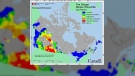
Rainfall warnings for Metro Vancouver and Fraser Valley
Vancouver -
Environment Canada has issued a number of rainfall warnings for the Lower Mainland this weekend.
Seventy-five to 150 mm of rain is expected, depending on what part of the region you’re in.
Howe Sound and the North Shore will be hit the hardest, the warning says.
The downpour is expected to continue into Saturday night with a short break Friday evening.
“Two successive frontal systems will cross the south coast between today and late Saturday night, with high water content associated with an atmospheric river flowing off the Pacific Ocean,” Environment Canada's statement says.
Armel Castellan, a warning preparedness meteorologist for Environment Canada says an atmospheric river is not like a typical storm, because it feeds moisture up from the subtropics.
“You're basically being sandwiched all of that moisture between a big high pressure off of California, and a huge low pressure in the Gulf of Alaska. And in between the two, you've got this filament of moisture coming up from the southwest towards our coast, and it's really like a fire hose,” Castellan explained.
High winds are also a possibility in some areas.
“The main event is actually overnight into Saturday where the highest intensities of the rain are going to come,”said Castellan.
Temperatures are expected to climb over the weekend which would lift freezing levels on local mountains near 2,500 metres.
Melting snow would create runoff, which could cause flooding in some areas due to higher water levels in streams.
Heavy downpours can cause flash floods and water pooling on roads.
“If visibility is reduced while driving, turn on your lights and maintain a safe following distance,” wrote Environment Canada.
Drivers are being urged to leave extra time on their commutes over the weekend in anticipation of what could be dangerous road conditions.
“It's definitely a reminder for everybody to be extra vigilant out there and make sure that you're taking the precautions. Even securing your own home by making sure that you've got your eaves cleared so that you're not dealing with a backlog of water in your gutter system,” said Castellan.
FALLOUT FROM HOT, DRY SUMMER
B.C.’s record-setting summer of hot and dry conditions is expected to play a role in this fall’s storm season.
“A long drought has a hydrophobic tendency for the soil, meaning it no longer can absorb moisture the same way than it does in the wet season,” explained Castellan.
The devastating wildfire season is also expected to have a major impact.
“Then you add on top of it wildfires scarring, in the burn scars, and then you can have essentially a lot of runoff very quickly. So those are things that are of concern. Potential for landslides goes up,” said Castellan.
POSSIBILITY OF INCREASED POWER OUTAGES
BC Hydro says it’s monitoring this weekend’s storm closely and will have increased staffing.
“We're anticipating a lot of rain to fall, and our crews are ready to head out and address any outages that come up at a moment's notice as quickly and as safely as possible,” said Kyle Donaldson, a spokesperson for BC Hydro.
He says last summer’s drought could also cause more outages this fall.
“The vegetation is extremely dry, if not dead in some areas. All of this rain is going to really saturate the ground and could present a problem. With just a little bit of wind, some of these damaged or dead trees could be knocked over a lot easier than in years past,” Donaldson explained.
He says crews will respond to outages as quickly as possible, but is encouraging all British Columbians to have a first aid kit, food and water, extra batteries on hand just in case.
“If you come across a downed power line over the next couple of days, the best thing to do is stay away. Stay at least 10 meters away. Call 911 immediately and you should consider it live,” he warned.
LONG-TERM FORECAST
Looking ahead to the long term forecast, Castellan believes a La Niña is likely coming this winter.
A La Niña is an oceanic and atmospheric event that involves the cooling of surface ocean waters, which may result in colder temperatures and snow.
“It will likely be weak, not too strong. Therefore the impact might not be extreme, but it sure does kind of load the dice if you will, to potential for snow events right down to sea level in places like Vancouver, Victoria and Nanaimo,” Castellan told CTV News.


CTVNews.ca Top Stories

BREAKING NEWS
BREAKING NEWS Honda to get up to $5B in govt help for EV battery, assembly plants
Honda is set to build an electric vehicle battery plant next to its Alliston, Ont., assembly plant, which it is retooling to produce fully electric vehicles, all part of a $15-billion project that is expected to include up to $5 billion in public money.
BREAKING
BREAKING New York appeals court overturns Harvey Weinstein's 2020 rape conviction from landmark #MeToo trial
New York’s highest court on Thursday overturned Harvey Weinstein’s 2020 rape conviction, finding the judge at the landmark #MeToo trial prejudiced the ex-movie mogul with improper rulings, including a decision to let women testify about allegations that weren’t part of the case.
Residents of northern Alberta First Nation told to shelter in place
Residents of John D'Or Prairie, a community on the Little Red River Cree Nation in northern Alberta, were told to take shelter Thursday morning during a police operation.
Monthly earnings rise, payroll employment falls: jobs report
The number of vacant jobs in Canada increased in February, while monthly payroll employment decreased in food services, manufacturing, and retail trade, among other sectors.
Doctors say capital gains tax changes will jeopardize their retirement. Is that true?
The Canadian Medical Association asserts the Liberals' proposed changes to capital gains taxation will put doctors' retirement savings in jeopardy, but some financial experts insist incorporated professionals are not as doomed as they say they are.
Secret $70M Lotto Max winners break their silence
During a special winner celebration near their hometown, Doug and Enid shared the story of how they discovered they were holding a Lotto Max ticket worth $70 million and how they kept this huge secret for so long.
Remains from a mother-daughter cold case were found nearly 24 years later, after a deathbed confession from the suspect
A West Virginia father is getting some sense of closure after authorities found the remains of his young daughter and her mother following a deathbed confession from the man believed to have fatally shot them nearly two decades ago.
Something in the water? Canadian family latest to spot elusive 'Loch Ness Monster'
For centuries, people have wondered what, if anything, might be lurking beneath the surface of Loch Ness in Scotland. When Canadian couple Parry Malm and Shannon Wiseman visited the Scottish highlands earlier this month with their two children, they didn’t expect to become part of the mystery.
Metro Vancouver mayors call for serial killer Robert Pickton to be denied parole
A dozen mayors from around Metro Vancouver say federal Attorney General and Justice Minister Arif Virani should deny parole for notorious B.C. serial killer Robert Pickton, and reassess the parole and sentencing system for 'prolific offenders and mass murderers.'
Shopping Trends
The Shopping Trends team is independent of the journalists at CTV News. We may earn a commission when you use our links to shop. Read about us.


Vancouver Island
-

'It was instant karma': Viral video captures failed theft attempt in Nanaimo, B.C.
Mounties in Nanaimo, B.C., say two late-night revellers are lucky their allegedly drunken antics weren't reported to police after security cameras captured the men trying to steal a heavy sign from a downtown business.
-
B.C. mom distributes air quality monitors after 9-year-old's asthma death during wildfires
Nine-year-old Carter Vigh was having a great day last July 11, visiting a waterpark, enjoying a picnic lunch and playing soccer with other kids at a day camp run by his mother, Amber Vigh.
-
'Enjoy the run' but don’t expect major economic boost from Canucks playoffs: expert
A Canadian sports economist is encouraging Canucks fans to enjoy the team’s playoff run, but cautioning against having big expectations around economic spinoffs.
Kelowna
-

B.C. man rescues starving dachshund trapped in carrier: BC SPCA
An emaciated dachshund is now recovering thanks to a Good Samaritan who found the pup near a biking trail in Kelowna, according to the BC SPCA.
-
Search crews called in after missing Kelowna senior's truck found
Search and rescue crews have been called in after a vehicle belonging to a missing senior was located near a rural intersection outside of Kelowna Tuesday.
-
Homicide investigation underway after body found near Kelowna, B.C.
Major crime detectives in British Columbia are investigating a suspected homicide after a body was found in a remote area southeast Kelowna over the weekend.
Edmonton
-

Nurse practitioners to make 80% as much as family doctors for publicly-funded primary care
The Alberta government says it will pay nurse practitioners 80 per cent of what family doctors are paid – if they want to practice comprehensive primary care.
-
Residents of northern Alberta First Nation told to shelter in place
Residents of John D'Or Prairie, a community on the Little Red River Cree Nation in northern Alberta, were told to take shelter Thursday morning during a police operation.
-
Measles case in Edmonton prompts exposure warning
Alberta Health Services issued a measles alert in Edmonton Wednesday after confirming a case.
Calgary
-

Coyote calls on the rise in Calgary; city wildlife team advises caution
The City of Calgary's wildlife team says they're fielding hundreds of calls about coyotes.
-
Ex-Calgary mayor Nenshi expected to be focus of first Alberta NDP leadership debate
Former Calgary mayor Naheed Nenshi is expected to be the centre of attention as the first debate in the Alberta NDP leadership race is held Thursday night.
-
Doctors say capital gains tax changes will jeopardize their retirement. Is that true?
The Canadian Medical Association asserts the Liberals' proposed changes to capital gains taxation will put doctors' retirement savings in jeopardy, but some financial experts insist incorporated professionals are not as doomed as they say they are.
Lethbridge
-
Fire risk for southern Alberta high: Natural Resources Canada
It’s not even May 1 and the fire risk for southern Alberta is already alarming.
-
Lethbridge’s Whoop-Up Days accepting applications to be in 2024 parade
Whoop-Up Days is still four months away, but applications to be in this year’s parade are now open.
-
Lethbridge added 28 physicians over the past year, AHS continues search for more
Lethbridge has added 28 physicians over the past year, according to a quarterly report published by the College of Physicians and Surgeons of Alberta.
Winnipeg
-

Jury selection begins for Winnipeg trial of man accused of killing four women
Jury selection is set to start today for the trial of a Winnipeg man accused of killing four women.
-
'We are not here for tree preservation': Development company appealing latest decision with Lemay Forest
A new fight is gearing up at city hall over Lemay Forest.
-
'I just wanted to stand out': Winnipeg Jets fan goes viral for wearing salmon shirt at Whiteout
A Winnipeg Jets fan found a unique way to stand out amid the Winnipeg Whiteout; he wore a salmon-coloured shirt.
Regina
-

Revitalization of Regina's Dewdney Avenue to begin next week
Beginning April 29, Dewdney Avenue between Albert Street and Broad Street will see a number of construction sites.
-
Monthly earnings rise, payroll employment falls: jobs report
The number of vacant jobs in Canada increased in February, while monthly payroll employment decreased in food services, manufacturing, and retail trade, among other sectors.
-
'Learn to walk again': Sask. doctor tells story of miracle recovery from deadly heart condition
It was a powerful morning at Regina's Conexus Arts Centre Wednesday, where the Lieutenant Governor hosted the annual Saskatchewan Prayer Breakfast and a provincial doctor told his story of survival from a deadly heart condition.
Saskatoon
-

Sask. woman fights to find out who had her apprehended for a psych. assessment
A Saskatchewan woman who was taken for an involuntary mental health assessment is entitled to find out who had her committed, a provincial court judge has ruled.
-
Boeing invests $17 million in Sask. aviation program
International aircraft giant Boeing has made a multi-million dollar commitment to the Saskatchewan Indian Institute of Technology (SIIT) to help address shortages in the aviation industry.
-
This Saskatchewan woman is helping fill bellies and hearts with a free grocery store
Darlene Hartshorn is a mother and grandmother from Warman who is making a difference by helping those who need a hand up.
Toronto
-
BREAKING NEWS
BREAKING NEWS Honda to get up to $5B in govt help for EV battery, assembly plants
Honda is set to build an electric vehicle battery plant next to its Alliston, Ont., assembly plant, which it is retooling to produce fully electric vehicles, all part of a $15-billion project that is expected to include up to $5 billion in public money.
-
Man dead after reported push from downtown balcony: Toronto police
Toronto police say the homicide unit is investigating after a man was reportedly pushed to his death from a balcony downtown late Wednesday night.
-
It could take years to catch up on child vaccinations in Ontario post-pandemic
Ontario is still playing catch up on routine vaccinations that many children missed during the pandemic and public health officials are warning that it could take years to solve the problem.
Montreal
-

'There's really no justice': Quebec mother, daughter speak out after man gets house arrest for years of abuse
A mother and daughter are speaking out after a Quebec man was sentenced to house arrest for years of domestic abuse. They were both physically assaulted by the mother's ex-partner and say the offender got off with another light sentence.
-
Ontario is increasing the speed limit to 110 km/h on some highways. Should Quebec?
Speaking to CTV News, some Montreal drivers said they were in favour of the new measure and said they'd like to see Quebec follow suit.
-
Police in Quebec arrest 40 alleged sex offenders
A major operation rallying 25 police forces across Quebec has led to the arrest of 40 alleged sex offenders considered at high risk of reoffending.
Ottawa
-
Shots fired at wrong address in Champlain Township, police investigating
The Ontario Provincial Police (OPP) is investigating following a shooting that happened earlier this month at the wrong residence in the Champlain Township.
-
OCDSB program review aims to keep kids in schools closer to home, director says
The director of education for the Ottawa-Carleton District School Board says making sure elementary school students can attend classes close to home is an important part of making schooling in Ottawa more equitable.
-
He got his stolen vehicle back, but even after repairs, it won't sell
It's another headache for drivers who have a vehicle stolen, what to do if they want to sell after their stolen vehicle was damaged and then recovered.
Atlantic
-

A community in mourning: 16-year-old Halifax murder victim remembered
Community members gathered at a Bedford, N.S., mosque for Ahmad Al Marrach — a 16-year-old murder victim — for his funeral on Wednesday.
-
N.S. man wins $1.5M through Atlantic Lottery
A Cape Breton man won $1.5 million after buying $200-worth of Atlantic Lottery Scratch’N Win tickets.
-
Moncton-area woman charged with human trafficking, three people rescued
New Brunswick RCMP says officers rescued three people from alleged human trafficking in Moncton, arresting an 18-year-old woman in the process.
London
-

Celebrating 100 years of service and fundraising for LHSC
The London Health Sciences Centre (LHSC) Auxiliary is celebrating 100 years of service. Since 1999, the Auxiliary has made contributions, totaling over $10 million towards the hospital's critical needs.
-
Asylum claimants occupying 12% of London’s homeless shelter beds
In the midst of a homelessness crisis, an influx of asylum seekers is putting additional pressure on London, Ont.’s limited number of permanent shelter beds.
-
'You made me look for money while he bled on the floor': Man sentenced in manslaughter case nearly a decade after botched robbery
Nine years after a London, Ont. man was shot to death in a botched robbery at his home, the man responsible for the shooting was given a prison sentence on Wednesday.
Kitchener
-

Air ambulance needed for serious crash on King Street in Kitchener
A Waterloo man needed to be taken away by air ambulance following a crash on King Street.
-
Ont. teacher says she's being forced to switch pharmacies to maintain medication coverage
A Waterloo, Ont. teacher says she’s frustrated after learning the arthritis medication she depends on is no longer covered under her benefits plan and she'll have to switch pharmacies to avoid paying out of pocket.
-
WATCH
WATCH Ducklings rescued from Kitchener sewer
A pair of ducklings are safe and sound after being rescued from a sewer by Kitchener staff.
Northern Ontario
-

Secret $70M Lotto Max winners break their silence
During a special winner celebration near their hometown, Doug and Enid shared the story of how they discovered they were holding a Lotto Max ticket worth $70 million and how they kept this huge secret for so long.
-
BREAKING
BREAKING New York appeals court overturns Harvey Weinstein's 2020 rape conviction from landmark #MeToo trial
New York’s highest court on Thursday overturned Harvey Weinstein’s 2020 rape conviction, finding the judge at the landmark #MeToo trial prejudiced the ex-movie mogul with improper rulings, including a decision to let women testify about allegations that weren’t part of the case.
-
DEVELOPING
DEVELOPING Highway 101 crash closes in Timmins area near Kidd Creek Met site
A serious crash involving two vehicles has closed Highway 101 in the Timmins area since 1 a.m., police say.
N.L.
-

Made-in-Newfoundland vodka claims top prize at worldwide competition
A Newfoundland-made vodka has been named one of the world’s best by judges at this year’s World Vodka Awards.
-
Rideshare platform Uber expands to Newfoundland and Labrador
Uber Technologies Inc. says it has brought its ridesharing platform to Newfoundland and Labrador.
-
Newfoundland director found creeping terror of 'The King Tide' in a tiny coastal town
Newfoundlander Christian Sparkes has shot several films around his home province, but with his new psychological thriller 'The King Tide' he saw an opportunity to wander into one unique town that had eluded him over the years.


