A powerful storm is being blamed for flooding and landslides as it dumps heavy rain and snow on B.C.'s South Coast.
Environment Canada expects heavy rain to continue drenching Metro Vancouver throughout Thursday, forecasting some areas could see up to 9 cm of rainfall by Friday morning.
"Heavy downpours can cause flash floods and water pooling on roads," the weather agency said in a renewed rainfall warning. "If visibility is reduced while driving, turn on your lights and maintain a safe following distance. Watch for possible washouts near rivers, creeks and culverts."
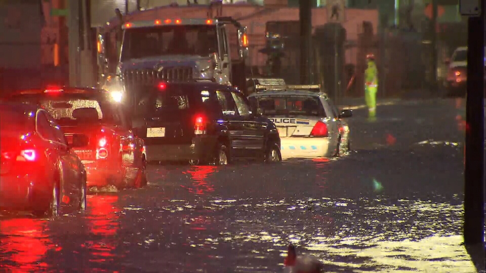
The rain has already caused Still Creek to overflow before dawn Thursday, and caused major flooding on Burnaby’s Still Creek Avenue.
Construction equipment could be seen floating down the street at one point, and the pooling water became so deep a police cruiser ended up stuck in the middle of the road.
Business owners had to clean up for the second time this week after dealing with flooding in the same area Tuesday.
"We are frustrated we have to go into the water up to our hip," said Jay Nand Singh, who works in the Still Creek area.
"It's nature," business owner Rob Atwal shrugged.
Environment Canada said 54 millimetres of rain had been measured at YVR as of 3 p.m., shattering the previous daily record set in 2001 at 38 millimetres.
In Vancouver, the wet weather caused a small landslide between the Commercial-Broadway and VCC-Clark SkyTrain stations.
TransLink said a Millennium Line shuttle train will running between the two stations for the rest of the day due to the track issue. Transit users will have to switch trains at Commercial.
The soggy weather is also a possible factor in a rockslide the closed the Sea to Sky near Horseshoe Bay overnight.
The Ministry of Transportation said most of the rocks were contained to the ditch, but some spilled into the northbound lanes. The area was cleared shortly after 4 a.m., and a geotechnical assessment is underway to investigate the cause.
Environment Canada expects the rainfall to end on Friday morning, when the storm moves out of the region.
The latest rainfall warning applies to Vancouver, Burnaby, New Westminster, Coquitlam, Maple Ridge, West Vancouver and North Vancouver.
A wind warning was also issued Thursday morning for those cities and for Richmond and Delta. Environment Canada says strong winds of up to 70 km/h are expected to blow though exposed areas Friday, and could cause damage to buildings.
BC Hydro says it's been getting storm-ready all year. It will have a team on standby and contractors have been notified.
"We do have a team of in-house meteorologists that track these weather systems, so we do know about them before they hit," BC Hydro's Kevin Aquino said.
In other areas of the South Coast, snowy roads are the main concern. Environment Canada has issued separate snowfall warnings for the Sea to Sky and Coquihalla highways, where snow already began accumulating overnight.
The weather agency said about 15 cm of snow had already fallen on the route to Whistler by around 5 a.m. Thursday, and up to 10 cm more is forecast over the course of the day.
"Prepare for quickly changing and deteriorating travel conditions," Environment Canada warned. "Visibility may be suddenly reduced at times in heavy snow. Surfaces such as highways, roads, walkways and parking lots may become difficult to navigate due to accumulating snow."
Up to 15 cm is forecast on the Coquihalla from Hope to Merritt as well. Drivers are advised to check conditions before heading out on the highway, to use winter tires and chains, and to adjust to winter driving behaviour.
To receive Environment Canada weather warnings and alerts straight to your phone, download CTV Vancouver's free Weather Watch app. Click here for more information, including how to download.
With files from CTV Vancouver's Sheila Scott and Emad Agahi
Environment Canada is forecasting 20-25 cm of snow along the Sea To Sky highway by day’s end.
— Emad Agahi (@emadagahiCTV) December 13, 2018
Here are the conditions now between Garibaldi and Whistler.@CTVVancouver
More: https://t.co/DPoGVQIRB5 pic.twitter.com/UYUHH6xa44
It’s getting light out and the water is rising along Still Creek Ave in Burnaby. A police cruiser is now stuck in the middle of the street. @CTVMorningLive @CTVVancouver pic.twitter.com/WLnOrp2sIO
— Sheila Scott (@Sheila_Scott) December 13, 2018


