Heavy snow forecast for B.C.'s Lower Mainland triggers warning against non-essential travel
Environment Canada is urging British Columbians to avoid non-essential travel with yet another snow storm forecast for the Lower Mainland this week.
Nearly the entire province is under a winter storm warning, and already icy road conditions left behind from previous storms could become even more dangerous.
Heavy snow and freezing rain is set to arrive Wednesday night and Thursday morning.
The latest round of intense winter weather will come as crews across the Lower Mainland are already playing catchup from a dump of snow Tuesday evening which caused icy conditions and long delays.
Boundary Road in Burnaby was significantly impacted.
Trucks struggled to navigate hills and streets that were under several centimetres of snow and slush.
Even service vehicles were no match for some of the conditions, unable to free buses that were stranded.
TransLink acknowledged some routes saw delays of three to four hours Tuesday, as multiple buses were stuck in the snow.
Dozens were also at a standstill on Vancouver's Granville Street Bridge.
Side streets were also treacherous, but it was the major routes that saw the biggest headaches for motorists and transit drivers.
"City doesn't clear all the roads so I come up the hill and the bus starts sliding back. It's a very dangerous situation,” said Sam Saini, a bus driver who was stuck for four hours.
Snow resumed falling early Wednesday morning, triggering a number of road closures on hills in Metro Vancouver.
The HOV lane of the Port Mann Bridge was also closed while crews used snow collars to prevent ice bombs.
ENVIRONMENT CANADA WARNINGS
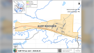
Almost all of British Columbia was put under an Environment Canada weather warning Wednesday morning.
Winter storm warnings were issued for Metro Vancouver and the Fraser Valley with hazardous conditions expected.
Vancouver, Burnaby, New Westminster, the North Shore, Coquitlam, Maple Ridge, Surrey, Langley, Richmond and Delta are all forecast to see 10 to 20 centimetres of snow.
Howe Sound and the Fraser Valley could be under 30 centimetres.
“Freezing rain likely in the Fraser Valley and possible over eastern Metro Vancouver. Reduced visibility in blowing snow in the Fraser Valley,” an advisory from Environment Canada said.
A low-pressure system will arrive Wednesday night, bringing heavy snow across the South Coast.
“On Thursday, snow will begin to transition to rain across Metro Vancouver as the system brings in milder air and temperatures begin to rise.”
The western and central Fraser Valley including Abbotsford and Chilliwack will likely see freezing rain as the cold air lingers.
The eastern Fraser Valley, including Hope, and Howe Sound are expected to remain cold enough that more snow will fall all day Thursday.
“Consider postponing non-essential travel until conditions improve,” warned Environment Canada.
With files from CTV Vancouver’s Penny Daflos and Mi-Jung Lee


CTVNews.ca Top Stories

Bodies found by U.S. authorities searching for missing B.C. kayakers
United States authorities who have been searching for a pair of missing kayakers from British Columbia since the weekend have recovered two bodies in the nearby San Juan Islands of Washington state.
Amid concerns over 'collateral damage' Trudeau, Freeland defend capital gains tax change
Facing pushback from physicians and businesspeople over the coming increase to the capital gains inclusion rate, Prime Minister Justin Trudeau and his deputy Chrystia Freeland are standing by their plan to target Canada's highest earners.
'It's discriminatory': Individuals refused entry to Ontario legislature for wearing keffiyeh
Individuals being barred from entering Ontario’s legislature while wearing a keffiyeh say the garment is part of their cultural identity— and the only ones making it political are the politicians banning it.
Tom Mulcair: Park littered with trash after 'pilot project' is perfect symbol of Trudeau governance
Former NDP leader Tom Mulcair says that what's happening now in a trash-littered federal park in Quebec is a perfect metaphor for how the Trudeau government runs things.
Saskatchewan households will continue to receive carbon tax rebate: Trudeau
Households in Saskatchewan will continue to receive Canada Carbon Rebate payments, despite the province refusing to remit natural gas levies to the federal government, Prime Minister Justin Trudeau said Tuesday.
'It's just so hard to let it go': Umar Zameer still haunted by death of Toronto police officer
'We hoped for this day, but we were scared that it would not never ever come because it took so long.' That’s what Umar Zameer, the man recently acquitted in the death of a Toronto police officer, told CTV News Toronto in a sit-down interview on Tuesday.
Senate expenses climbed to $7.2 million in 2023, up nearly 30%
Senators in Canada claimed $7.2 million in expenses in 2023, a nearly 30 per cent increase over the previous year.
Canucks goalie Thatcher Demko won't play in Game 2
The Vancouver Canucks will be without all-star goalie Thatcher Demko when they face the Nashville Predators in Game 2 of their first-round playoff series.
Pedestrian, baby injured after stroller struck and dragged by vehicle in Squamish, B.C.
Police say a baby and a pedestrian suffered non-life-threatening injuries after a vehicle struck a baby stroller and dragged it for two blocks before stopping in Squamish, B.C.
Shopping Trends
The Shopping Trends team is independent of the journalists at CTV News. We may earn a commission when you use our links to shop. Read about us.


Vancouver Island
-
Bodies found by U.S. authorities searching for missing B.C. kayakers
United States authorities who have been searching for a pair of missing kayakers from British Columbia since the weekend have recovered two bodies in the nearby San Juan Islands of Washington state.
-
B.C. places online harms bill on hold after agreement with Meta, X, TikTok, Snapchat
British Columbia has placed its proposed online harms legislation on hold after reaching an agreement with social media companies to “sit down in good faith” to find solutions on keeping people safer online.
-
Canucks goalie Thatcher Demko won't play in Game 2
The Vancouver Canucks will be without all-star goalie Thatcher Demko when they face the Nashville Predators in Game 2 of their first-round playoff series.
Kelowna
-
Homicide investigation underway after body found near Kelowna, B.C.
Major crime detectives in British Columbia are investigating a suspected homicide after a body was found in a remote area southeast Kelowna over the weekend.
-
Stolen snake named Milkshake returned to Kelowna pet store
A banana ball python that was stolen from a Kelowna pet store on Saturday has been returned unharmed, Mounties said.
-
Nurses rally at B.C. Interior hospital over security, staffing concerns
Nurses held a rally Wednesday at a hospital in the B.C. Interior that closed its emergency department more than a dozen times last year due to insufficient staff.
Edmonton
-
Fire engulfs old Edmonton municipal airport hangar
A historical hangar at the former Edmonton municipal airport beside the NAIT main campus was on fire Monday night.
-
ASIRT completes investigation into presumed death of man who fell into North Saskatchewan River
The Alberta Serious Incident Response Team (ASIRT) has wrapped up its investigation into the role of police in the presumed drowning death of a man earlier this month.
-
School bus driver charged after crash in northern Alberta
Five children and two adults were hospitalized after a school bus crash in northern Alberta on Monday.
Calgary
-
Calgary police chief weighs in on the complexities of protecting sex workers
Calgary's police chief is encouraging sex trade workers to report abuse, assaults and any other issues they encounter to the recently created Bad Date Line.
-
Calgary lawyer launches clothing line to champion Charter rights
A Calgary criminal defence lawyer has launched a clothing campaign to promote awareness about the Canadian Charter of Rights and Freedoms.
-
Missing Calgary man last seen in Tuscany, may be travelling in Chevy Cruze
Calgary police have released a photo of a missing man with hope the public can help locate him.
Lethbridge
-

Man sent to hospital with head injury following Lethbridge encampment assault
An assault over property at a Lethbridge encampment ended with a man in hospital suffering from a serious head injury.
-
Southern Alberta woman wins $2M on Western 6-49 lottery
A southern Alberta woman says she began to hyperventilate when she realized she had won $2 million.
-
Lethbridge green cart program a success one year in, city says
The City of Lethbridge is calling the first year of its curbside organics waste collection program a success.
Winnipeg
-

Manitoba fugitive among top 25 most-wanted in Canada
A Manitoba man wanted for attempted murder in connection with a shooting that injured two men in 2021 has made a national list for the most wanted criminals in the country.
-
RCMP arrest man who allegedly exposed himself at a Manitoba daycare
A 44-year-old man was arrested after he allegedly exposed himself to children and staff at a Manitoba daycare.
-
Veteran Niederreiter says this year's Jets have more pilots than 'passengers'
It was just over a year ago when Nino Niederreiter made a frank assessment of the Winnipeg Jets.
Regina
-

Suspect in 2023 Regina homicide joins Canada's Top 25 Most Wanted
Daniel "Juma" Drie Atem, wanted in connection to a Regina homicide last summer, is now one of Canada's Top 25 Most Wanted.
-
Saskatchewan households will continue to receive carbon tax rebate: Trudeau
Households in Saskatchewan will continue to receive Canada Carbon Rebate payments, despite the province refusing to remit natural gas levies to the federal government, Prime Minister Justin Trudeau said Tuesday.
-
One year after fatal collision, Regina council has final say on lower speed limit in Cathedral
Regina city councillors are set to consider lowering the speed limit in the Cathedral neighbourhood to 30 kilometres per hour on Wednesday.
Saskatoon
-

Saskatoon care home workers issue strike notice
Workers at group homes run by LutherCare Communities in Saskatoon have issued a strike notice after negotiations stalled between the union and employer.
-
Saskatchewan households will continue to receive carbon tax rebate: Trudeau
Households in Saskatchewan will continue to receive Canada Carbon Rebate payments, despite the province refusing to remit natural gas levies to the federal government, Prime Minister Justin Trudeau said Tuesday.
-
Sask. broker says halal mortgages are not a new concept in Canada
A Saskatoon mortgage broker says the federal government’s move to help Muslim Canadians get into the housing market by promoting halal mortgages is not such a radical idea — it’s helping families buy their first home without breaking their faith.
Toronto
-

'It's just so hard to let it go': Umar Zameer still haunted by death of Toronto police officer
'We hoped for this day, but we were scared that it would not never ever come because it took so long.' That’s what Umar Zameer, the man recently acquitted in the death of a Toronto police officer, told CTV News Toronto in a sit-down interview on Tuesday.
-
Teacher shortages see some Ontario high school students awarded perfect grades on midterm exams
Students at a high school in York Region have been awarded perfect marks on their midterm exams in three subjects – not because of their academic performances however, but because they had no teacher.
-
Man wanted in connection with deadly shooting in Toronto tops list of most wanted fugitives in Canada
A 35-year-old man wanted in connection with the murder of Toronto resident 29-year-old Sharmar Powell-Flowers nine months ago has topped the list of the BOLO program’s 25 most wanted fugitives across Canada, police announced Tuesday.
Montreal
-
RCMP uncovers alleged plot by 2 Montreal men to illegally sell drones, equipment to Libya
The RCMP says it has uncovered a plot by two men in Montreal to sell Chinese drones and military equipment to Libya illegally.
-
CAQ continues to lose ground to PQ in voting intentions; Liberals now in 2nd place: poll
The Coalition avenir Québec (CAQ) continues to lose ground to the Parti québécois (PQ) in voting intentions, according to Pallas Data's latest poll, with François Legault's party now in third place, behind the PQ and the Liberal Party (PLQ).
-
Province won't have to cover meal, alcohol costs of L.A. Kings games in Quebec City
The Quebec government will not have to cover the cost of meals and alcohol for Los Angeles Kings players coming to Quebec City for two exhibition games this fall.
Ottawa
-

NCC to close 1.2 km stretch of Queen Elizabeth Driveway to vehicles this summer
The National Capital Commission will close a section of Queen Elizabeth Driveway to vehicles seven days a week this summer, but only a shorter section of the road will be open for active transportation in July and August.
-
Ottawa murder suspect on list of Canada's top 25 most wanted fugitives
A Toronto man wanted in connection to a double homicide at an Ottawa shopping centre has been named one of the top 25 most wanted fugitives in Canada.
-
Here's where a new bowling alley is opening in Kanata
Bowlers will soon have a spot to throw strikes in Ottawa's west end. Oakville-based Splitsville has announced plans to open a location at the Kanata Centrum in the fall.
Atlantic
-

Police release name of teen who died following incident in Halifax mall parking lot
Halifax Regional Police has confirmed the identity of the teen who died following an incident in the parking lot of the Halifax Shopping Centre Monday.
-
'There was a lot of black smoke': Crane operator sounds alarm while trapped during highrise fire in Halifax
A tower crane operator alerted emergency crews after noticing a fire on a construction site in Halifax Tuesday morning.
-
Woman fighting cancer seeks donations for son with progressive disease
A Nova Scotia mother battling Stage 4 cancer is seeking donations to help her travel for treatment and adjust her home for her son who is living with a progressive disease that limits his mobility.
London
-

Candidates pound the pavement in ramp-up to Lambton-Kent-Middlesex by-election
Voters in Lambton Kent Middlesex go to the polls for a provincial by-election in a little more than a week now. When it comes to the key issue of affordability, they seem to be getting an earful from voters.
-
Bus rapid transit celebrates project milestone
London’s bus rapid transit project (BRT) is celebrating a milestone this week, with the arrival and installation of the first transit shelter in the city’s downtown core.
-
Car fire on Highway 401 sends one person to hospital
The Dutton/Dunwich Fire Department responded to the scene near mile marker 142 between Currie Road and Iona Road, after the vehicle caught fire.
Kitchener
-

$50,000 reward issued for Kitchener man’s alleged killer
Habiton Solomon is wanted in the fatal 2023 shooting of Joshua Tarnue in Kitchener.
-
Conestoga College hiring a group of 'lamb-scapers'
Conestoga says it’s the first college or university in Ontario to use sheep to maintain vegetation on campus.
-
Suspicious package scare leads to evacuation in Guelph
Several businesses in Guelph’s north end were evacuated Tuesday morning after a suspicious package was found at the Canada Post distribution centre on Woodlawn Road.
Northern Ontario
-

Sudbury police still trying to solve 2022 murder at downtown apartment
Sudbury police are finally releasing the identity of the 50-year-old man who was found shot to death inside his downtown apartment in 2022 as the investigation continues.
-
Collision closes the Kingsway in Sudbury
One person has been sent to hospital following a single-vehicle collision Tuesday at a busy intersection in Greater Sudbury.
-
North Bay doctor accused of assaulting patient, threatening another
A North Bay doctor is facing charges after allegedly assaulting a patient with a weapon and threatening another person at the hospital, police say.
N.L.
-

Rideshare platform Uber expands to Newfoundland and Labrador
Uber Technologies Inc. says it has brought its ridesharing platform to Newfoundland and Labrador.
-
Newfoundland director found creeping terror of 'The King Tide' in a tiny coastal town
Newfoundlander Christian Sparkes has shot several films around his home province, but with his new psychological thriller 'The King Tide' he saw an opportunity to wander into one unique town that had eluded him over the years.
-
2 people dead, 4 others make it to shore after vessel capsizes in Newfoundland
The Department of Fisheries and Oceans says two people were found dead and four others survived after a boat capsized off the west coast of Newfoundland.


