Flood updates: Rains ease in B.C., but heat could melt snowpack
With temperatures spiking this weekend, so too are worries about the increased risk of rising river levels in B.C.
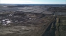
A high streamflow advisory remains in effect for the upper and lower Fraser River.
The Mission Gauge is at 5.55m. Levels are forecast to rise this weekend to around 5.65m, but stay below 6.0m into early next week.
Meanwhile, there is a flood warning for the Quesnel River and a flood watch for the Thompson River and Shuswap.
Hot temperatures are expected to make the late snowpack in the mountains melt more quickly, but that’s just one of several concerns being raised by the head of the River Forecast Centre.
“The first is the progression of runoff that has come from rainfall that we experienced earlier this week that has been travelling down from larger river system and we can still see that today or tomorrow,” said Dave Campbell.
Emergency Management B.C. says more than 530,000 sandbags have been deployed in the province.
“We have been working with the BC Wildfire Service crews to limit flood damage,” said Pader Brach of Emergency Management B.C.
“This weekend, we have around 130 BC Wildfire Service personnel on standby if needed (to assist with sandbagging),” he said.
Brach is also warning people about the risk of being around river banks.
“While I know people may want to seek out rivers during the hot weather over the weekend, river banks again are very dangerous right now and prone to collapse. High flows will also make waters more difficult to navigate,” he explained.
He said people should take precautions and be especially mindful of children and pets around rivers.
Campbell says the coming days are critical for the flood risk, but it’s hoped the province can turn a corner on the threat by late next week.


CTVNews.ca Top Stories

BREAKING
BREAKING Person engulfed in flames outside N.Y. courthouse where Trump trial underway, says CNN
A person was covered in flames outside the New York courthouse where former President Donald Trump's criminal hush money trial is underway, CNN reported on Friday.
Mandisa, Grammy award-winning 'American Idol' alum, dead at 47
Soulful gospel artist Mandisa, a Grammy-winning singer who got her start as a contestant on 'American Idol' in 2006, has died, according to a statement on her verified social media. She was 47.
Senators reject field trip to African Lion Safari amid elephant bill study
The Senate legal affairs committee has rejected a motion calling for members to take a $50,000 field trip to the African Lion Safari in southern Ontario to see the zoo's elephant exhibit.
CFIA monitoring for avian flu in Canadian dairy cattle after U.S. discoveries
The Canadian Food Inspection Agency is encouraging veterinarians to keep an eye out for signs of avian influenza in dairy cattle following recent discoveries of cases of the disease in U.S. cow herds.
She set out to find a husband in a year. Then she matched with a guy on a dating app on the other side of the world
Scottish comedian Samantha Hannah was working on a comedy show about finding a husband when Toby Hunter came into her life. What happened next surprised them both.
DEVELOPING
DEVELOPING G7 warns of new sanctions against Iran as world reacts to apparent Israeli drone attack
Group of Seven foreign ministers warned of new sanctions against Iran on Friday for its drone and missile attack on Israel, and urged both sides to avoid an escalation of the conflict.
'It could be catastrophic': Woman says natural supplement contained hidden painkiller drug
A Manitoba woman thought she found a miracle natural supplement, but said a hidden ingredient wreaked havoc on her health.
After hearing thousands of last words, this hospital chaplain has advice for the living
Hospital chaplain J.S. Park opens up about death, grief and hearing thousands of last words, and shares his advice for the living.
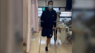
Vancouver firefighter in rehab at home after losing leg to flesh-eating infection overseas
A family trip took a frightening turn for Christopher Won when he was diagnosed with flesh-eating disease while in Hong Kong and now, after weeks of treatment overseas, the Vancouver firefighter is back home recovering.
Shopping Trends
The Shopping Trends team is independent of the journalists at CTV News. We may earn a commission when you use our links to shop. Read about us.


Vancouver Island
-

Woman killed, driver sought after hit-and-run crash in Duncan, B.C.
A woman is dead and police are searching for a suspect driver after a hit-and-run crash in Duncan, B.C.
-
Off-duty Mountie cleared of wrongdoing after cyclist seriously injured in Langford, B.C.
British Columbia's police watchdog has cleared an off-duty Mountie of wrongdoing after a cyclist suffered serious injuries in a collision with an unmarked police vehicle last month.
-
Coroner's inquest called into death of man killed in police shootout in Kamloops, B.C.
The British Columbia government has called for a coroner's inquest into the death of a 35-year-old Kamloops man who was killed in a shootout with police nearly six years ago.
Kelowna
-

Stolen snake named Milkshake returned to Kelowna pet store
A banana ball python that was stolen from a Kelowna pet store on Saturday has been returned unharmed, Mounties said.
-
Nurses rally at B.C. Interior hospital over security, staffing concerns
Nurses held a rally Wednesday at a hospital in the B.C. Interior that closed its emergency department more than a dozen times last year due to insufficient staff.
-
B.C. to add 240 complex-care housing units throughout province
British Columbia is planning to add 240 new units to its complex-care housing program, providing homes for people with mental-health and addictions challenges that overlap with other serious conditions.
Edmonton
-

Oilers host Los Angeles Kings on Monday in Game 1 of playoffs
The National Hockey League has confirmed the schedule for the first four Edmonton Oilers playoff games.
-
Voluntary water limits put in place in face of possible Alberta drought
More than three dozen of Alberta's largest water users have agreed with a provincial plan to cut back on water usage this year ahead of a severe drought expected this summer.
-
Worker dies after fall at north Edmonton construction site
Occupational Health and Safety (OHS) is investigating after a worker fell to their death earlier this week.
Calgary
-
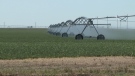
Voluntary water limits put in place in face of possible Alberta drought
More than three dozen of Alberta's largest water users have agreed with a provincial plan to cut back on water usage this year ahead of a severe drought expected this summer.
-
Medicine Hat woman charged after $60K stolen from Redcliff Legion
Mounties say a 32-year-old Medicine Hat woman has been charged in connection with the theft of $60,000 from the Redcliff Legion.
-
Calgary weather: Upcoming warm, dry conditions not helping drought conditions or wildfire risk
After a week centred around inconsistent weather conditions, Calgary will experience a reset and return to seasonal conditions over the weekend.
Lethbridge
-

Medicine Hat woman charged after $60K stolen from Redcliff Legion
Mounties say a 32-year-old Medicine Hat woman has been charged in connection with the theft of $60,000 from the Redcliff Legion.
-
Deterrent sentence possible, expert says, after trio convicted in connection to Coutts border blockade
Three men who helped lead and co-ordinate the 2022 border blockade at Coutts, Alta., have been found guilty of public mischief.
-
Central Alberta man arrested in connection with grandparent scam
Lethbridge police have arrested a Vermilion, Alta., man in connection with a 'grandparent scam' that took aim at a local senior.
Winnipeg
-

'It could be catastrophic': Woman says natural supplement contained hidden painkiller drug
A Manitoba woman thought she found a miracle natural supplement, but said a hidden ingredient wreaked havoc on her health.
-
Winnipeg Jets release Round 1 playoff schedule
The Winnipeg Jets have released its first round playoff schedule.
-
Winnipeg woman in hospital after being hit by tractor-trailer
One woman is in hospital after being hit by a tractor-trailer on Thursday night in North Kildonan.
Regina
-

New crash course focused on getting Sask. youth excited about journalism
Fifteen youth from a variety of backgrounds are taking on the monumental task of creating and performing a live radio broadcast with on seven days to prepare. The goal of the project is to get more youth excited about journalism.
-
SaskPower investing $13.5M in Regina's downtown electrical grid
SaskPower says it will be investing $13.5 million in an effort to improve downtown Regina's electrical grid.
-
'Opening soon': Highly anticipated return of Taco Bell to Regina approaching
Many in Regina have been waiting for Taco Bell's return to the Queen City since news of a return first broke in January 2023, an exact opening date isn't widely known yet, but it will be 'opening soon.'
Saskatoon
-

Saskatoon police committing three officers to curb crime in Pleasant Hill
The Saskatoon Police Service (SPS) is dedicating three officers to a specialized unit to help curb crime in the Pleasant Hill neighbourhood.
-
New Sask. dental hygienist degree program to offer strictly evening classes
A new dental hygienist degree program is launching at the University of Saskatchewan (U of S) in September to help meet a growing demand for oral health specialists.
-
Travel not recommended on several Sask. highways Friday morning
As a 'Colorado hybrid' system continues to bring snow and gusty winds to parts of Saskatchewan, highway conditions have continued to deteriorate over the past 48 hours.
Toronto
-
 WATCH
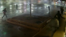
WATCHWATCH Video shows dramatic police takedown of carjacking suspects chased through parking lot north of Toronto
Police have released video footage of a dramatic takedown of a group of teens wanted in connection with an attempted carjacking in Markham earlier this month.
-
TTC service could be disrupted Monday if electrical and trades strike, CEO warns
The head of the TTC is warning of possible impacts to service on Monday if the union representing a group of more than 650 electrical and trades workers moves ahead with a strike.
-
'It was all my savings': Ontario woman loses $15K to fake Walmart job scam
A woman who recently moved to Canada from India was searching for a job when she got caught in an online job scam and lost $15,000.
Montreal
-
 BREAKING
BREAKING Next leader of Quebec Liberals will be known on June 14, 2025
The next leader of the Quebec Liberal Party will be known on June 14, 2025, according to a news release on the party's website.
-
Woman stabbed at motel in Montreal's west end
A 39-year-old woman was sent to hospital with serious injuries after police say she was stabbed inside a motel room in Montreal's west end Friday morning.
-
Young people 'tortured' if stolen vehicle operations fail, Montreal police tell MPs
One day after a Montreal police officer fired gunshots at a suspect in a stolen vehicle, senior officers were telling parliamentarians that organized crime groups are recruiting people as young as 15 in the city to steal cars so that they can be shipped overseas.
Ottawa
-

Gatineau, Que. teen accused of using social media to harass victim
A 13-year-old Gatineau, Que. boy is facing charges, including criminal harassment and distribution of child pornography, after allegedly using social media to harass the victim, according to police.
-
OPP reminds drone operators it's illegal to operate a drone near emergency sites following Hwy. 417 fatal crash
Ontario Provincial Police are reminding people that it is illegal to fly a drone over traffic collision sites, after drone footage captured over a fatal crash on Hwy. 417 in Ottawa appeared online.
-
Ontario man wanted after breaching 'statutory release'
The Repeat Offender Parole Enforcement Squad is asking the public for help locating a man in Ontario wanted on a Canada Wide Warrant after breaching their “statutory release.”
Atlantic
-

'Dangerous man' with firearm in Bible Hill in custody: N.S. RCMP
The RCMP says a 'dangerous man' with a firearm in Bible Hill, N.S., is in custody Friday morning.
-
Advocacy groups speak out against domestic violence comments by Nova Scotia minister
Several Nova Scotia groups that assist women are speaking out against comments on domestic violence by Justice Minister Brad Johns, and at least one is calling for his dismissal.
-
P.E.I. teen charged in connection with death of Tyson MacDonald to be sentenced Friday
The teen charged with mischief and obstruction in the investigation into the disappearance of Tyson McDonald is before a judge in Georgetown, P.E.I., Friday.
London
-
$80-million agreement for Central Elgin over annexed land for Volkswagen plant
The $80-million agreement announced Friday is said to include monetary compensation and infrastructure to grow industrial and residential tax bases.
-
Two people arrested in Port Elgin after vehicle theft in Hanover
Police in Hanover and Saugeen Shores have made an arrest after a citizen recognized a stolen vehicle from a social media post.
-
Human trafficking-related charges laid by London police
London police have charged a man from Manitoba with human trafficking-related charges. Police in the 600 block of Wellington Rd. near Wilkins Street when they saw a vehicle with stolen plates in a parking lot.
Kitchener
-

NDP compares proposed Wilmot land acquisition to Green Belt scandal ahead of town hall
Ontario NDP leader Marit Stiles is in Wilmot Township today railing against a plan to turn 770-acres of farmland into an industrial site. The NDP plans to host a town hall meeting, addressing the project, at the Wilmot Recreation Complex starting at 5 p.m.
-
Landlords reporting increase in tenants refusing to pay rent or leave
A property management company in Fergus is still cleaning up after they say a tenant trashed one of their units and refused to pay rent -- and they say it's not the only similar case they've dealt with recently.
-
Expansion coming to Cambridge nuclear manufacturing plant
An $80 million investment will result in a massive expansion and new jobs for a factory in Cambridge.
Northern Ontario
-

Sudbury police investigating threat found in high school bathroom stall
Sudbury police will have an increased presence at a local high school after two threatening messages were found in a bathroom stall.
-
Driver suffered medical emergency in fatal Highway 17 crash
One person has died as the result of a single-vehicle crash at a northern Ontario business on Highway 17 on Thursday afternoon, police say.
-
Northern Ont. man fined after decoy operation catches him hunting on private property
A Thunder Bay man has been fined $2,000 after he was caught in a decoy operation hunting on private land.
N.L.
-

N.L. gardening store revives 19th century seed-packing machine
Technology from the 19th century has been brought out of retirement at a Newfoundland gardening store, as staff look for all the help they can get to fill orders during a busy season.
-
500 Newfoundlanders wound up on the same cruise and it turned into a rocking kitchen party
A Celebrity Apex cruise to the Caribbean this month turned into a rocking Newfoundland kitchen party when hundreds of people from Canada's easternmost province happened to be booked on the same ship.
-
Protest averted as Newfoundland and Labrador premier helps reach pricing deal on crab
A pricing agreement has been reached between crab fishers and seafood processors that will allow for Newfoundland and Labrador's annual crab fishery to get started.


