B.C. set 8 more temperature records on Friday, according to Environment Canada
For the fourth day in a row, several B.C. communities set high-temperature records on Friday.
Preliminary data from Environment and Climate Change Canada shows the following eight areas recorded new record highs for July 29:
- Cache Creek area – new record of 41.2, old record of 39.2 set in 2018
- Clinton area – new record of 34.7, old record of 33.3 set in 2018
- Kamloops area – new record of 37.9, old record of 37.6 set in 1998
- Lillooet area – new record of 40.1, old record of 39.8 set in 2018
- Lytton area – new record of 42.2, old record of 41.4 set in 2018
- Merritt area – new record of 37.2, old record of 37 set in 2003
- Nelson area – new record of 38.6, old record of 38.5 set in 2003
- Trail area – new record of 40, old record of 39.3 set in 2014
For Lytton and Clinton, the latest highs represent the third consecutive days on which a record was set. For Cache Creek, Friday was the third record-setting day in the last four.
Armel Castellan, a meteorologist and emergency planner for ECCC, told CTV News more temperature records are possible on Sunday and Monday as the heat wave stretches on.
Temperatures are expected to begin cooling off on Monday, but many areas in the Interior won't see daily highs drop out of the 30s until Wednesday, or even Thursday in the southeastern part of the province, Castellan said.
Daily temperature records are considered preliminary because they haven't gone through Environment Canada's quality assurance and quality control process, which typically takes several weeks, according to Castellan. He said there's "always a little bit of a chance" that weather sensors are malfunctioning, but it's very rare for preliminary records to be overturned.
Castellan stressed that when temperatures begin to decline, the effects of heat-related illness can continue. He encouraged B.C. residents to continue to check on vulnerable people in their lives throughout the coming week.
Most of the province has been under a heat warning since Monday, July 25, and Castellan said he expects the warnings to remain in place through the long weekend, with the decline in temperatures proceeding from north to south and west to east through the province beginning Monday night or Tuesday.
As temperatures fall, unstable air has the potential to lead to thunderstorms, increasing the likelihood of new wildfires in the wake of the heat wave, Castellan said.


CTVNews.ca Top Stories

Quebec nurse had to clean up after husband's death in Montreal hospital
On a night she should have been mourning, a nurse from Quebec's Laurentians region says she was forced to clean up her husband after he died at a hospital in Montreal.
'Anything to win': Trudeau says as Poilievre defends meeting protesters
Prime Minister Justin Trudeau is accusing Conservative Leader Pierre Poilievre of welcoming 'the support of conspiracy theorists and extremists,' after the Conservative leader was photographed meeting with protesters, which his office has defended.
'My stomach dropped': Winnipeg man speaks out after being criminally harassed following single online date
A Winnipeg man said a single date gone wrong led to years of criminal harassment, false arrests, stress and depression.
What is changing about Canada's capital gains tax and how does it impact me?
The federal government's proposed change to capital gains taxation is expected to increase taxes on investments and mainly affect wealthy Canadians and businesses. Here's what you need to know about the move.
Bank of Canada officials split on when to start cutting interest rates
Members of the Bank of Canada's governing council were split on how long the central bank should wait before it starts cutting interest rates when they met earlier this month.
Pilot reported fire onboard plane carrying fuel, attempted to return to Fairbanks just before crash
One of the two pilots aboard an airplane carrying fuel reported there was a fire on the airplane shortly before it crashed and burned outside Fairbanks, killing both people on board, a federal aviation official said Wednesday.
Police tangle with students in Texas and California as wave of campus protest against Gaza war grows
Police tangled with student demonstrators in Texas and California while new encampments sprouted Wednesday at Harvard and other colleges as school leaders sought ways to defuse a growing wave of pro-Palestinian protests.
'One of the single most terrifying things ever': Ontario couple among passengers on sinking tour boat in Dominican Republic
A Toronto couple are speaking out about their 'extremely dangerous' experience on board a sinking tour boat in the Dominican Republic last week.
7 surveillance videos linked to extortions of South Asian home builders in Edmonton released
The Edmonton Police Service has released a number of surveillance videos related to a series of extortion cases in the city now dubbed 'Project Gaslight.'
Shopping Trends
The Shopping Trends team is independent of the journalists at CTV News. We may earn a commission when you use our links to shop. Read about us.


Vancouver Island
-

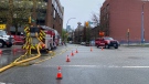
'It was instant karma': Viral video captures failed theft attempt in Nanaimo, B.C.
Mounties in Nanaimo, B.C., say two late-night revellers are lucky their allegedly drunken escapades weren't reported to police after security cameras captured the men trying to steal a heavy steel sign from a downtown business.
-
RCMP officers 'refused' to provide evidence to Crown to assist drug, firearms prosecution: report
Crown counsel was unable to approve "significant" drug and weapons charges stemming from an arrest in Quesnel, B.C., last year because the officers involved "refused to provide any evidence," according to a report from the province’s police watchdog.
-
B.C. man rescues starving dachshund trapped in carrier: BC SPCA
An emaciated dachshund is now recovering thanks to a Good Samaritan who found the pup near a biking trail in Kelowna, according to the BC SPCA.
Kelowna
-

B.C. man rescues starving dachshund trapped in carrier: BC SPCA
An emaciated dachshund is now recovering thanks to a Good Samaritan who found the pup near a biking trail in Kelowna, according to the BC SPCA.
-
Search crews called in after missing Kelowna senior's truck found
Search and rescue crews have been called in after a vehicle belonging to a missing senior was located near a rural intersection outside of Kelowna Tuesday.
-
Homicide investigation underway after body found near Kelowna, B.C.
Major crime detectives in British Columbia are investigating a suspected homicide after a body was found in a remote area southeast Kelowna over the weekend.
Edmonton
-

Measles case in Edmonton prompts exposure warning
Alberta Health Services issued a measles alert in Edmonton Wednesday after confirming a case.
-
7 surveillance videos linked to extortions of South Asian home builders in Edmonton released
The Edmonton Police Service has released a number of surveillance videos related to a series of extortion cases in the city now dubbed 'Project Gaslight.'
-
8.9% property tax approved by Edmonton council
Edmonton city council unanimously agreed on an 8.9-per cent property tax increase Tuesday evening.
Calgary
-

'Disingenuous and misleading': Calgary mayor, province at odds over plan to lower utility bills
Calgary's mayor is sparring with the Government of Alberta over the rollout of new legislation meant to lower utility bills in Calgary.
-
Quest School's new Sunalta campus focuses on high school student learning and an adult transition program
Quest School has expanded to a second campus in Calgary that is an innovative learning hub for high school students and young adults with moderate to severe developmental disabilities.
-
Bell no longer a Calgary Stampede sponsor after nearly 20 years
Bell Canada, the parent company of CTV News, is no longer a sponsor of the Calgary Stampede.
Lethbridge
-

Alberta, B.C. preparing for early start to wildfire season
Wildfires in Alberta and B.C. appear to be getting off to an early start this year. Both province's wildfire services are doing what they can to prepare for what's expected to be a tough summer.
-
Man sent to hospital with head injury following Lethbridge encampment assault
An assault over property at a Lethbridge encampment ended with a man in hospital suffering from a serious head injury.
-
Southern Alberta woman wins $2M on Western 6-49 lottery
A southern Alberta woman says she began to hyperventilate when she realized she had won $2 million.
Winnipeg
-

Manitoba government tables bill to end ban on homegrown recreational cannabis
Manitoba is planning to lift its ban on the home growing of recreational cannabis.
-
'I just wanted to stand out': Winnipeg Jets fan goes viral for wearing salmon shirt at Whiteout
A Winnipeg Jets fan found a unique way to stand out amid the Winnipeg Whiteout; he wore a salmon-coloured shirt.
-
Child dies following collision with trailer: Brandon police
A four-year-old child has died following a collision with a trailer in Brandon, Man.
Regina
-

'Learn to walk again': Sask. doctor tells story of miracle recovery from deadly heart condition
It was a powerful morning at Regina's Conexus Arts Centre Wednesday, where the Lieutenant Governor hosted the annual Saskatchewan Prayer Breakfast and a provincial doctor told his story of survival from a deadly heart condition.
-
Throwing star, crossbow found during Sask. RCMP searches at George Gordon FN, Punnichy
A throwing star and crossbow were among the seizures by police as part of a drug trafficking investigation on George Gordon First Nation and in Punnichy, Sask. last week.
-
Sask. police caught 454 impaired drivers in March: SGI
Saskatchewan police caught 454 impaired drivers around the province in March. Of those, 142 are facing Criminal Code charges and the other 312 faced licence suspensions, according to a news release from Saskatchewan Government Insurance (SGI).
Saskatoon
-

Sask. woman fights to find out who had her apprehended for a psych. assessment
A Saskatchewan woman who was taken for an involuntary mental health assessment is entitled to find out who had her committed, a provincial court judge has ruled.
-
Sask. judge sets date to decide if evidence in fatal THC-impaired driving case is admissible
A date has been set for a Saskatoon judge to decide whether a woman’s admission to consuming drugs can be used in her trial.
-
Punched, kicked, spat on: Saskatoon Transit workers call for help after violent assaults
The union representing the city’s bus drivers says violence against transit workers is out of control.
Toronto
-

Speed limits to increase on some sections of Ontario highways, province says
The Ontario government says it will be raising the speed limit along certain stretches of provincial highways soon, including Highway 401 and Highway 403.
-
New condo sales in the Toronto area hit low not seen since financial crisis
New condo sales in the Toronto region dropped to the lowest quarterly total since the financial crisis in 2009 amid high interest rates and affordability issues, a new report has found.
-
'One of the single most terrifying things ever': Ontario couple among passengers on sinking tour boat in Dominican Republic
A Toronto couple are speaking out about their 'extremely dangerous' experience on board a sinking tour boat in the Dominican Republic last week.
Montreal
-
Quebec nurse had to clean up after husband's death in Montreal hospital
On a night she should have been mourning, a nurse from Quebec's Laurentians region says she was forced to clean up her husband after he died at a hospital in Montreal.
-
REM delayed: Stations in West Island, North Shore now opening in 2025
Officials for Montreal's REM line confirmed that the lines to the West Island and the North Shore are being delayed and won't open until 2025.
-
Quebec grants $40 million for cleanup of Montreal Olympic Stadium after fire
The Quebec government has awarded the organization that manages Montreal's Olympic Stadium up to $40 million to pay for repairs and decontamination after a March 21 fire.
Ottawa
-

NCC buys golf course near Gatineau Park for $3.9 million
The National Capital Commission has purchased the old Dunnderosa Golf Course in Chelsea, Que., as part of its plan to acquire private properties in Gatineau Park.
-
Residents raise concerns about plan for Inuit women's shelter in Ottawa's south end
Residents in Ottawa's Hunt Club neighbourhood are raising concerns about plans to build an Inuit women's shelter in the south end neighbourhood.
-
Eastern Ont. knitters make 80 peacekeeper 'Izzy Dolls' for D-Day anniversary
Volunteers in Perth, Ont. have knit small peacekeeper "Izzy Dolls" that will be sent to France in commemoration of the 80th anniversary of D-Day and the Battle of Normandy.
Atlantic
-

Funeral to be held Wednesday for 16-year-old Halifax homicide victim
A funeral will be held Wednesday afternoon in Bedford, N.S., for a 16-year-old boy who died earlier this week following an incident near the Halifax Shopping Centre.
-
N.S. man wins $1.5M through Atlantic Lottery
A Cape Breton man won $1.5 million after buying $200-worth of Atlantic Lottery Scratch’N Win tickets.
-
Police presence at Lower, Middle Sackville, N.S., schools Wednesday afternoon
RCMP officers were seen at three schools in Lower and Middle Sackville, N.S., Wednesday afternoon.
London
-

Nuclear waste referendum date set for October
Residents in the Municipality of South Bruce will decide whether they want to host Canada’s first permanent nuclear waste storage facility this October.
-
How do U.S. decisions about TikTok impact Canada?
U.S. President Joe Biden has signed a bill that will force TikTok to be sold or be banned in his country, but what does it mean for Canada?
-
'I think 110 is fast enough': Speed limit to increase on some sections of 400 series highways
The speed you travel on sections of 400 series highways in our region is increasing. The province says it will raise the speed limit to 110 km/h on multiple sections, including some in the London region.
Kitchener
-

Undisclosed project filming in Cambridge today
Expect delays on Queen Street in Cambridge today as film crew shoots in the area.
-
Pedestrian seriously hurt after crash in Kitchener
A pedestrian had to be taken to an out-of-region hospital following a crash in Kitchener.
-
Grand River and St. Mary's hospitals could merge in 2025
Grand River Hospital and St. Mary’s General Hospital are looking to merge into a single new hospital organization by the spring of 2025.
Northern Ontario
-

Northern Ont. lawyer who abandoned clients in child protection cases disbarred
A North Bay, Ont., lawyer who abandoned 15 clients – many of them child protection cases – has lost his licence to practise law.
-
'My stomach dropped': Winnipeg man speaks out after being criminally harassed following single online date
A Winnipeg man said a single date gone wrong led to years of criminal harassment, false arrests, stress and depression.
-
OPP and Treaty Three police lay murder charge in northwestern Ont.
The Ontario Provincial Police, in partnership with the Treaty Three Police Service, have charged a suspect with murder following a homicide in a remote northwestern Ontario community.
N.L.
-

Rideshare platform Uber expands to Newfoundland and Labrador
Uber Technologies Inc. says it has brought its ridesharing platform to Newfoundland and Labrador.
-
Newfoundland director found creeping terror of 'The King Tide' in a tiny coastal town
Newfoundlander Christian Sparkes has shot several films around his home province, but with his new psychological thriller 'The King Tide' he saw an opportunity to wander into one unique town that had eluded him over the years.
-
2 people dead, 4 others make it to shore after vessel capsizes in Newfoundland
The Department of Fisheries and Oceans says two people were found dead and four others survived after a boat capsized off the west coast of Newfoundland.


