Atmospheric river ranking system still not implemented in B.C.
VANCOUVER -
Months after atmospheric rivers triggered a catastrophic series of landslides and floods, there seems to have been little progress in implementing a ranking system for the weather events despite a timeline set out by the public safety minister.
In November, when he was asked about a one to five categorization system developed by American researchers, Mike Farnworth seemed keen on the idea.
"We are very pleased that the federal government is putting in place, is working with Environment Canada, a ranking system for the atmospheric rivers. That will assist, I think, us greatly in getting an understanding of exactly what the nature of an atmospheric river is," Farnworht said during a Nov. 22 news conference.
"It is, obviously, a new term that I think most of us are now becoming familiar with. They have a ranking system in the states. That will allow us to, I think, prepare more effectively. My expectation is, from what I've been told, that will be coming, looking to be implemented at the beginning of January 2022."
But when CTV News asked about the implementation as another series of atmospheric rivers was barrelling toward B.C., the public safety ministry directed us to Environment and Climate Change Canada, citing a new, vague timeline of having a system sometime “in the future.”
The meteorological agency said they have their own internal colour-coded forecasting tool, but described it as having limitations and being a work in progress. A meteorologist said they send their predictions to provincial officials, but an EMBC communications officer said they had not received a ranking on Monday afternoon.
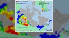
AMERICAN RESEARCHERS ANTICIPATE LEVEL 3 EVENT
While a warning preparedness meteorologist with ECCC described the scale as “not quite ready” for public distribution, American researchers specializing in atmospheric rivers published an analysis and prediction for a Level 3 event.
“Flooding is possible in western Washington and southwestern B.C. due to the combination of heavy rainfall, moist soils, and existing snowpack at lower elevations,” wrote analysts at the Centre for Western Weather and Water Extremes at the Scripps Institute at UC San Diego.
While no government agencies have officially adopted the Scripps Institute’s scale, it’s already being cited and used as reference by meteorologist and planners who follow their forecasts and projections.
Much like a tornado or hurricane ranking system, the analysts say the forecast can change while providing a quick and easy to understand snapshot of the conditions for the general public.
ECCC said they’re working on several measures to better communicate weather events and risks to the public as part of years-long planning and development work.
WHAT ABOUT ALERT READY?
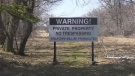
Another issue that saw the province in the hot seat during November’s lethal flooding and slides was the reluctance of emergency officials to use the Alert Ready system, which had a narrow set of parameters for its implementation amid confusion over how the emergency text alert technology works.
Less than two weeks after the flooding, the B.C. RCMP used the Alert Ready system during an active shooter situation in Prince George, marking the first time Alert Ready had been used in B.C. in four years, while other provinces use the technology dozens of times per year.
When CTV News asked whether Emergency Management B.C. was willing to trigger Alert Ready texts if the weather called for it, and they said they are.
“Should a community, or communities, feel there is an imminent threat to life or public safety, the Province stands ready to use the Alert Ready program and issue what we call a broadcast intrusive alert,” they wrote in an email. “Emergency Management B.C. reviews every significant event and will review these events and the lessons we need to learn to be better prepared for emergencies.”


CTVNews.ca Top Stories

Quebec nurse had to clean up after husband's death in Montreal hospital
On a night she should have been mourning, a nurse from Quebec's Laurentians region says she was forced to clean up her husband after he died at a hospital in Montreal.
Cuban government apologizes to Montreal-area family after delivering wrong body
Cuba's foreign affairs minister has apologized to a Montreal-area family after they were sent the wrong body following the death of a loved one.
What is changing about Canada's capital gains tax and how does it impact me?
The federal government's proposed change to capital gains taxation is expected to increase taxes on investments and mainly affect wealthy Canadians and businesses. Here's what you need to know about the move.
'Anything to win': Trudeau says as Poilievre defends meeting protesters
Prime Minister Justin Trudeau is accusing Conservative Leader Pierre Poilievre of welcoming 'the support of conspiracy theorists and extremists,' after the Conservative leader was photographed meeting with protesters, which his office has defended.
Northern Ont. lawyer who abandoned clients in child protection cases disbarred
A North Bay, Ont., lawyer who abandoned 15 clients – many of them child protection cases – has lost his licence to practise law.
'One of the single most terrifying things ever': Ontario couple among passengers on sinking tour boat in Dominican Republic
A Toronto couple are speaking out about their 'extremely dangerous' experience on board a sinking tour boat in the Dominican Republic last week.
Boeing's financial woes continue, while families of crash victims urge U.S. to prosecute the company
Boeing said Wednesday that it lost US$355 million on falling revenue in the first quarter, another sign of the crisis gripping the aircraft manufacturer as it faces increasing scrutiny over the safety of its planes and accusations of shoddy work from a growing number of whistleblowers.
Bank of Canada officials split on when to start cutting interest rates
Members of the Bank of Canada's governing council were split on how long the central bank should wait before it starts cutting interest rates when they met earlier this month.
Fair in Ontario, flurries in Labrador: Weather systems make for an erratic spring
It's no secret that spring can be a tumultuous time for Canadian weather, and as an unseasonably mild El Nino winter gives way to summer, there's bound to be a few swings in temperature that seem out of the ordinary. From Ontario to the Atlantic, though, this week is about to feel a little erratic.
Shopping Trends
The Shopping Trends team is independent of the journalists at CTV News. We may earn a commission when you use our links to shop. Read about us.


Vancouver Island
-

'It was instant karma': Viral video captures failed theft attempt in Nanaimo, B.C.
Mounties in Nanaimo, B.C., say two late-night revellers are lucky their allegedly drunken antics weren't reported to police after security cameras captured the men trying to steal a heavy sign from a downtown business.
-
Woman who killed Reena Virk calls new TV series disrespectful to victim
The B.C. woman convicted of killing Reena Virk described the TV series dramatizing the notorious 1997 murder as disrespectful to the victim and her family.
-
RCMP officers 'refused' to provide evidence to Crown to assist drug, firearms prosecution: report
Crown counsel was unable to approve "significant" drug and weapons charges stemming from an arrest in Quesnel, B.C., last year because the officers involved "refused to provide any evidence," according to a report from the province’s police watchdog.
Kelowna
-

B.C. man rescues starving dachshund trapped in carrier: BC SPCA
An emaciated dachshund is now recovering thanks to a Good Samaritan who found the pup near a biking trail in Kelowna, according to the BC SPCA.
-
Search crews called in after missing Kelowna senior's truck found
Search and rescue crews have been called in after a vehicle belonging to a missing senior was located near a rural intersection outside of Kelowna Tuesday.
-
Homicide investigation underway after body found near Kelowna, B.C.
Major crime detectives in British Columbia are investigating a suspected homicide after a body was found in a remote area southeast Kelowna over the weekend.
Edmonton
-

Nurse practitioners to make 80% as much as family doctors for publicly-funded primary care
The Alberta government says it will pay nurse practitioners 80 per cent of what family doctors are paid – if they want to practice comprehensive primary care.
-
Measles case in Edmonton prompts exposure warning
Alberta Health Services issued a measles alert in Edmonton Wednesday after confirming a case.
-
7 surveillance videos linked to extortions of South Asian home builders in Edmonton released
The Edmonton Police Service has released a number of surveillance videos related to a series of extortion cases in the city now dubbed 'Project Gaslight.'
Calgary
-

Calgary rezoning debate continues into day three
Three days into Calgary's public hearing on proposed rezoning and nearly 200 speakers later, some councillors say there's a clear pattern when it comes to what they're hearing from people presenting.
-
Auburn Bay community members rally around grieving widow, three young children
Residents of one southeast Calgary neighbourhood have raised thousands of dollars to support a family grieving the losses of a father and grandfather.
-
Fire risk for southern Alberta high: Natural Resources Canada
It’s not even May 1 and the fire risk for southern Alberta is already alarming.
Lethbridge
-
Fire risk for southern Alberta high: Natural Resources Canada
It’s not even May 1 and the fire risk for southern Alberta is already alarming.
-
Lethbridge’s Whoop-Up Days accepting applications to be in 2024 parade
Whoop-Up Days is still four months away, but applications to be in this year’s parade are now open.
-
Lethbridge added 28 physicians over the past year, AHS continues search for more
Lethbridge has added 28 physicians over the past year, according to a quarterly report published by the College of Physicians and Surgeons of Alberta.
Winnipeg
-
'We are not here for tree preservation': Development company appealing latest decision with Lemay Forest
A new fight is gearing up at city hall over Lemay Forest.
-
'I just wanted to stand out': Winnipeg Jets fan goes viral for wearing salmon shirt at Whiteout
A Winnipeg Jets fan found a unique way to stand out amid the Winnipeg Whiteout; he wore a salmon-coloured shirt.
-
Eradication of Manitoba's wild pigs 'just not realistic' expert warns, but new funding will help
A Canadian expert warns eradicating an ever-increasing population of wild pigs in Manitoba likely won't be possible, but new money from the provincial and federal governments will help in the fight to get the invasive species under control.
Regina
-

Revitalization of Regina's Dewdney Avenue to begin next week
Beginning April 29, Dewdney Avenue between Albert Street and Broad Street will see a number of construction sites.
-
'Learn to walk again': Sask. doctor tells story of miracle recovery from deadly heart condition
It was a powerful morning at Regina's Conexus Arts Centre Wednesday, where the Lieutenant Governor hosted the annual Saskatchewan Prayer Breakfast and a provincial doctor told his story of survival from a deadly heart condition.
-
Throwing star, crossbow found during Sask. RCMP searches at George Gordon FN, Punnichy
A throwing star and crossbow were among the seizures by police as part of a drug trafficking investigation on George Gordon First Nation and in Punnichy, Sask. last week.
Saskatoon
-

This Saskatchewan woman is helping fill bellies and hearts with a free grocery store
Darlene Hartshorn is a mother and grandmother from Warman who is making a difference by helping those who need a hand up.
-
Sask. woman fights to find out who had her apprehended for a psych. assessment
A Saskatchewan woman who was taken for an involuntary mental health assessment is entitled to find out who had her committed, a provincial court judge has ruled.
-
Boeing invests $17 million in Sask. aviation program
International aircraft giant Boeing has made a multi-million dollar commitment to the Saskatchewan Indian Institute of Technology (SIIT) to help address shortages in the aviation industry.
Toronto
-

Speed limits to increase on some sections of Ontario highways, province says
The Ontario government says it will be raising the speed limit along certain stretches of provincial highways soon, including Highway 401 and Highway 403.
-
Driver dead after vehicle collides with parked trailer in Mississauga
A delivery truck driver is dead after a collision in an industrial complex in Mississauga Wednesday afternoon.
-
Toronto police release videos of suspect who allegedly bumped into stranger, stabbed them
Toronto police have released videos of a suspect who allegedly stabbed a stranger he bumped into in the city’s Mount Dennis neighbourhood earlier this week.
Montreal
-
Quebec nurse had to clean up after husband's death in Montreal hospital
On a night she should have been mourning, a nurse from Quebec's Laurentians region says she was forced to clean up her husband after he died at a hospital in Montreal.
-
REM delayed: Stations in West Island, North Shore now opening in 2025
Officials for Montreal's REM line confirmed that the lines to the West Island and the North Shore are being delayed and won't open until 2025.
-
Cuban government apologizes to Montreal-area family after delivering wrong body
Cuba's foreign affairs minister has apologized to a Montreal-area family after they were sent the wrong body following the death of a loved one.
Ottawa
-

NCC buys golf course near Gatineau Park for $3.9 million
The National Capital Commission has purchased the old Dunnderosa Golf Course in Chelsea, Que., as part of its plan to acquire private properties in Gatineau Park.
-
Can cars and bikes fit on the Queen Elizabeth Driveway and Colonel By Drive?
There are questions about how the National Capital Commission might fit bike lanes on the Queen Elizabeth Driveway and Colonel By Drive.
-
Eastern Ont. knitters make 80 peacekeeper 'Izzy Dolls' for D-Day anniversary
Volunteers in Perth, Ont. have knit small peacekeeper "Izzy Dolls" that will be sent to France in commemoration of the 80th anniversary of D-Day and the Battle of Normandy.
Atlantic
-

A community in mourning: 16-year-old killed at Halifax parkade remembered
Community members gathered at a mosque for Ahmad Al Marrach — a 16-year-old murder victim — for his funeral on Wednesday.
-
N.S. man wins $1.5M through Atlantic Lottery
A Cape Breton man won $1.5 million after buying $200-worth of Atlantic Lottery Scratch’N Win tickets.
-
'Life was not fair to him': Daughter of N.B. man exonerated of murder remembers him as a kind soul
The daughter of a New Brunswick man recently exonerated from murder, is remembering her father as somebody who, despite a wrongful conviction, never became bitter or angry.
London
-

'You made me look for money while he bled on the floor': Man sentenced in manslaughter case nearly a decade after botched robbery
Nine years after a London, Ont. man was shot to death in a botched robbery at his home, the man responsible for the shooting was given a prison sentence on Wednesday.
-
Protest at shuttered auto parts maker over unpaid severance
Frustrated employees of Wescast’s shuttered auto parts manufacturer in Wingham, Ont. will be sending a message to their former ownership on Thursday.
-
'I think 110 is fast enough': Speed limit to increase on some sections of 400 series highways
The speed you travel on sections of 400 series highways in our region is increasing. The province says it will raise the speed limit to 110 km/h on multiple sections, including some in the London region.
Kitchener
-

Ont. teacher says she's being forced to switch pharmacies to maintain medication coverage
A Waterloo, Ont. teacher says she’s frustrated after learning the arthritis medication she depends on is no longer covered under her benefits plan and she'll have to switch pharmacies to avoid paying out of pocket.
-
Film crew transforms Cambridge pizza shop
A Cambridge pizza restaurant got a temporary makeover this week, turning into a fictitious donut shop as part of a film production.
-
Pedestrian seriously hurt after crash in Kitchener
A pedestrian had to be taken to an out-of-region hospital following a crash in Kitchener.
Northern Ontario
-

Northern Ont. lawyer who abandoned clients in child protection cases disbarred
A North Bay, Ont., lawyer who abandoned 15 clients – many of them child protection cases – has lost his licence to practise law.
-
Garden River chief meets with disgruntled band members over payout concerns
Some members of the Garden River First Nation are demanding answers regarding the disbursement of the Robinson-Huron Treaty settlement funds.
-
'My stomach dropped': Winnipeg man speaks out after being criminally harassed following single online date
A Winnipeg man said a single date gone wrong led to years of criminal harassment, false arrests, stress and depression.
N.L.
-

Rideshare platform Uber expands to Newfoundland and Labrador
Uber Technologies Inc. says it has brought its ridesharing platform to Newfoundland and Labrador.
-
Newfoundland director found creeping terror of 'The King Tide' in a tiny coastal town
Newfoundlander Christian Sparkes has shot several films around his home province, but with his new psychological thriller 'The King Tide' he saw an opportunity to wander into one unique town that had eluded him over the years.
-
2 people dead, 4 others make it to shore after vessel capsizes in Newfoundland
The Department of Fisheries and Oceans says two people were found dead and four others survived after a boat capsized off the west coast of Newfoundland.


