Wind warnings issued for much of B.C.'s South Coast have ended, but not before gusts knocked out power to tens of thousands and toppled countless trees across the region.
More than 75,000 customers in the Lower Mainland and Fraser Valley were affected by outages on Friday afternoon as the tail of the second storm this week hit the area with sudden wind gusts.
The wind died down on Friday evening, but the respite may be short lived, as a typhoon-fuelled windstorm is approaching the coast. The third storm is expected to make landfall on Saturday.
BC Hydro warned that the outages caused by the storms were expected to increase until strong winds rushing through the area abate, and said that although they have more than 100 technicians working in the field, some customers may be without power through the night.
Data from BC Hydro posted Friday evening showed that crews were working to restore 185 outages across the province. The outages span from the southern tip of Vancouver Island to B.C.'s Central Interior.
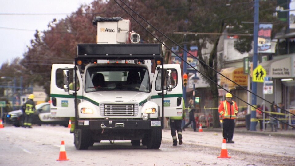
Emergency crews were kept on their toes as trees toppled across the region, including one that crushed a car in Burnaby, and several that blocked roadways in East Vancouver.
Several large trees blocked the road after falling near Kingsway and Joyce Street in Vancouver.
The falling trees also took down bus trolley lines, and one tree fell on a high school student in Surrey. The boy was taken to hospital where he died of his injuries.
The wind also knocked down two trees at an elementary school in Delta while students were outside during lunch hour, but fortunately no one was injured.
TransLink reported that the weather forced multiple bus routes in Vancouver, Burnaby, Delta, White Rock, Surrey and Steveston to detour.
Environment Canada said by 1 p.m. peak winds reached 72 km/h in Vancouver, while gusts reached 103 km/h on Saturna Island.
In Tsawwassen, where gusts were measured at 89 km/h, several ferries on major routes were held at the dock Friday afternoon because of the wind.
The Coastal Inspiration ferry due to sail between Tsawwassen and Duke Point station in Nanaimo was being held because of the severe weather, and the Spirit of Vancouver Island headed from Victoria to Tsawwassen was delayed over severe winds.
Ferries between Tsawwassen and the Southern Gulf Islands were cancelled for the remainder of the day.
BC Ferries is reminding customers to check its website before leaving home, in case their planned sailings are delayed or cancelled.
High winds prompted the cancellation of multiple flights through Harbour Air between the Lower Mainland, Vancouver Island and the Gulf Islands.
Although Vancouver International Airport said operations weren't impacted by the storm, that wasn't the case in Victoria, which was hit by several delays.
Wind warnings over, weather statements in effect
Wind warnings issued by Environment Canada on Friday morning were called off after 6 p.m. as the second storm to hit B.C.'s South Coast this week receded.
The warnings were previously in effect for East and West Vancouver Island, Inland Vancouver Island, the Southern Gulf Islands, Fraser Valley, Metro Vancouver, Howe Sound, and the Sunshine Coast. However, Howe Sound remains under a rainfall warning.
Early warnings forecasted the winds would be strongest along the west coast of Vancouver Island, where gusts were expected to be as strong as 100 km/h early Friday afternoon. The storm crossed the Strait of Georgia at 4 p.m., with Howe Sound being hit hard by the gusts as they arrived on the mainland.
As the storm system moved further inland, the gusts veered from southeast to southwest, though the strength remained unchanged until the evening.
The weather agency forecasted that the strong wind would die down overnight, offering residents of the affected areas a brief period of reprieve before the next storm arrives late Saturday.
The areas that fell under the wind warning, as well as Whistler, Greater Victoria and North Vancouver Island, are still under a special weather statement due to the storms. The statement covers the current storm, considered to be the tail-end of the system that plagued the area Thursday evening, as well as a storm that hit the same area Wednesday and Thursday, and a third to hit late on Saturday.
Saturday's storm is expected to be the most powerful, fuelled by the typhoon that formed earlier this week.
The weather statement warns that the storm is expected to track though central or southern Vancouver Island on Saturday evening, bringing very strong winds and heavy showers. It will then hit the mainland, bringing gusts of between 60 and 90 km/h to the affected area.
Further wind warnings will likely be issued Saturday morning, but even a slight shift could change the wind direction and speed.
Affected areas already reeling from previous storm damage
The fast-approaching system is the final storm in a series that pummeled Vancouver Island and Metro Vancouver with heavy rain and wind.
The first storm hit Wednesday night and early Thursday morning, with winds so strong they caused a tree to fall in North Vancouver, crushing an SUV and narrowly avoiding residents sleeping inside the home.
The second, which made landfall Thursday evening, knocked out power to thousands of people and flooded basements throughout the area.
The Island bore the brunt of the rainstorm, bringing down power lines around Ucluelet. Toppled trees shut down Highway 4 and it wasn't expected to reopen until mid-Friday morning.
Metro Vancouver was not hit has hard, but some localized flooding was experienced in several areas. A gas station in Mission was flooded by several inches of water after a nearby creek burst its banks.
Asst. Chief Blaine Odenbach of Mission Fire Rescue Services said it would be difficult to assess the damage until the water receded.
#BCStorm was pretty calm in Metro Van overnight - But heavy rainfall has caused flooding in #MissionBc after a creek burst its banks pic.twitter.com/XpgWFvz1HE
— Sheila Scott (@Sheila_Scott) October 14, 2016
@CTVVancouver Kingsway /Joyce (Tyne) tree lines down ... heavy wind pic.twitter.com/0bxf2s2vRf— Liz Dickson (@Tuxedo12) October 14, 2016
#BCStorm: Trees coming down all across Vancouver as winds of up to 72km/hr hit the city. https://t.co/gtWRpNKOmz pic.twitter.com/AUNMB5Bix3
— CTV Vancouver (@CTVVancouver) October 14, 2016
From @BCFerries - Tsawwassen/Victoria ferries moving again; Horseshoe Bay/Nanaimo 3pm canceled. Tsaw/Southern Gulf canceled for rest of day
— St John Alexander (@ctv_stjohn) October 14, 2016
Crews in Mission working to prevent creek from overflowing again after businesses flood. @CTVVancouver pic.twitter.com/OjVRS7WZ19
— Michele Brunoro (@ctv_michele) October 14, 2016

