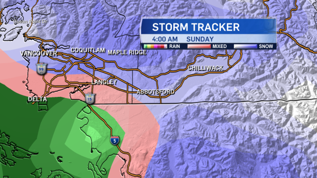
Residents of B.C.'s South Coast could see some snow over the weekend as a winter weather system heads south bringing snow to some parts of the province.
Environment Canada issued a special weather statement for part of Vancouver Island, the southern Gulf Islands, Metro Vancouver and the Fraser Valley on Friday afternoon.
The statement suggests a weather system will reach the South Coast Saturday night, bringing a chance of flurries with it. The weather agency forecasts the precipitation will start as rain, but change to snow later in the evening, especially inland and over higher elevations.
The snow is expected to taper off on Sunday morning as the system blows further south.
Most will not see significant snowfall, with only two centimetres expected to fall in Metro Vancouver, Greater Victoria and the Gulf Islands. Those in the Fraser Valley and the Malahat may see as much as five centimetres, and residents of East Vancouver Island could see as much as 10. Those in the Nanaimo and Duncan areas could see 15 centimetres of snow by the time the storm passes.
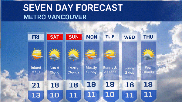
The forecasted high on Saturday in Vancouver is 5 C, with a low of 1 C at night. Environment Canada expects the temperature to warm up again Sunday to 7 C, with a 60 per cent chance of showers. The seasonal norm for this time of year is a high of 9, low of 2. The greatest snowfall on record for Feb. 25 was in 1955, when 3.6 centimetres fell over the Metro area.
We're not done with winter weather yet!
— Ann Luu (@ann_luu) February 25, 2017
Your 5 Day Forecast: pic.twitter.com/lUPEFSDe4d
While the weekend flurries are unlikely to have a major impact on the South Coast, another storm system coming from the north is expected to hit the area on Tuesday, bringing the potential for more snow. But any accumulation will be washed away when a series of Pacific weather systems arrive starting Wednesday, bringing warm air and rain to the region.